Arkansas Post is an unincorporated community located along the north side of the Arkansas River in Arkansas County, Arkansas, United States, near the Arkansas Post National Memorial. Arkansas Highway 169 ends here.

The Arkansas Post was the first European settlement in the Mississippi Alluvial Plain and present-day Arkansas. Henri de Tonti established it in 1686 as a French trading post on the lower Arkansas River, where the French and Spanish traded with the Quapaw people for years.

Pacaha was a Native American polity encountered in 1541 by the Hernando de Soto expedition. This group inhabited fortified villages in what is today the northeastern portion of the U.S. state of Arkansas.
Casqui was a Native American polity visited in 1541 by the Hernando de Soto expedition. This group inhabited fortified villages in eastern Arkansas.

The Mississippian culture was a Native American civilization that flourished in what is now the Midwestern, Eastern, and Southeastern United States from approximately 800 CE to 1600 CE, varying regionally. It was known for building large, earthen platform mounds, and often other shaped mounds as well. It was composed of a series of urban settlements and satellite villages linked together by loose trading networks. The largest city was Cahokia, believed to be a major religious center located in what is present-day southern Illinois.

The Quapaw people are a tribe of Native Americans that coalesced in what is known as the Midwest and Ohio Valley of the present-day United States. The Dhegiha Siouan-speaking tribe historically migrated from the Ohio Valley area to the west side of the Mississippi River and resettled in what is now the state of Arkansas; their name for themselves refers to this migration and to traveling downriver.

The Nodena Site is an archeological site east of Wilson, Arkansas and northeast of Reverie, Tennessee in Mississippi County, Arkansas, United States. Around 1400–1650 CE an aboriginal palisaded village existed in the Nodena area on a meander bend of the Mississippi River. The Nodena site was discovered and first documented by Dr. James K. Hampson, archaeologist and owner of the plantation on which the Nodena site is located. Artifacts from this site are on display in the Hampson Museum State Park in Wilson, Arkansas. The Nodena Site is the type site for the Nodena Phase, believed by many archaeologists to be the province of Pacaha visited by Spanish explorer Hernando de Soto in 1542.

The Eaker Site (3MS105) is an archaeological site on Eaker Air Force Base near Blytheville, Arkansas that was declared a National Historic Landmark in 1996. The site is the largest and most intact Late Mississippian Nodena Phase village site within the Central Mississippi Valley, with archaeological evidence indicating a palisaded village some 50 acres (20 ha) in size, with hundreds of structures. The site's major period of occupation was 1350–1450 CE, although evidence of occupation dates back to 600 CE. The site is also hypothesized to have been occupied by the Quapaw prior to a migration further south, after which they made contact with Europeans in the late 17th century.
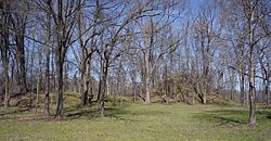
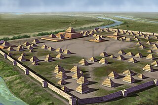
Parkin Archeological State Park, also known as Parkin Indian Mound, is an archeological site and state park in Parkin, Cross County, Arkansas. Around 1350–1650 CE an aboriginal palisaded village existed at the site, at the confluence of the St. Francis and Tyronza rivers. Artifacts from this site are on display at the site museum. The Parkin Site is the type site for the Parkin phase, an expression of the Mississippian culture from the Late Mississippian period. Many archeologists believe it to be part of the province of Casqui, documented as visited by Spanish explorer Hernando de Soto in 1542. Archeological artifacts from the village of the Parkin people are dated to 1400–1650 CE.
Nady is an unincorporated community in Arkansas County, Arkansas, United States. It is the location of a National Historic Landmark, the Menard-Hodges Site. The environs of Nady, at the southern tip of the Little Prairie, are in the portion of Arkansas that saw the earliest European settlement in what is now the state of Arkansas, including Tonty’s 1686 post. The Menard-Hodges archeological site, about one-half mile southwest of Wallace-Menard-Coose Cemetery, along with the adjacent Wallace Bottom archeological site, appear to be the locations of the late 1600s Quapaw village of Osotouy, Tonty’s 1686 Post, and the early to mid-1700s French Arkansas Post.
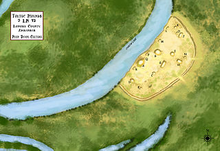
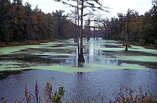
Toltec Mounds Archeological State Park, also known as Knapp Mounds, Toltec Mounds Site or Toltec Mounds, is an archaeological site from the Late Woodland period in Arkansas that protects an 18-mound complex with the tallest surviving prehistoric mounds in Arkansas. The site is on the banks of Mound Lake, an oxbow lake of the Arkansas River. It was occupied by its original inhabitants from 600 to 1050 CE. The site is designated as a National Historic Landmark.

The Plaquemine culture was an archaeological culture centered on the Lower Mississippi River valley. It had a deep history in the area stretching back through the earlier Coles Creek and Troyville cultures to the Marksville culture. The Natchez and related Taensa peoples were their historic period descendants. The type site for the culture is the Medora Site in Louisiana; while other examples include the Anna, Emerald, Holly Bluff, and Winterville sites in Mississippi.
Phyllis Morse (Anderson) is an American archaeologist.

The C.H. Nash Museum at Chucalissa is located on and exhibits excavated materials of the Mississippian culture archaeological site known as Chucalissa which means "abandoned house" in Choctaw. The site is located adjacent to the T. O. Fuller State Park within the city of Memphis, Tennessee, United States. Chucalissa was designated National Historic Landmark in 1994 due to its importance as one of the best-preserved and major prehistoric settlement sites in the region.
The Jere Shine Site (1MT6) is an archaeological site on the Tallapoosa River near its confluence with the Coosa River in modern Montgomery County, Alabama. Based on comparison of archaeological remains and pottery styles, scholars believe that it was most likely occupied from 1400–1550 CE by people of the South Appalachian Mississippian culture.

The Nodena Phase is an archaeological phase in eastern Arkansas and southeastern Missouri of the Late Mississippian culture which dates from about 1400–1650 CE. The Nodena Phase is known from a collection of villages along the Mississippi River between the Missouri Bootheel and Wapanocca Lake. They practiced extensive maize agriculture and artificial cranial deformation and were members of a continent wide trade and religious network known as the Southeastern Ceremonial Complex, which brought chert, whelk shells, and other exotic goods to the area.
The Carson Mounds,, also known as the Carson Site and Carson-Montgomery- is a large Mississippian culture archaeological site located near Clarksdale in Coahoma County, Mississippi in the Yazoo Basin. Only a few large earthen mounds are still present at Carson to this day. Archaeologists have suggested that Carson is one of the more important archaeological sites in the state of Mississippi.
Quigualtam or Quilgualtanqui was a powerful Native American Plaquemine culture polity encountered in 1542–1543 by the Hernando de Soto expedition. The capital of the polity and its chieftain also bore the same name; although neither the chief nor his settlements were ever visited in person by the expedition. Their encounters consisted of messages sent by runners and a three-day long canoe battle on the Mississippi River. Multiple archaeological cultures, archaeological sites, and protohistoric and early historic period Native American groups have been proposed by historians and archaeologists to identify the polity, but their identity will probably never be known with any degree of certainty.