List of National Historic Landmarks in Arkansas

Last updated

The National Historic Landmarks in Arkansas represent Arkansas's history from the Louisiana Purchase through the Civil War and the Civil Rights Movement. It contains the landmarks designated by the U.S. Federal Government for the U.S. state of Arkansas. There are 17 National Historic Landmarks (NHLs) in Arkansas. Another NHL was formerly listed in the state but was moved to Oakland, California.

Contents

This page includes a list of National Park Service-administered historic areas in Arkansas.

National Historic Landmarks

This is a complete list of the 17 National Historic Landmarks in Arkansas.

[1] Landmark nameImageDate designated [2] Location CountyDescription
1 Arkansas Post
Arkansas Post ARKANSAS POST NATIONAL MEMORIAL.jpg
Arkansas Post
October 9, 1960
(#66000198)
Gillett
34°01′09″N91°20′54″W / 34.01907°N 91.34835°W / 34.01907; -91.34835 (Arkansas Post)
Arkansas Commemorates the first semi-permanent European settlement in the Lower Mississippi Valley (1686); an American Revolutionary War skirmish (1783); the first territorial capital of Arkansas (1819–1821); and the American Civil War Battle of Fort Hindman (1863)
2 Daisy Bates House
Daisy Bates House Daisy Bates House.JPG
Daisy Bates House
January 3, 2001
(#01000072)
Little Rock
34°43′18″N92°17′00″W / 34.721667°N 92.283333°W / 34.721667; -92.283333 (Daisy Bates House)
Pulaski Supporting site for desegregation of Little Rock Central High School
3 Bathhouse Row
Bathhouse Row Hot Springs Hale Bathhouse 2006.jpg
Bathhouse Row
May 28, 1987
(#74000275)
Hot Springs
34°30′44″N93°03′13″W / 34.51212°N 93.05361°W / 34.51212; -93.05361 (Bathhouse Row)
Garland In Hot Springs National Park; largest collection of bathhouses in the United States; remains of the only federally-run spa
4 Beginning Point of the Louisiana Purchase Land Survey
Beginning Point of the Louisiana Purchase Land Survey Louisiana Purchase State Park 007.jpg
Beginning Point of the Louisiana Purchase Land Survey
April 19, 1993
(#72000206)
Blackton
34°38′42″N91°03′05″W / 34.64489°N 91.05139°W / 34.64489; -91.05139 (Beginning Point of the Louisiana Purchase Land Survey)
Lee, Phillips, and Monroe Point from which the lands acquired through the Louisiana Purchase of 1803 were subsequently surveyed [3]
5 Camden Expedition Sites
Camden Expedition Sites Fort Southerland 003.jpg
Camden Expedition Sites
April 19, 1994
(#94001182)
Camden and widely scattered sites across seven counties
33°35′04″N92°50′04″W / 33.584556°N 92.834333°W / 33.584556; -92.834333 (Camden Expedition Sites)
Clark, Cleveland, Grant, Hempstead, Nevada, Ouachita, and Pulaski Old U.S. Arsenal, Elkin's Ferry, Prairie De Ane Battlefield, Confederate State Capitol, Poison Springs Battlefield, Fort Lookout, Marks' Mills Battlefield, and Jenkins' Ferry Battlefield
6 Centennial Baptist Church
Centennial Baptist Church Centennial Baptist Church, Helena-West Helena, AR.jpg
Centennial Baptist Church
July 31, 2003
(#87000518)
Helena-West Helena
34°31′32″N90°35′27″W / 34.525469°N 90.590731°W / 34.525469; -90.590731 (Centennial Baptist Church)
Phillips Where Elias Camp Morris preached, unofficial headquarters for National Baptist Convention
7 City of Oakland (USS Hoga) (Tug)
City of Oakland (USS Hoga) (Tug) Hoga-26-03-2006.jpg
City of Oakland (USS Hoga) (Tug)
June 30, 1989
(#89001429)
North Little Rock
34°45′09″N92°16′04″W / 34.752420°N 92.267818°W / 34.752420; -92.267818 (City of Oakland (USS Hoga) (Tug))
Pulaski Tugboat; at Pearl Harbor fought ship fires and helped push sinking USS Nevada out of the ship channel; served Oakland harbor for many years; The vessel was transferred to the Arkansas Inland Maritime Museum (AIMM) in 2005 [4] and was scheduled to be moved to North Little Rock, Arkansas in 2007. The move has been delayed by damage from Hurricane Katrina along the proposed tow route to AIMM and transport costs. [5] She was moved to the Arkansas Inland Maritime Museum in November 2015.
8 Eaker Site
Eaker Site Eaker Site overview.jpg
Eaker Site
June 19, 1996
(#91001048)
Blytheville
35°57′48″N89°56′04″W / 35.963333°N 89.934444°W / 35.963333; -89.934444 (Eaker Site)
Mississippi Archaeological site; shows evidence of pre-historic Nodena populations and also Quapaw occupation
9 Fort Smith
Fort Smith Fort Smith, Commissary Building, 100 South Garrison Avenue, Fort Smith (Sebastian County, Arkansas).jpg
Fort Smith
December 19, 1960
(#66000202)
Fort Smith
35°20′36″N94°25′22″W / 35.3433°N 94.42278°W / 35.3433; -94.42278 (Fort Smith)
Sebastian This site includes the remains of two 19th-century U.S. military forts and the Federal Court for the Western District of Arkansas.
10 Little Rock Central High School
Little Rock Central High School Central High in Little Rock 11.jpg
Little Rock Central High School
May 20, 1982
(#01000274)
Little Rock
34°44′16″N92°17′52″W / 34.73775°N 92.29775°W / 34.73775; -92.29775 (Little Rock Central High School)
Pulaski Focal point of the Little Rock Integration Crisis of 1957
11 Menard–Hodges site
Menard-Hodges site Menard-Hodges2.jpg
Menard–Hodges site
April 11, 1989
(#85003542)
Nady
34°00′14″N91°15′15″W / 34.003869°N 91.254214°W / 34.003869; -91.254214 (Menard–Hodges site)
Arkansas 
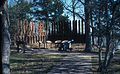
Site includes two large mounds and several house mounds, as well as remains of a 17th-century French trading post; now owned by the National Park Service and administered as part of the Arkansas Post National Memorial.
12 Nodena site
Nodena site Nodena Site fields.jpg
Nodena site
February 19, 1964
(#66000201)
Wilson
35°33′15″N89°57′06″W / 35.554286°N 89.951703°W / 35.554286; -89.951703 (Nodena site)
Mississippi 
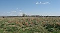
Located on Nodena Plantation; type site for an important Late Mississippian cultural component, the Nodena phase; date from about 1400-1700 AD; first excavations in 1897.
13 Old State House
Old State House OldStateHouseLittleRock2008.jpg
Old State House
December 9, 1997
(#69000037)
Little Rock
34°44′55″N92°16′24″W / 34.74856°N 92.27333°W / 34.74856; -92.27333 (Old State House)
Pulaski Oldest surviving state capitol building west of the Mississippi River.
14 Parkin Indian Mound
Parkin Indian Mound Parkin Site mound and moat HRoe 2006.jpg
Parkin Indian Mound
July 19, 1964
(#66000200)
Parkin
35°16′38″N90°33′16″W / 35.2771°N 90.55458°W / 35.2771; -90.55458 (Parkin Indian Mound)
Cross A Late Mississippian and protohistoric palisaded village with one mound; may be the town of Casqui mentioned by 16th century Spanish explorer Hernando de Soto.
15 Joseph Taylor Robinson House
Joseph Taylor Robinson House Joseph Taylor Robinson House.JPG
Joseph Taylor Robinson House
October 12, 1992
(#75000411)
Little Rock
34°43′40″N92°16′44″W / 34.727639°N 92.278806°W / 34.727639; -92.278806 (Joseph Taylor Robinson House)
Pulaski Home of influential Arkansas governor and U.S. senator
16 Rohwer Relocation Center Memorial Cemetery
Rohwer Relocation Center Memorial Cemetery Monument to the Men of the 100th Battalion, 442nd Regimental Combat Team, Rohwer Memorial Cemetery.jpg
Rohwer Relocation Center Memorial Cemetery
July 6, 1992
(#92001882)
Rohwer
33°45′52″N91°16′49″W / 33.76456°N 91.28016°W / 33.76456; -91.28016 (Rohwer Relocation Center Memorial Cemetery)
Desha Site of a World War II Japanese American internment camp
17 Toltec Mounds Site
Toltec Mounds Site Chromesun toltec mounds photo01.jpg
Toltec Mounds Site
June 2, 1978
(#73000382)
Scott
34°38′49″N92°03′55″W / 34.6469°N 92.065278°W / 34.6469; -92.065278 (Toltec Mounds Site)
Lonoke One of the most significant remnants of Native American life in the state.

Historic areas administered by the National Park Service

National Historic Sites, National Historical Parks, National Monuments, and certain other areas listed in the National Park system are historic landmarks of national importance that are highly protected already, often before the inauguration of the NHL program in 1960, and are then often not also named NHLs per se. There are four of these in Arkansas. The National Park Service lists these four together with the NHLs in the state, [6] The Arkansas Post National Memorial, the Fort Smith National Historic Site (shared with Oklahoma) and the Little Rock Central High School National Historic Site are also NHLs and are listed above. The remaining one is:

Landmark name
ImageDate established [7] LocationCountyDescription
1 Pea Ridge National Military Park 20 July 1956 Pea Ridge Benton Site of Battle of Pea Ridge, March 7 and 8, 1862, a Union victory in the American Civil War

Other National Park Service-administered areas in Arkansas are the Buffalo National River and the Hot Springs National Park (not historic per se but which includes Bathhouse Row, an NHL listed above).

See also

Related Research Articles

<span class="mw-page-title-main">Arkansas Post</span> Historic site and museum in Arkansas County, Arkansas

The Arkansas Post, formally the Arkansas Post National Memorial, was the first European settlement in the Mississippi Alluvial Plain and present-day U.S. state of Arkansas. In 1686, Henri de Tonti established it on behalf of Louis XIV of France for the purpose of trading with the Quapaw Nation. The French, Spanish, and Americans, who acquired the territory in 1803 with the Louisiana Purchase, considered the site of strategic value. It was the capital of Arkansas from 1819 until 1821 when the territorial government relocated to Little Rock.

<span class="mw-page-title-main">Camden Expedition Sites National Historic Landmark</span> Historic district in Arkansas, United States

The Camden Expedition Sites is a national historic landmark consisting of nine nationally significant historic places in southwest Arkansas where events of the Union army's disastrous Camden Expedition of 1864 occurred during the American Civil War. The Union was attempting to take over Shreveport, Louisiana. Each of the sites are individually listed on the National Register of Historic Places. It was designated a national historic landmark on April 19, 1994.

<span class="mw-page-title-main">Louisiana Purchase Historic State Park</span> Park in Arkansas, US

The Louisiana Purchase Historic State Park, located in eastern Arkansas, commemorates the initial point from which the lands acquired through the Louisiana Purchase were subsequently surveyed. The park encompasses 37.5 acres (15.2 ha) of forested wetlands, a landform which is regionally in decline due to agricultural development practices that include draining such areas. On the survey point is a 6-foot (1.8 m) marker erected in 1926 by the L'Anguille Chapter of the Daughters of the American Revolution It was listed on the National Register of Historic Places and designated as a National Historic Landmark.

<span class="mw-page-title-main">Plum Bayou Mounds Archeological State Park</span> Archaeological site from the Late Woodland period in Arkansas

Plum Bayou Mounds Archeological State Park, formerly known as "Toltec Mounds Archeological State Park", also known as Knapp Mounds, Toltec Mounds or Toltec Mounds site, is an archaeological site from the Late Woodland period in Arkansas that protects an 18-mound complex with the tallest surviving prehistoric mounds in Arkansas. The site is on the banks of Mound Lake, an oxbow lake of the Arkansas River. It was occupied by its original inhabitants from the 7th to the 11th century. The site is designated as a National Historic Landmark.

References

  1. Numbers represent an alphabetical ordering by significant words. Various colorings, defined here, differentiate National Historic Landmarks and historic districts from other NRHP buildings, structures, sites or objects.
  2. The eight-digit number below each date is the number assigned to each location in the National Register Information System database, which can be viewed by clicking the number.
  3. "Beginning Point of the Louisiana Purchase Survey". National Park Service. Archived from the original on March 1, 2007. Retrieved September 20, 2007.
  4. "National Historic Landmarks Program: City of Oakland (USS Hoga) (Tug)". National Park Service. Archived from the original on June 6, 2011. Retrieved April 29, 2009.
  5. "America's 11 Most Endangered Historic Places". National Trust for Historic Preservation . Retrieved July 2, 2009.
  6. These are listed on p.111 of "National Historic Landmarks Survey: List of National Historic Landmarks by State"
  7. Date of listing as National Monument or similar designation, from various sources in articles indexed.
Map all coordinates using: OpenStreetMap