Sharp County, Arkansas

Last updated

Sharp County
Sherman Bates House.JPG
Map of Arkansas highlighting Sharp County.svg
Location within the U.S. state of Arkansas
Arkansas in United States.svg
Arkansas's location within the U.S.
Coordinates: 36°09′21″N91°30′18″W / 36.155833333333°N 91.505°W / 36.155833333333; -91.505
CountryFlag of the United States.svg United States
StateFlag of Arkansas.svg  Arkansas
FoundedJuly 18, 1868
Named for Ephraim Sharp
Seat Ash Flat
Largest city Cherokee Village
Area
  Total
606 sq mi (1,570 km2)
  Land604 sq mi (1,560 km2)
  Water2.0 sq mi (5 km2)  0.3%
Population
 (2020)
  Total
17,271
  Density29/sq mi (11/km2)
Time zone UTC−6 (Central)
  Summer (DST) UTC−5 (CDT)
Congressional district 1st
Website sharpcounty.arkansas.gov

Sharp County is a county located in the U.S. state of Arkansas. As of the 2020 census, the population was 17,271. [1] The county seat is Ash Flat. [2] The county was formed on July 18, 1868, and named for Ephraim Sharp, a state legislator from the area.

Contents

Geography

According to the U.S. Census Bureau, the county has a total area of 606 square miles (1,570 km2), of which 604 square miles (1,560 km2) is land and 2.0 square miles (5.2 km2) (0.3%) is water. [3]

Major highways

Adjacent counties

Demographics

Historical population
CensusPop.Note
1870 5,400
1880 9,04767.5%
1890 10,41815.2%
1900 12,19917.1%
1910 11,688−4.2%
1920 11,132−4.8%
1930 10,715−3.7%
1940 11,4977.3%
1950 8,999−21.7%
1960 6,319−29.8%
1970 8,23330.3%
1980 14,60777.4%
1990 14,109−3.4%
2000 17,11921.3%
2010 17,2640.8%
2020 17,2710.0%
2023 (est.)17,968 [4] 4.0%
U.S. Decennial Census [5]
1790–1960 [6] 1900–1990 [7]
1990–2000 [8] 2010 [9]
Age pyramid Sharp County USA Sharp County, Arkansas age pyramid.svg
Age pyramid Sharp County

2020 census

Sharp County racial composition [11]
RaceNumberPercentage
White (non-Hispanic)15,72991.07%
Black or African American (non-Hispanic)1140.66%
Native American 1210.7%
Asian 570.33%
Pacific Islander 200.12%
Other/Mixed 8685.03%
Hispanic or Latino 3622.1%

As of the 2020 United States census, there were 17,271 people, 7,447 households, and 4,420 families residing in the county.

2000 census

As of the 2000 census, [12] there were 17,119 people, 7,211 households, and 5,141 families residing in the county. The population density was 28 people per square mile (11 people/km2). There were 9,342 housing units at an average density of 16 units per square mile (6.2 units/km2). The racial makeup of the county was 97.14% White, 0.49% Black or African American, 0.68% Native American, 0.12% Asian, 0.02% Pacific Islander, 0.16% from other races, and 1.39% from two or more races. 0.98% of the population were Hispanic or Latino of any race.

There were 7,211 households, out of which 25.80% had children under the age of 18 living with them, 59.90% were married couples living together, 8.10% had a female householder with no husband present, and 28.70% were non-families. 25.60% of all households were made up of individuals, and 14.40% had someone living alone who was 65 years of age or older. The average household size was 2.34 and the average family size was 2.79.

In the county, the population was spread out, with 21.90% under the age of 18, 6.30% from 18 to 24, 22.80% from 25 to 44, 25.50% from 45 to 64, and 23.60% who were 65 years of age or older. The median age was 44 years. For every 100 females there were 92.40 males. For every 100 females age 18 and over, there were 90.20 males.

The median income for a household in the county was $25,152, and the median income for a family was $29,691. Males had a median income of $23,329 versus $16,884 for females. The per capita income for the county was $14,143. About 13.20% of families and 18.20% of the population were below the poverty line, including 25.40% of those under age 18 and 13.20% of those age 65 or over.

Government

In recent years, Sharp County has trended heavily towards the Republican Party. The last Democrat to carry the county was Arkansas-native Bill Clinton in 1996. Since then, Democratic vote shares have plummeted, with Joe Biden in 2020 losing the county by a 4-to-1 margin to Republican Donald Trump, despite winning the national election.

United States presidential election results for Sharp County, Arkansas [13]
Year Republican Democratic Third party(ies)
No.%No.%No.%
2024 5,97880.38%1,31617.70%1431.92%
2020 5,93878.48%1,39818.48%2303.04%
2016 5,40774.59%1,47220.31%3705.10%
2012 4,92167.57%2,09228.72%2703.71%
2008 4,53562.53%2,43633.59%2813.87%
2004 4,09754.85%3,26543.71%1081.45%
2000 3,69851.89%3,23645.41%1922.69%
1996 2,63537.80%3,57351.26%76210.93%
1992 2,48634.55%3,76152.27%94913.19%
1988 3,62354.79%2,95544.69%340.51%
1984 4,39263.38%2,49235.96%460.66%
1980 3,42053.30%2,77443.24%2223.46%
1976 2,15137.85%3,53262.15%00.00%
1972 2,67769.71%1,15430.05%90.23%
1968 1,13632.83%1,02529.62%1,29937.54%
1964 1,21539.88%1,81059.40%220.72%
1960 91151.01%80745.18%683.81%
1956 64540.31%92757.94%281.75%
1952 65538.60%1,03961.23%30.18%
1948 29520.30%1,07874.19%805.51%
1944 66435.08%1,21764.29%120.63%
1940 43328.17%1,09971.50%50.33%
1936 28923.40%93475.63%120.97%
1932 1429.57%1,33489.89%80.54%
1928 50138.24%80861.68%10.08%
1924 21021.11%72973.27%565.63%
1920 40026.42%99565.72%1197.86%
1916 25120.52%97279.48%00.00%
1912 11410.75%68164.25%26525.00%
1908 31723.05%97070.55%886.40%
1904 28828.29%67165.91%595.80%
1900 39426.84%1,05972.14%151.02%
1896 23014.23%1,38385.58%30.19%

Communities

Cities

Towns

Unincorporated communities

Townships

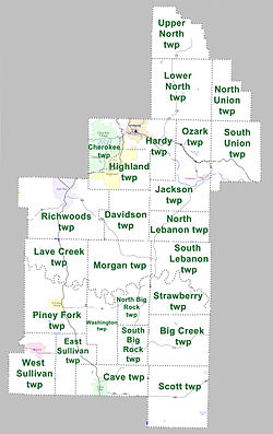
Townships in Sharp County, Arkansas as of 2010 Sharp County Arkansas 2010 Township Map large.jpg
Townships in Sharp County, Arkansas as of 2010

Townships in Arkansas are the divisions of a county. Each township includes unincorporated areas; some may have incorporated cities or towns within part of their boundaries. Arkansas townships have limited purposes in modern times. However, the United States census does list Arkansas population based on townships (sometimes referred to as "county subdivisions" or "minor civil divisions"). Townships are also of value for historical purposes in terms of genealogical research. Each town or city is within one or more townships in an Arkansas county based on census maps and publications. The townships of Sharp County are listed below; listed in parentheses are the cities, towns, and/or census-designated places that are fully or partially inside the township. [14] [15]

Sharp County was featured on the PBS program Independent Lens for its 1906 "banishment" of all of its Black residents." [16]

See also

Related Research Articles

<span class="mw-page-title-main">Delaware County, Oklahoma</span> County in Oklahoma, United States

Delaware County is a county located in the U.S. state of Oklahoma. As of the 2020 census, the population was 40,397. Its county seat is Jay. The county was named for the Delaware Indians, who had established a village in the area prior to the Cherokees being assigned to relocate to Indian Territory in the 1830s. Delaware County was created in 1907. Prior to becoming Delaware County, a large portion of the area was known as the Delaware District of the Cherokee Nation. Today, Delaware County continues to be recognized by the Cherokee Nation as the Delaware District.

<span class="mw-page-title-main">Adair County, Oklahoma</span> County in Oklahoma, United States

Adair County is a county located in the U.S. state of Oklahoma. As of the 2020 census, the population was 19,495. Its county seat is Stilwell. Adair County was named after the Adair family of the Cherokee tribe. One source says that the county was specifically named for Watt Adair, one of the first Cherokees to settle in the area. Adair County is part of the Cherokee Nation reservation.

<span class="mw-page-title-main">Yell County, Arkansas</span> County in Arkansas, United States

Yell County is a county in the U.S. state of Arkansas. As of the 2020 census, the population was 20,263. The county has two county seats, Dardanelle and Danville. Yell County is Arkansas's 42nd county, formed on December 5, 1840, from portions of Scott and Pope counties. It was named after Archibald Yell, who was the state's first member of the United States House of Representatives and the second governor of Arkansas. He died in combat at the Battle of Buena Vista during the Mexican–American War.

<span class="mw-page-title-main">Marion County, Arkansas</span> County in Arkansas, United States

Marion County is located in the Ozark Mountains in the U.S. state of Arkansas. The county is named for Francis Marion, the famous "Swamp Fox" of the Revolutionary War. Created as Arkansas's 35th county in 1836, Marion County is home to one incorporated town and four incorporated cities, including Yellville, the county seat. The county is also the site of numerous unincorporated communities and ghost towns. The county included part of what is now Searcy County, Arkansas, with many opposing to dividing them, which helped fueled the bloody Tutt-Everett War between 1844 and 1850.

<span class="mw-page-title-main">Lawrence County, Arkansas</span> County in Arkansas, United States

Lawrence County is a county located in the U.S. state of Arkansas. As of the 2020 census, the population was 16,216. The county seat is Walnut Ridge. Lawrence County is Arkansas's second county, formed on January 15, 1815, and named for Captain James Lawrence who fought in the War of 1812. It is an alcohol prohibition or dry county.

<span class="mw-page-title-main">Johnson County, Arkansas</span> County in Arkansas, United States

Johnson County is a county located in the U.S. state of Arkansas. As of the 2020 census, the population was 25,749. The county seat is Clarksville. Johnson County is Arkansas's 30th county, formed on November 16, 1833, from a portion of Pope County and named for Benjamin Johnson, a Territorial Judge. It is an alcohol prohibition or dry county.

<span class="mw-page-title-main">Izard County, Arkansas</span> County in Arkansas, United States

Izard County is a county located in the U.S. state of Arkansas. As of the 2020 census, the population was 13,577. The county seat is Melbourne. Izard County is Arkansas's 13th county, formed on October 27, 1825, and named for War of 1812 General and Arkansas Territorial Governor George Izard. It is an alcohol prohibition or dry county.

<span class="mw-page-title-main">Independence County, Arkansas</span> County in Arkansas, United States

Independence County is a county located in the U.S. state of Arkansas. As of the 2020 census, the population was 37,938. The county seat is Batesville. Independence County is Arkansas's ninth county, formed on October 20, 1820, from a portion of Lawrence County and named in commemoration of the Declaration of Independence. It is an alcohol prohibition or dry county.

<span class="mw-page-title-main">Fulton County, Arkansas</span> County in Arkansas, United States

Fulton County is a county located in the U.S. state of Arkansas. As of the 2020 census, the population was 12,075. The county seat is Salem. Fulton County was formed on December 21, 1842, and named for William Fulton, the last governor of the Arkansas Territory. It is an alcohol prohibition or dry county.

<span class="mw-page-title-main">Franklin County, Arkansas</span> County in Arkansas, United States

Franklin County is a county in Arkansas. As of the 2020 census, the population was 17,097. The county has two county seats, Charleston and Ozark. The county was formed on December 19, 1837, and named for Benjamin Franklin, American statesman. Franklin County is a damp county, with alcohol sales allowed except in Prairie & Alix townships, and limits on liquor sales in the city of Branch.

<span class="mw-page-title-main">Crawford County, Arkansas</span> County in Arkansas, United States

Crawford County is a county located in the Ozarks region of the U.S. state of Arkansas. As of the 2020 census, the population was 60,133. The county seat and largest city is Van Buren. Crawford County was formed on October 18, 1820, from the former Lovely County and Indian Territory, and was named for William H. Crawford, the United States Secretary of War in 1815.

<span class="mw-page-title-main">Conway County, Arkansas</span> County in Arkansas, United States

Conway County is a county located in the U.S. state of Arkansas. Created as Arkansas's 11th county on October 20, 1825, Conway County has four incorporated municipalities, including Morrilton, the county seat and most populous city. The county is also the site of numerous unincorporated communities and ghost towns. The county is named for Henry Wharton Conway, a politician from a powerful political family who served as the delegate from the Arkansas Territory to the U.S. Congress from 1823 to 1827.

<span class="mw-page-title-main">Boone County, Arkansas</span> County in Arkansas, United States

Boone County is a county located in the U.S. state of Arkansas, along the Missouri border. As of the 2020 census, the population was 37,373. The county seat is Harrison. It is Arkansas's 62nd county, formed on April 9, 1869.

<span class="mw-page-title-main">Benton County, Arkansas</span> County in Arkansas, United States

Benton County is a county in the Northwest region of the U.S. state of Arkansas. Created as Arkansas' 35th county on September 30, 1836, Benton County contains thirteen incorporated municipalities, including Bentonville, the county seat, and Rogers, the most populous city. The county was named after Thomas Hart Benton, a U.S. Senator from Missouri influential in Arkansas statehood.

<span class="mw-page-title-main">Pineville, Arkansas</span> Town in Arkansas, United States

Pineville is a town in Izard County, Arkansas, United States. The population was 238 at the 2010 census.

<span class="mw-page-title-main">Ravenden Springs, Arkansas</span> Town in Arkansas, United States

Ravenden Springs is a town in Randolph County, Arkansas, United States. The population was 119 at the 2020 census.

<span class="mw-page-title-main">Hardy, Arkansas</span> City in Sharp and Fulton counties, US

Hardy is the 2nd oldest city in Sharp and Fulton counties in the U.S. state of Arkansas. The population was 765 in 2020.

<span class="mw-page-title-main">Highland, Arkansas</span> City in Arkansas, United States

Highland is a city in Sharp County, Arkansas, United States. The city was incorporated in 1998 and is located in Sharp County. It is the fourth largest city in Sharp County with a population of 1,015 in 2021

<span class="mw-page-title-main">Williford, Arkansas</span> Town in Arkansas, United States

Williford is a town in Sharp County, Arkansas, United States. The population was 70 in 2020

<span class="mw-page-title-main">Pioneer Township, Michigan</span> Civil township in Michigan, United States

Pioneer Township is a civil township of Missaukee County in the U.S. state of Michigan. The population was 508 at the 2020 census, up from 451 in 2010.

References

  1. "Census - Geography Profile: Sharp County, Arkansas". United States Census Bureau . Retrieved January 21, 2023.
  2. "Find a County". National Association of Counties. Retrieved June 7, 2011.
  3. "2010 Census Gazetteer Files". United States Census Bureau. August 22, 2012. Retrieved August 27, 2015.
  4. "Annual Estimates of the Resident Population for Counties: April 1, 2020 to July 1, 2023". United States Census Bureau. Retrieved March 30, 2024.
  5. "U.S. Decennial Census". United States Census Bureau. Retrieved August 27, 2015.
  6. "Historical Census Browser". University of Virginia Library. Retrieved August 27, 2015.
  7. Forstall, Richard L., ed. (March 27, 1995). "Population of Counties by Decennial Census: 1900 to 1990". United States Census Bureau. Retrieved August 27, 2015.
  8. "Census 2000 PHC-T-4. Ranking Tables for Counties: 1990 and 2000" (PDF). United States Census Bureau. April 2, 2001. Archived (PDF) from the original on March 27, 2010. Retrieved August 27, 2015.
  9. "State & County QuickFacts". United States Census Bureau. Retrieved May 19, 2014.
  10. Based on 2000 census data
  11. "Explore Census Data". data.census.gov. Retrieved December 30, 2021.
  12. "U.S. Census website". United States Census Bureau . Retrieved May 14, 2011.
  13. "Dave Leip's Atlas of U.S. Presidential Elections" . Retrieved November 18, 2016.
  14. 2011 Boundary and Annexation Survey (BAS): Sharp County, AR (PDF) (Map). U. S. Census Bureau. Archived from the original (PDF) on October 19, 2012. Retrieved August 4, 2011.
  15. "Arkansas: 2010 Census Block Maps - County Subdivision". United States Census Bureau . Retrieved May 29, 2014.
  16. "Independent Lens . BANISHED . Banishment Map | PBS". Archived from the original on January 14, 2008.

36°09′21″N91°30′18″W / 36.15583°N 91.50500°W / 36.15583; -91.50500