National Register of Historic Places listings in Sharp County, Arkansas

Last updated
Location of Sharp County in Arkansas Map of Arkansas highlighting Sharp County.svg
Location of Sharp County in Arkansas

This is a list of the National Register of Historic Places listings in Sharp County, Arkansas.

Contents

This is intended to be a complete list of the properties and districts on the National Register of Historic Places in Sharp County, Arkansas, United States. The locations of National Register properties and districts for which the latitude and longitude coordinates are included below, may be seen in a map. [1]

There are 28 properties and districts listed on the National Register in the county.

Contents: Counties in Arkansas
This National Park Service list is complete through NPS recent listings posted April 3, 2020. [2]
Map all coordinates using: OpenStreetMap  
Download coordinates as: KML  ·  GPX

Current listings

[3] Name on the Register [4] ImageDate listed [5] Location City or townDescription
1 Sherman and Merlene Bates House
Sherman and Merlene Bates House Sherman and Merlene Bates House.JPG
Sherman and Merlene Bates House
October 4, 2002
(#02001077)
Junction of Dawson and Echo
36°18′54″N91°28′30″W / 36.315°N 91.475°W / 36.315; -91.475 (Sherman and Merlene Bates House)
Hardy
2 Sherman Bates House
Sherman Bates House Sherman Bates House.JPG
Sherman Bates House
December 17, 1998
(#98001515)
Junction of U.S. Route 63 and Echo Ln.
36°18′55″N91°28′30″W / 36.315278°N 91.475°W / 36.315278; -91.475 (Sherman Bates House)
Hardy
3 Fred Carter House
Fred Carter House Fred Carter House.JPG
Fred Carter House
December 17, 1998
(#98001510)
School Ave., north of its junction with 4th St.
36°19′09″N91°29′02″W / 36.319167°N 91.483889°W / 36.319167; -91.483889 (Fred Carter House)
Hardy
4 Coger House
Coger House Coger House.jpg
Coger House
June 2, 1982
(#82002134)
Main St.
36°04′16″N91°37′11″W / 36.071111°N 91.619722°W / 36.071111; -91.619722 (Coger House)
Evening Shade
5 Crystal River Tourist Camp
Crystal River Tourist Camp Crystal River Tourist Camp, Main Building.jpg
Crystal River Tourist Camp
June 6, 1991
(#91000620)
Junction of U.S. Route 167 and Cave St.
35°56′36″N91°32′52″W / 35.943333°N 91.547778°W / 35.943333; -91.547778 (Crystal River Tourist Camp)
Cave City
6 Ernest Daugherty House
Ernest Daugherty House Ernest Daugherty House.JPG
Ernest Daugherty House
December 17, 1998
(#98001513)
3rd St., west of its junction with Kelly Ave.
36°18′29″N91°28′49″W / 36.308056°N 91.480278°W / 36.308056; -91.480278 (Ernest Daugherty House)
Hardy
7 Sam Davidson House
Sam Davidson House Sam Davidson House.jpg
Sam Davidson House
June 2, 1982
(#82002135)
Cammack St.
36°04′23″N91°37′11″W / 36.073056°N 91.619722°W / 36.073056; -91.619722 (Sam Davidson House)
Evening Shade
8 W.A. Edwards House
W.A. Edwards House W.A. Edwards House.jpg
W.A. Edwards House
June 2, 1982
(#82002136)
Main St.
36°04′16″N91°37′12″W / 36.071111°N 91.62°W / 36.071111; -91.62 (W.A. Edwards House)
Evening Shade
9 Fred Graham House
Fred Graham House Fred Graham House.JPG
Fred Graham House
February 12, 1999
(#99000157)
U.S. Route 62, west of its junction with Springwood Rd.
36°18′53″N91°28′27″W / 36.314722°N 91.474167°W / 36.314722; -91.474167 (Fred Graham House)
Hardy
10 Hardy Cemetery Historic Section
Hardy Cemetery Historic Section Hardy Cemetery Historic Section, 2 of 3.jpg
Hardy Cemetery Historic Section
March 2, 2006
(#06000089)
Bounded by Main St., Kelly St., Cope Ave., and the BNSF railroad line
36°19′02″N91°28′44″W / 36.317222°N 91.478889°W / 36.317222; -91.478889 (Hardy Cemetery Historic Section)
Hardy
11 Hardy Downtown Historic District
Hardy Downtown Historic District Main Street, Hardy, Arkansas, USA.jpg
Hardy Downtown Historic District
September 22, 1995
(#95001121)
Roughly bounded by Kelly, Front, Church, and 3rd Sts.
36°18′58″N91°28′56″W / 36.316111°N 91.482222°W / 36.316111; -91.482222 (Hardy Downtown Historic District)
Hardy
12 Floyd Jackson House December 17, 1998
(#98001516)
Jackson St.
36°18′57″N91°29′46″W / 36.315833°N 91.496111°W / 36.315833; -91.496111 (Floyd Jackson House)
Hardy
13 David L. King House
David L. King House David L. King House.JPG
David L. King House
October 4, 2002
(#02001076)
2nd and Kelly St.
36°18′58″N91°28′46″W / 36.316111°N 91.479444°W / 36.316111; -91.479444 (David L. King House)
Hardy
14 Little Springs Missionary Baptist Church June 7, 2016
(#16000321)
4040 AR 58
36°04′32″N91°28′33″W / 36.075559°N 91.475736°W / 36.075559; -91.475736 (Little Springs Missionary Baptist Church)
Poughkeepsie
15 Esther Locke House
Esther Locke House Esther Locke House.JPG
Esther Locke House
December 17, 1998
(#98001509)
Junction of Spring and 3rd Sts.
36°19′02″N91°28′56″W / 36.317222°N 91.482222°W / 36.317222; -91.482222 (Esther Locke House)
Hardy
16 Web Long House and Motel
Web Long House and Motel Web Long House and Motel.JPG
Web Long House and Motel
December 17, 1998
(#98001512)
U.S. Route 63, east of its junction with Springwood Rd.
36°18′53″N91°28′22″W / 36.314722°N 91.472778°W / 36.314722; -91.472778 (Web Long House and Motel)
Hardy
17 John McCaleb House
John McCaleb House John McCaleb House.jpg
John McCaleb House
June 2, 1982
(#82002137)
Main St.
36°04′14″N91°37′34″W / 36.070556°N 91.626111°W / 36.070556; -91.626111 (John McCaleb House)
Evening Shade
18 Poughkeepsie School Building
Poughkeepsie School Building Poughkeepsie School Building.jpg
Poughkeepsie School Building
September 10, 1992
(#92001198)
Highway 58 south of County Road 137
36°04′22″N91°28′00″W / 36.072778°N 91.466667°W / 36.072778; -91.466667 (Poughkeepsie School Building)
Poughkeepsie
19 Charles W. Shaver House
Charles W. Shaver House Charles W. Shaver House.jpg
Charles W. Shaver House
September 30, 1982
(#82002139)
Court St.
36°04′22″N91°37′15″W / 36.072778°N 91.620833°W / 36.072778; -91.620833 (Charles W. Shaver House)
Evening Shade
20 John W. Shaver House
John W. Shaver House John W. Shaver House.jpg
John W. Shaver House
June 2, 1982
(#82002140)
Main St.
36°04′19″N91°37′10″W / 36.071944°N 91.619444°W / 36.071944; -91.619444 (John W. Shaver House)
Evening Shade
21 William Shaver House
William Shaver House William Shaver House.JPG
William Shaver House
December 17, 1998
(#98001511)
School Ave., north of its junction with 4th St.
36°19′08″N91°29′00″W / 36.318889°N 91.483333°W / 36.318889; -91.483333 (William Shaver House)
Hardy
22 Silas Sherrill House
Silas Sherrill House Silas Sherrill House.JPG
Silas Sherrill House
December 17, 1998
(#98001514)
Junction of 4th and Spring Sts.
36°19′05″N91°28′56″W / 36.318056°N 91.482222°W / 36.318056; -91.482222 (Silas Sherrill House)
Hardy
23 Stokes House
Stokes House Stokes House.jpg
Stokes House
June 2, 1982
(#82002141)
Cammack St.
36°04′15″N91°37′07″W / 36.070833°N 91.618611°W / 36.070833; -91.618611 (Stokes House)
Evening Shade
24 Carrie Tucker House
Carrie Tucker House Carrie Tucker House.JPG
Carrie Tucker House
February 12, 1999
(#99000156)
U.S. Routes 62/63, east of their junction with Echo Ln.
36°18′54″N91°28′28″W / 36.315°N 91.474444°W / 36.315; -91.474444 (Carrie Tucker House)
Hardy
25 Thomas Walker House
Thomas Walker House Thomas Walker House.JPG
Thomas Walker House
January 20, 2005
(#04001490)
201 N. Spring St.
36°18′52″N91°28′57″W / 36.314444°N 91.4825°W / 36.314444; -91.4825 (Thomas Walker House)
Hardy
26 Lee Weaver House
Lee Weaver House Lee Weaver House.JPG
Lee Weaver House
December 17, 1998
(#98001508)
Junction of Main and Cope Sts.
36°18′59″N91°28′44″W / 36.316389°N 91.478889°W / 36.316389; -91.478889 (Lee Weaver House)
Hardy
27 Williford Methodist Church
Williford Methodist Church Wiliford Methodist Church.jpg
Williford Methodist Church
November 27, 1992
(#92001629)
Northwest of the junction of Ferguson and Hail Sts.
36°15′10″N91°21′34″W / 36.252778°N 91.359444°W / 36.252778; -91.359444 (Williford Methodist Church)
Williford
28 Woodland Courts
Woodland Courts Woodland Courts.JPG
Woodland Courts
November 27, 1992
(#92001634)
Northwest of the junction of Dawson and Old CC Rds.
36°18′56″N91°28′26″W / 36.315556°N 91.473889°W / 36.315556; -91.473889 (Woodland Courts)
Hardy

Former listings

[3] Name on the RegisterImageDate listedDate removedLocationCity or townSummary
1 Cochran Store June 2, 1982
(#82002133)
October 4, 1999Main St.
Evening Shade
2 Herrn House September 29, 1976
(#76000469)
October 4, 1999W Main St.
Evening Shade
3 Maxville School Building September 10, 1992
(#92001199)
September 3, 1999US 167 N of Cave City
Cave City
4 Metcalfe House June 2, 1982
(#82002138)
January 14, 2002Gin Drive
Evening Shade

See also

Related Research Articles

National Register of Historic Places listings in Arkansas County, Arkansas Wikimedia list article

This is a list of the National Register of Historic Places listings in Arkansas County, Arkansas.

National Register of Historic Places listings in Drew County, Arkansas Wikimedia list article

This is a list of the National Register of Historic Places listings in Drew County, Arkansas.

National Register of Historic Places listings in Desha County, Arkansas Wikimedia list article

This is a list of the National Register of Historic Places listings in Desha County, Arkansas.

National Register of Historic Places listings in Franklin County, Arkansas Wikimedia list article

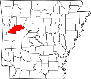
This is a list of the National Register of Historic Places listings in Franklin County, Arkansas.

National Register of Historic Places listings in Faulkner County, Arkansas Wikimedia list article

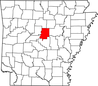
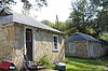
This is a list of the National Register of Historic Places listings in Faulkner County, Arkansas.

National Register of Historic Places listings in Garland County, Arkansas Wikimedia list article

This is a list of the National Register of Historic Places listings in Garland County, Arkansas.

National Register of Historic Places listings in Cleburne County, Arkansas Wikimedia list article

This is a list of the National Register of Historic Places listings in Cleburne County, Arkansas.

National Register of Historic Places listings in Dallas County, Arkansas Wikimedia list article

This is a list of the National Register of Historic Places listings in Dallas County, Arkansas.

National Register of Historic Places listings in Independence County, Arkansas Wikimedia list article

This is a list of the National Register of Historic Places listings in Independence County, Arkansas.

National Register of Historic Places listings in Jackson County, Arkansas Wikimedia list article

This is a list of the National Register of Historic Places listings in Jackson County, Arkansas.

National Register of Historic Places listings in Lee County, Arkansas Wikimedia list article

This is a list of the National Register of Historic Places listings in Lee County, Arkansas.

National Register of Historic Places listings in Logan County, Arkansas Wikimedia list article

This is a list of the National Register of Historic Places listings in Logan County, Arkansas.

National Register of Historic Places listings in Nevada County, Arkansas Wikimedia list article

This is a list of the National Register of Historic Places listings in Nevada County, Arkansas.

National Register of Historic Places listings in Ouachita County, Arkansas Wikimedia list article

This is a list of the National Register of Historic Places listings in Ouachita County, Arkansas.

National Register of Historic Places listings in Saline County, Arkansas Wikimedia list article

This is a list of the National Register of Historic Places listings in Saline County, Arkansas.

National Register of Historic Places listings in Pope County, Arkansas Wikimedia list article

This is a list of the National Register of Historic Places listings in Pope County, Arkansas.

National Register of Historic Places listings in Searcy County, Arkansas Wikimedia list article

This is a list of the National Register of Historic Places listings in Searcy County, Arkansas.

National Register of Historic Places listings in Union County, Arkansas Wikimedia list article

This is a list of the National Register of Historic Places listings in Union County, Arkansas.

National Register of Historic Places listings in Stone County, Arkansas Wikimedia list article

This is a list of the National Register of Historic Places listings in Stone County, Arkansas.

National Register of Historic Places listings in White County, Arkansas Wikimedia list article

This is a list of the National Register of Historic Places listings in White County, Arkansas.

References

  1. The latitude and longitude information provided in this table was derived originally from the National Register Information System, which has been found to be fairly accurate for about 99% of listings. Some locations in this table may have been corrected to current GPS standards.
  2. "National Register of Historic Places: Weekly List Actions". National Park Service, United States Department of the Interior. Retrieved on April 3, 2020.
  3. 1 2 Numbers represent an ordering by significant words. Various colorings, defined here, differentiate National Historic Landmarks and historic districts from other NRHP buildings, structures, sites or objects.
  4. "National Register Information System". National Register of Historic Places . National Park Service. March 13, 2009.
  5. The eight-digit number below each date is the number assigned to each location in the National Register Information System database, which can be viewed by clicking the number.