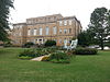
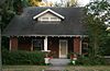
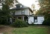
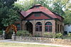
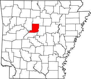
[3] Name on the Register [4] Image Date listed [5] Location City or town Description 1 Administration Building, University of Central Arkansas Administration Building, University of Central Arkansas January 24, 2011 (# 10001153 201 Donaghey Ave. 35°04′45″N 92°27′26″W / 35.079167°N 92.457222°W / 35.079167; -92.457222 (Administration Building, University of Central Arkansas ) Conway 2 Blessing Farmstead Blessing Farmstead September 5, 1990 (# 90001369 North of Enola 35°15′08″N 92°14′30″W / 35.252222°N 92.241667°W / 35.252222; -92.241667 (Blessing Farmstead ) Barney 3 Brown House Brown House December 22, 1982 (# 82000811 1604 Caldwell St. 35°05′24″N 92°26′44″W / 35.09°N 92.445556°W / 35.09; -92.445556 (Brown House ) Conway 4 Cadron Settlement Cadron Settlement May 17, 1974 (# 74000475 Highway 319W at Cadron Settlement Ln. 35°06′26″N 92°32′44″W / 35.107222°N 92.545556°W / 35.107222; -92.545556 (Cadron Settlement ) Conway A Trail of Tears site, [6] with early French and American settlements. 5 Castleberry-Harrington Historic District Castleberry-Harrington Historic District June 5, 2007 (# 07000503 Castleberry Rd. 35°15′36″N 92°25′36″W / 35.26°N 92.426667°W / 35.26; -92.426667 (Castleberry-Harrington Historic District ) Republican 6 Centerville United Methodist Church Upload image May 17, 2024 (# 100010313 271 McNew Cemetery Road 35°16′25″N 92°15′22″W / 35.2737°N 92.2561°W / 35.2737; -92.2561 (Centerville United Methodist Church ) Greenbrier 7 Century Flyer Century Flyer May 28, 2010 (# 10000284 150 E. Siebenmorgan Rd. 35°05′56″N 92°25′45″W / 35.098889°N 92.429167°W / 35.098889; -92.429167 (Century Flyer ) Conway Amusement park train on the grounds of the Conway Human Development Center 8 Church of Christ Church of Christ February 15, 2005 (# 05000040 Highway 310 35°19′33″N 92°20′07″W / 35.325833°N 92.335278°W / 35.325833; -92.335278 (Church of Christ ) Guy 9 Conway Commercial Historic District Conway Commercial Historic District September 23, 2010 (# 10000779 Roughly bounded by Main St. on the south, Harkrider St. and Spencer St. on the east, just south of Mill St. to the north, and Locust St. 35°05′34″N 92°26′24″W / 35.092778°N 92.44°W / 35.092778; -92.44 (Conway Commercial Historic District ) Conway 10 Conway Confederate Monument Conway Confederate Monument April 26, 1996 (# 96000455 Southwestern corner of the courthouse lawn, east of the junction of Robinson Ave. and Center St. 35°05′19″N 92°26′35″W / 35.088611°N 92.443056°W / 35.088611; -92.443056 (Conway Confederate Monument ) Conway 11 Earl and Oza Crownover-Brown House Earl and Oza Crownover-Brown House March 2, 2006 (# 06000088 133 S. Broadway 35°21′25″N 92°24′48″W / 35.356944°N 92.413333°W / 35.356944; -92.413333 (Earl and Oza Crownover-Brown House ) Damascus 12 O.L. Dunaway House O.L. Dunaway House July 19, 1996 (# 96000797 920 Center St. 35°05′26″N 92°26′42″W / 35.090556°N 92.445°W / 35.090556; -92.445 (O.L. Dunaway House ) Conway 13 Richard and Mettie Ealy House Richard and Mettie Ealy House September 30, 2005 (# 05001069 280 Solomon Grove Rd. 35°18′45″N 92°26′51″W / 35.3125°N 92.4475°W / 35.3125; -92.4475 (Richard and Mettie Ealy House ) Twin Groves 14 Farmers State Bank Farmers State Bank December 22, 1982 (# 82000812 1001 Front St. 35°05′31″N 92°26′28″W / 35.091944°N 92.441111°W / 35.091944; -92.441111 (Farmers State Bank ) Conway 15 Faulkner County Courthouse Faulkner County Courthouse November 27, 1995 (# 95001381 801 Locust St. 35°05′20″N 92°26′34″W / 35.088889°N 92.442778°W / 35.088889; -92.442778 (Faulkner County Courthouse ) Conway 16 Faulkner County Jail Faulkner County Jail July 20, 1978 (# 78000585 Courthouse Sq. 35°05′21″N 92°26′37″W / 35.089167°N 92.443611°W / 35.089167; -92.443611 (Faulkner County Jail ) Conway 17 First United Methodist Church First United Methodist Church November 20, 1992 (# 92001623 Northwestern corner of the junction of Prince and Clifton Sts. 35°05′32″N 92°26′44″W / 35.092222°N 92.445556°W / 35.092222; -92.445556 (First United Methodist Church ) Conway 18 Frauenthal & Schwarz Building Frauenthal & Schwarz Building October 23, 1992 (# 92000956 824 Front St. 35°05′29″N 92°26′27″W / 35.091389°N 92.440833°W / 35.091389; -92.440833 (Frauenthal & Schwarz Building ) Conway 19 Frauenthal House Frauenthal House December 22, 1982 (# 82000814 631 Western 35°05′14″N 92°27′28″W / 35.087222°N 92.457778°W / 35.087222; -92.457778 (Frauenthal House ) Conway 20 Galloway Hall Galloway Hall December 22, 1982 (# 82000953 Hendrix College campus 35°06′06″N 92°26′28″W / 35.101667°N 92.441111°W / 35.101667; -92.441111 (Galloway Hall ) Conway 21 Dennis and Christine Garrison House Dennis and Christine Garrison House September 29, 2005 (# 05001070 105 Garrison Rd. 35°14′25″N 92°27′03″W / 35.240256°N 92.450881°W / 35.240256; -92.450881 (Dennis and Christine Garrison House ) Greenbrier 22 Greeson-Cone House Greeson-Cone House September 7, 1995 (# 95001094 928 Center St. 35°05′28″N 92°26′41″W / 35.091111°N 92.444722°W / 35.091111; -92.444722 (Greeson-Cone House ) Conway 23 Guy High School Gymnasium Guy High School Gymnasium September 10, 1992 (# 92001196 Highway 25 35°19′24″N 92°19′24″W / 35.323333°N 92.323333°W / 35.323333; -92.323333 (Guy High School Gymnasium ) Guy 24 Guy Home Economics Building Guy Home Economics Building September 10, 1992 (# 92001197 Highway 25 35°19′25″N 92°19′22″W / 35.323611°N 92.322778°W / 35.323611; -92.322778 (Guy Home Economics Building ) Guy 25 Charlie Hall House Charlie Hall House June 1, 2005 (# 05000492 221 Old U.S. Route 65 35°20′25″N 92°23′59″W / 35.340278°N 92.399722°W / 35.340278; -92.399722 (Charlie Hall House ) Twin Groves 26 Hall-Hogan Grocery Store Hall-Hogan Grocery Store September 30, 2013 (# 13000785 1364 Mitchell 35°05′53″N 92°26′58″W / 35.098076°N 92.449493°W / 35.098076; -92.449493 (Hall-Hogan Grocery Store ) Conway 27 Frank U. Halter House Frank U. Halter House August 29, 1980 (# 80000776 1355 College Ave. 35°05′03″N 92°26′26″W / 35.084167°N 92.440556°W / 35.084167; -92.440556 (Frank U. Halter House ) Conway 28 Hardy Cemetery Hardy Cemetery October 8, 2009 (# 09000798 722 Highway 225 , E. 35°15′24″N 92°15′15″W / 35.256528°N 92.254247°W / 35.256528; -92.254247 (Hardy Cemetery ) Centerville 29 Harton House Harton House May 25, 1979 (# 79000438 1821 Robinson Ave. 35°05′16″N 92°26′56″W / 35.087778°N 92.448889°W / 35.087778; -92.448889 (Harton House ) Conway 30 D.O. Harton House D.O. Harton House July 19, 1996 (# 96000796 607 Davis St. 35°05′11″N 92°26′53″W / 35.086389°N 92.448056°W / 35.086389; -92.448056 (D.O. Harton House ) Conway 31 Hendrix College Addition Neighborhood Historic District Hendrix College Addition Neighborhood Historic District September 20, 2007 (# 07000973 Roughly bounded by Washington Ave., Fleming St., Harkrider St., and Winfield St. 35°06′16″N 92°26′34″W / 35.104317°N 92.442667°W / 35.104317; -92.442667 (Hendrix College Addition Neighborhood Historic District ) Conway 32 Michael M. Hiegel House Michael M. Hiegel House August 14, 1998 (# 98000912 504 2nd St. 35°05′17″N 92°25′57″W / 35.088056°N 92.4325°W / 35.088056; -92.4325 (Michael M. Hiegel House ) Conway 33 E.E. Hooten House E.E. Hooten House February 15, 2005 (# 05000039 400 Highway 25 , N. 35°19′13″N 92°20′17″W / 35.320278°N 92.338056°W / 35.320278; -92.338056 (E.E. Hooten House ) Guy 34 Farris and Evelyn Langley House Farris and Evelyn Langley House June 1, 2005 (# 05000493 12 Langley Ln. 35°17′17″N 92°23′53″W / 35.288056°N 92.398056°W / 35.288056; -92.398056 (Farris and Evelyn Langley House ) Republican 35 Lasley's College Apartments Lasley's College Apartments May 25, 2011 (# 11000300 1916 & 1922 Bruce St. 35°04′58″N 92°27′03″W / 35.082778°N 92.450833°W / 35.082778; -92.450833 (Lasley's College Apartments ) Conway 36 Lee Service Station Lee Service Station February 15, 2005 (# 05000044 28 S. Broadway 35°21′56″N 92°24′38″W / 35.365556°N 92.410556°W / 35.365556; -92.410556 (Lee Service Station ) Damascus 37 Liberty School Cafeteria Liberty School Cafeteria September 10, 1992 (# 92001195 Highway 36 , north of its junction with U.S. Route 64 35°04′53″N 92°18′21″W / 35.081389°N 92.305833°W / 35.081389; -92.305833 (Liberty School Cafeteria ) Hamlet 38 J.E. Little House J.E. Little House January 26, 1999 (# 98001631 427 Western Ave. 35°05′03″N 92°27′22″W / 35.084167°N 92.456111°W / 35.084167; -92.456111 (J.E. Little House ) Conway 39 Martin Hall Martin Hall December 22, 1982 (# 82000815 Hendrix College campus 35°05′58″N 92°26′28″W / 35.099444°N 92.441111°W / 35.099444; -92.441111 (Martin Hall ) Conway 40 Merritt House Merritt House September 28, 2005 (# 05001071 139 N. Broadview 35°15′15″N 92°23′16″W / 35.254167°N 92.387778°W / 35.254167; -92.387778 (Merritt House ) Greenbrier 41 S.D. Merritt House S.D. Merritt House February 15, 2005 (# 05000038 45 Highway 25 , N. 35°16′24″N 92°22′59″W / 35.2733°N 92.3831°W / 35.2733; -92.3831 (S.D. Merritt House ) Greenbrier 42 Military Road-Cadron Segment Upload image January 28, 2004 (# 03001490 Address Restricted Conway A segment of the Trail of Tears [6] 43 Mt. Zion Missionary Baptist Church Mt. Zion Missionary Baptist Church February 5, 2009 (# 09000003 249 Highway 107 35°11′46″N 92°12′12″W / 35.1961°N 92.2033°W / 35.1961; -92.2033 (Mt. Zion Missionary Baptist Church ) Enola 44 Oak Grove Cemetery Historic Section Oak Grove Cemetery Historic Section November 4, 2009 (# 09000341 E. Bruce St. approximately 0.3 miles (0.48 km) east of Harkrider St. 35°04′51″N 92°25′50″W / 35.0807°N 92.4306°W / 35.0807; -92.4306 (Oak Grove Cemetery Historic Section ) Conway 45 Silas Owens Sr. House Silas Owens Sr. House February 15, 2005 (# 05000045 157 Solomon Grove Rd. 35°19′16″N 92°26′04″W / 35.3211°N 92.4344°W / 35.3211; -92.4344 (Silas Owens Sr. House ) Twin Groves 46 Patton House Patton House September 30, 1993 (# 93001026 Highway 25 35°12′04″N 92°27′09″W / 35.2011°N 92.4525°W / 35.2011; -92.4525 (Patton House ) Wooster 47 President's House President's House December 22, 1982 (# 82000816 Hendrix College campus 35°05′53″N 92°26′32″W / 35.0981°N 92.4422°W / 35.0981; -92.4422 (President's House ) Conway Now known as Ellis Hall 48 Quattlebaum-Pelletier House Quattlebaum-Pelletier House June 1, 2005 (# 05000494 43 Ozark 35°18′10″N 92°23′56″W / 35.3028°N 92.3989°W / 35.3028; -92.3989 (Quattlebaum-Pelletier House ) Twin Groves 49 Frank E. Robins House Frank E. Robins House May 20, 1994 (# 94000497 567 Locust St. 35°05′09″N 92°26′29″W / 35.0858°N 92.4414°W / 35.0858; -92.4414 (Frank E. Robins House ) Conway 50 Reuben W. Robins House Reuben W. Robins House September 28, 2005 (# 05001072 508 Locust St. 35°05′14″N 92°26′26″W / 35.0872°N 92.4406°W / 35.0872; -92.4406 (Reuben W. Robins House ) Conway 51 Robinson Historic District Robinson Historic District January 29, 2001 (# 00001645 Roughly bounded by Cross, Prince, Faulkner, and Watkins Sts., and Robinson Ave. 35°05′23″N 92°26′54″W / 35.0897°N 92.4483°W / 35.0897; -92.4483 (Robinson Historic District ) Conway 52 James and Jewell Salter House Upload image June 1, 2005 (# 05000495 159 S. Broadview 35°12′50″N 92°23′19″W / 35.2139°N 92.3886°W / 35.2139; -92.3886 (James and Jewell Salter House ) Greenbrier 53 Scull Historic District Scull Historic District September 21, 2017 (# 100001647 428 & 432 Conway Blvd. 35°05′02″N 92°26′37″W / 35.0838°N 92.4437°W / 35.0838; -92.4437 (Scull Historic District ) Conway 54 Sellers House Sellers House February 15, 2005 (# 05000042 89 Acklin Gap Rd. 35°08′05″N 92°23′23″W / 35.1347°N 92.3897°W / 35.1347; -92.3897 (Sellers House ) Conway 55 S.G. Smith House S.G. Smith House December 22, 1982 (# 82000853 1837 Caldwell St. 35°05′24″N 92°27′01″W / 35.09°N 92.4503°W / 35.09; -92.4503 (S.G. Smith House ) Conway 56 Solomon Grove Smith-Hughes Building Solomon Grove Smith-Hughes Building December 9, 1994 (# 94001461 South of County Road 29 35°19′14″N 92°26′00″W / 35.3206°N 92.4333°W / 35.3206; -92.4333 (Solomon Grove Smith-Hughes Building ) Twin Groves 57 Spears House Spears House February 15, 2005 (# 05000043 1235 U.S. Route 65 , N. 35°17′11″N 92°23′32″W / 35.2864°N 92.3922°W / 35.2864; -92.3922 (Spears House ) Greenbrier 58 Springfield Bridge Springfield Bridge July 21, 1988 (# 88000660 Beaverfork Lake Park 35°08′30″N 92°27′13″W / 35.1416°N 92.4536°W / 35.1416; -92.4536 (Springfield Bridge ) Conway Moved in 2017. 59 Titan II ICBM Launch Complex Site 373-9 Upload image September 14, 2020 (# 100005583 23 Missile Base Rd. 35°08′42″N 92°15′13″W / 35.1449°N 92.2537°W / 35.1449; -92.2537 (Titan II ICBM Launch Complex Site 373-9 ) Vilonia 60 Titan II ICBM Launch Complex 374-5 Site Titan II ICBM Launch Complex 374-5 Site February 18, 2000 (# 98001433 East of U.S. Route 65 , 0.4 miles (0.64 km) north of its junction with E. Cadron Ridge Rd. 35°09′52″N 92°23′46″W / 35.1644°N 92.3961°W / 35.1644; -92.3961 (Titan II ICBM Launch Complex 374-5 Site ) Springhill 61 Tyler-Southerland House Tyler-Southerland House October 19, 2005 (# 05001168 36 Southerland 35°04′17″N 92°24′20″W / 35.0714°N 92.4056°W / 35.0714; -92.4056 (Tyler-Southerland House ) Conway 62 University of Central Arkansas Historic District University of Central Arkansas Historic District March 13, 2013 (# 13000064 201 Donaghey Ave. 35°04′49″N 92°27′18″W / 35.0803°N 92.455°W / 35.0803; -92.455 (University of Central Arkansas Historic District ) Conway 63 Earl and Mildred Ward House Earl and Mildred Ward House October 19, 2005 (# 05001169 1157 Mitchell St. 35°05′40″N 92°26′59″W / 35.0944°N 92.4497°W / 35.0944; -92.4497 (Earl and Mildred Ward House ) Conway 64 Washburn House Washburn House January 23, 2007 (# 06001279 40 Battles Loop 35°19′03″N 92°21′31″W / 35.3175°N 92.3586°W / 35.3175; -92.3586 (Washburn House ) Guy 65 Young Memorial Young Memorial July 19, 1996 (# 96000758 1601 Harkrider Dr., north of Reynolds Science Hall 35°06′01″N 92°26′30″W / 35.1003°N 92.4417°W / 35.1003; -92.4417 (Young Memorial ) Conway