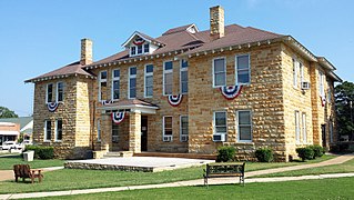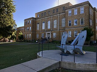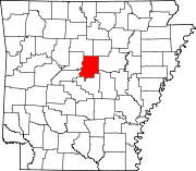
Stone County is located in the Ozark Mountains in the U.S. state of Arkansas. The county is named for rugged, rocky area terrain of the Ozarks. Created as Arkansas's 74th county on April 21, 1873, Stone County has two incorporated cities: Mountain View, the county seat and most populous city, and Fifty-Six. The county is also the site of numerous unincorporated communities and ghost towns.

Faulkner County is located in the Central Arkansas region of the U.S. state of Arkansas. As of the 2020 census, the population was 123,498, making it the fifth most populous of Arkansas's 75 counties. The county seat and largest city is Conway. Faulkner County was created on April 12, 1873, one of nine counties formed during Reconstruction, and is named for Sandford C. Faulkner, better known as Sandy Faulkner, a popular figure in the state at the time.

Cleburne County is a county located in the U.S. state of Arkansas. As of the 2020 census, the population was 24,711. The county seat and most populous city is Heber Springs. The county was formed on February 20, 1883, as the last of Arkansas's 75 counties to be formed. It is named for Confederate Major-General Patrick Cleburne. Cleburne is an alcohol prohibition or dry county.

Baxter County is a county in the U.S. state of Arkansas. As of the 2020 census, the county's population was 41,627. The county seat is Mountain Home. It is Arkansas's 66th county, formed on March 24, 1873, and named for Elisha Baxter, the tenth governor of Arkansas.

Arkansas Highway 25 is a northeast–southwest state highway in north central Arkansas. The route runs 85.66 miles (137.86 km) from US 64 in Conway to US 63/412 in Black Rock through Greers Ferry, Batesville, and the foothills of The Ozarks.

Highway 319 is a designation for two state highways in central Arkansas. The main segment runs 18.01 miles (28.98 km) from AR 38 in Ward to AR 107 south of Vilonia. A short segment runs 1.65 miles (2.66 km) from Cadron Settlement Park to US 64 in Conway.

Highway 89 is a highway in the central part of the U.S. state of Arkansas.

Interstate 40 (I-40) is an east–west Interstate Highway that has a 284.69-mile (458.16 km) section in the U.S. state of Arkansas, connecting Oklahoma to Tennessee. The route enters Arkansas from the west just north of the Arkansas River near Dora. It travels eastward across the northern portion of the state, connecting the cities of Fort Smith, Clarksville, Russellville, Morrilton, Conway, North Little Rock, Forrest City, and West Memphis. I-40 continues into Tennessee, heading through Memphis. The highway has major junctions with I-540 at Van Buren, I-49 at Alma, I-30 in North Little Rock, and I-55 to Blytheville.

Arkansas Highway 60 is a state highway that exists in five separate sections in Arkansas. The longest and most well-known segment of 54.19 miles (87.21 km) runs from Highway 28 in Plainview east to U.S. Route 65B (US 65B) in Conway. A segment in western Logan County of 2.64 miles (4.25 km) begins at the Old Highway 10 at the Sebastian County line and runs east to Highway 10. A third segment of 10.80 miles (17.38 km) begins at Highway 252 near Lavaca and runs east to Highway 41 at Peter Pender. A fourth segment runs 1.34 miles (2.16 km) from US 64 and runs across Interstate 40/Interstate 540 (I-40/I-540) to Highway 282. A fifth route of 2.34 miles (3.77 km) begins at Highway 282 near Rudy and runs north to County Road 23 (CR 23).

Arkansas Highway 266 is an east–west state highway in Faulkner County, Arkansas. The route of 0.87 miles (1.40 km) runs from U.S. Route 65 Business and U.S. Route 64 in Conway east to Siebenmorgen Road.

Arkansas Highway 124 is a designation for two state highways in Central Arkansas. The western segment of 72.17 miles (116.15 km) runs from Russellville to Rose Bud. An eastern segment of 9.17 miles (14.76 km) runs east in White County from Pangburn to AR 157.

Highway 285 is a designation for three north–south state highways in central Arkansas. One route of 6.17 miles (9.93 km) runs north from US Route 65 near Greenbrier to Woolly Hollow State Park in Faulkner County. A second route of 9.90 miles (15.93 km) begins at Highway 25 in Wooster and runs north to Highway 124 at Martinville, also in Faulkner County. A third segment runs north from US 65 in Damascus to Highway 92 at Rabbit Ridge in Van Buren County.
Woolly Hollow State Park is a 375-acre (152 ha) Arkansas state park in Faulkner County, near Greenbrier, Arkansas in the United States. The park was built and is based on a dam lake, Bennett Lake, built by the Civilian Conservation Corps (CCC) located at nearby Camp Halsey and Works Progress Administration (WPA) beginning in 1933. Access to the park is available from Arkansas Highway 285.

Arkansas Highway 107 is the name of multiple state highways in Arkansas.
South Side School District is a public school district based in Bee Branch, Arkansas, United States. The South Side School District provides early childhood, elementary and secondary education for more than 500 prekindergarten through grade 12 students at its two facilities within Van Buren County, Arkansas. The district is accredited by the Arkansas Department of Education (ADE). It also includes sections of Faulkner County.
Republican is an unincorporated community in Faulkner County, Arkansas, United States. The community is located along local roads in the northeast part of the county, 3.9 miles (6.3 km) northwest of Greenbrier.
Barney is an unincorporated community in Faulkner County, Arkansas, United States. The community is located along Arkansas Highway 107 3.9 miles (6.3 km) north of Enola.
Hamlet is an unincorporated community in Faulkner County, Arkansas, United States. The community is located at the junction of U.S. Route 64 and Arkansas Highway 36, about halfway between Conway and Vilonia along the former.
Springhill is an unincorporated community in Faulkner County, Arkansas, United States. The community is located at the junction of U.S. Route 65 and Arkansas Highway 287, 3 miles (4.8 km) south of Greenbrier.

Highway 310 is a designation for two state highways in Central Arkansas. One route of 13.40 miles (21.57 km) begins at Highway 36 and runs east to Highway 16. A second route of 11.01 miles (17.72 km) begins at Highway 5 and runs west to Faulkner County Route 310 (CR 310) Clinton Mountain Road west of Enola. All routes are maintained by the Arkansas Department of Transportation (ArDOT).


