Vilonia, Arkansas | |
---|---|
City | |
Drone Flyover, Welcome Sign, Veterans Memorial, Baseball Fields, Fire Department, Veterans Museum | |
Coordinates: 35°4′38″N92°12′45″W / 35.07722°N 92.21250°W | |
Country | United States |
State | Arkansas |
County | Faulkner |
Incorporated | 1938 |
Government | |
• Mayor | Preston Scroggins |
Area | |
• City | 7.98 sq mi (20.66 km2) |
• Land | 7.97 sq mi (20.65 km2) |
• Water | 0.00 sq mi (0.01 km2) |
Elevation | 312 ft (95 m) |
Population (2020) | |
• City | 4,288 |
• Density | 537.82/sq mi (207.66/km2) |
• Metro | 748,031 |
Time zone | UTC-6 (Central (CST)) |
• Summer (DST) | UTC-5 (CDT) |
ZIP code | 72173 |
Area code | 501 |
FIPS code | 05-71960 |
GNIS feature ID | 2405655 [2] |
Website | www |
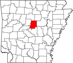
Vilonia is a city [3] in Faulkner County, Arkansas, United States. Its population was 4,288 in 2020 and estimated at 4,429 in 2021, [4] up from 3,815 at the 2010 census [5] and 2,106 at the 2000 census. It is part of the Central Arkansas region.
Vilonia was first settled in 1861 as Vilsonia. By 1870, a cottin gin, a gristmill, general stores and a drug store were in Vilsonia. In 1873, an error caused the town name to be changed to Vilonia.[ citation needed ]
In 1874, the first schoolhouse was built on what is now U.S. Highway 64. In 1879, the first post office was established. In 1887, a blacksmith shop was opened. In 1905, the Arkansas Holiness College was built in Vilonia. Sometime in the 1930s, the college closed and was burned. On August 23, 1938, Vilonia was incorporated under mayor Thomas H. Hill. [6]
A small portion of the town was destroyed by a tornado on the evening of April 25, 2011. The devastated area was a mobile home park. The tornado was confirmed and rated high-end EF2 by National Weather Service survey crews. Four people were killed in the Vilonia area. [7]
On April 27, 2014, in the late evening hours, a violent EF4 tornado passed through Mayflower and continued into Vilonia shortly before 7:50 p.m. (0050 UTC). 16 people were killed, several homes in one subdivision were swept clean off their foundations, a 15-ton fertilizer tank was thrown ¾ of a mile and several businesses were damaged or destroyed, including the new Vilonia Intermediate School, which had been set to open in the fall. The NWS office in Little Rock said that if it had occurred before the Enhanced Fujita scale was implemented in 2007, it would more than likely have been rated F5. There was consideration for upgrading the tornado to EF5 status, but due to the low quality of construction, the EF4 rating stands. [8]
On May 7, 2014, President Barack Obama visited the city to view the damage and reconstruction efforts. With him were Governor Mike Beebe (D), Senator Mark Pryor (D) and Representative Tim Griffin (R). [9]
Vilonia is located in southeastern Faulkner County at 35°4′38″N92°12′45″W / 35.07722°N 92.21250°W (35.077299, −92.212617). [10] It is bypassed to the south by US 64 which leads west 13 miles (21 km) to Conway, the county seat, and east 21 miles (34 km) to Beebe.
According to the United States Census Bureau, Vilonia has a total area of 7.1 square miles (18.4 km2), of which 0.004 square miles (0.01 km2), or 0.05%, is water. [5]
Census | Pop. | Note | %± |
---|---|---|---|
1940 | 259 | — | |
1950 | 215 | −17.0% | |
1960 | 234 | 8.8% | |
1970 | 423 | 80.8% | |
1980 | 736 | 74.0% | |
1990 | 1,133 | 53.9% | |
2000 | 2,106 | 85.9% | |
2010 | 3,815 | 81.1% | |
2020 | 4,288 | 12.4% | |
U.S. Decennial Census [11] |
Race | Number | Percentage |
---|---|---|
White (non-Hispanic) | 3,694 | 86.15% |
Black or African American (non-Hispanic) | 53 | 1.24% |
Native American | 32 | 0.75% |
Asian | 25 | 0.58% |
Pacific Islander | 2 | 0.05% |
Other/Mixed | 299 | 6.97% |
Hispanic or Latino | 183 | 4.27% |
At the 2020 United States census, there were 4,288 people, 1,432 households and 1,211 families residing in the city.
At the 2000 census, [13] there were 2,106 people, 726 households and 612 families residing in the town. The population density was 327.6 per square mile (126.5/km2). There were 785 housing units at an average density of 122.1 per square mile (47.1/km2). The racial make-up was 98.39% White, 0.14% Black or African American, 0.52% Native American, 0.19% Asian, 0.19% from other races and 0.57% from two or more races. 1.28% of the population were Hispanic or Latino of any race.
There were 726 households, of which 51.9% had children under the age of 18 living with them, 69.7% were married couples living together, 10.9% had a female householder with no husband present and 15.7% were non-families. 13.5% of all households were made up of individuals and 4.1% had someone living alone who was 65 years of age or older. The average household size was 2.90 and the average family size was 3.16.
33.0% of the population were under the age of 18, 7.2% from 18 to 24, 35.4% from 25 to 44, 16.6% from 45 to 64 and 7.9% were 65 years of age or older. The median age was 32 years. For every 100 females, there were 97.7 males. For every 100 females age 18 and over, there were 96.4 males.
The median household income was $45,147 and the median family income was $50,184. Males had a median income of $33,684 and females $26,563. The per capita income was $17,495. About 6.1% of families and 7.6% of the population were below the poverty line, including 9.0% of those under age 18 and 11.9% of those age 65 or over.
Public education of early childhood, elementary and secondary school students is primarily provided by the Vilonia School District, which leads to graduation from Vilonia High School.
Nearby secondary educational institutions include the Arkansas State University: Beebe Campus, Central Baptist College, Hendrix College, and University of Central Arkansas in Conway.
Sharkey County is a county located in the U.S. state of Mississippi. Part of the eastern border is formed by the Yazoo River. According to the 2020 census, the population was 3,800, making it the second-least populous county in Mississippi, after Issaquena County. Its county seat is Rolling Fork. The county is named after William L. Sharkey, the provisional Governor of Mississippi in 1865.
Baca County is a county located in the U.S. state of Colorado. As of the 2020 census, the population was 3,506. The county seat is Springfield. Located at the southeast corner of Colorado, the county shares state borders with Kansas, New Mexico, and Oklahoma.
White County is a county located in the U.S. state of Arkansas. As of the 2020 census, the population was 76,822. The county seat is Searcy. White County is Arkansas's 31st county, formed on October 23, 1835, from portions of Independence, Jackson, and Pulaski counties and named for Hugh Lawson White, a Whig candidate for President of the United States. It is an alcohol prohibition or dry county, though a few private establishments can serve alcohol.
Faulkner County is a county located in the Central Arkansas region of the U.S. state of Arkansas. As of the 2020 census, the population was 123,498, making it the fifth most populous of Arkansas's 75 counties. The county seat and largest city is Conway. Faulkner County was created on April 12, 1873, one of nine counties formed during Reconstruction, and is named for Sandford C. Faulkner, better known as Sandy Faulkner, a popular figure in the state at the time.
Harvest is an unincorporated community and census-designated place (CDP) in the northwestern part of Madison County, Alabama, United States, and is included in the Huntsville-Decatur Combined Statistical Area. According to the 2020 U.S. Census, the population of the community is 5,893.
Quitman is a city in Cleburne and Faulkner counties in the U.S. state of Arkansas. Its population was 762 at the 2010 census. The portion of the city in Faulkner County is part of the Central Arkansas region.
Monette is a city in Craighead County, Arkansas, United States. The city is located in an area of Northeast Arkansas known as Buffalo Island. The population was 1,506 at the 2020 census.
Mayflower is a city in Faulkner County, Arkansas, United States. The population was 2,234 at the 2010 census, up from 1,631 at the 2000 census. It is located in the Central Arkansas region.
Mount Vernon is a town in Faulkner County, Arkansas, United States. The population was 145 at the 2010 census. It is part of the Central Arkansas region.
Amagon is a town in Jackson County, Arkansas, United States. The population was 98 at the 2010 census. It is the birthplace of former Governor of Arkansas Mike Beebe.
Leachville is a city in Mississippi County, Arkansas, United States. The population was 2,039 at the 2020 census. Leachville was incorporated in 1916.
Clinton is the county seat of Van Buren County, Arkansas, United States. The population was 2,602 at the 2010 census, making it the most populous city in the county.
Beebe is a city in White County, Arkansas, United States. The population was 8,437 at the 2020 U.S. Census, making it the second most populous in the county. The city is home to Arkansas State University-Beebe. ASU-Beebe also has branch campuses in Heber Springs and Searcy and at Little Rock Air Force Base.
McRae is a city in White County, Arkansas, United States. The population was 682 at the 2010 census, estimated by 2018 to have decreased to 663 residents.
Lake Barrington is a village in Lake County, Illinois, United States. Per the 2020 census, the population was 5,100.
New Hartford is a city in Butler County, Iowa, United States. The population was 570 at the time of the 2020 census.
Chapman is a city in Dickinson County, Kansas, United States. As of the 2020 census, the population of the city was 1,377.
Atlanta is a village in Winn Parish, Louisiana, United States. The population was 163 at the 2010 census, and had been 150 in 2000.
Pilger is a village in Stanton County, Nebraska, United States. As of the 2010 census, the population was 352. It is located approximately 85 miles northwest of Omaha.
Northwood is a city in Grand Forks County, North Dakota, United States. It is part of the "Grand Forks, ND-MN Metropolitan Statistical Area" or "Greater Grand Forks." The population was 982 at the 2020 census.