Centreville, Centerville, Centre-ville or Centre-Ville and variants may refer to:
"Colonel" Sanford C. 'Sandy' Faulkner (1806–1874) was an American born March 3 in Scott County, Kentucky to his father Nicholas and mother Sally Fletcher Faulkner. He was a politician, teller of tall tales, fiddle player, and responsible in large part for the story forming the basis of the popular fiddle tune "The Arkansas Traveler", which was the State song of Arkansas from 1949 to 1963 and has been the state historical song since 1987.

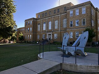
Central Arkansas, also known as the Little Rock metro, designated by the United States Office of Management and Budget as the Little Rock-North Little Rock-Conway Metropolitan Statistical Area, is the most populous metro area in the US state of Arkansas. With an estimated 2016 population of 734,622, it is the most populated area in Arkansas. Located at the convergence of Arkansas's other geographic regions, the region's central location make Central Arkansas an important population, economic, education, and political center in Arkansas and the South. Little Rock is the state's capital, and the city is also home to two Fortune 500 companies, Arkansas Children's Hospital, and University of Arkansas for Medical Sciences (UAMS).
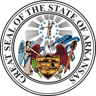
The Arkansas State Seal was adopted in 1864 and modified to its present form on May 23, 1907. The outer ring of the seal contains the text "Great Seal of the State of Arkansas". The inner seal contains the Angel of Mercy, the Sword of Justice and the Goddess of Liberty surrounded by a bald eagle. The eagle holds in its beak a scroll inscribed with the Latin phrase "Regnat Populus", the state motto, which means "The People Rule". On the shield of the seal are a steamboat, a plow, a beehive and a sheaf of wheat, symbols of Arkansas's industrial and agricultural wealth.
Centerville Township may refer to:
The Log Cabin Democrat is a daily newspaper in Conway, Arkansas, United States, serving Conway and Faulkner County and some surrounding areas. It was founded in July 1879 as The Log Cabin. Its publisher is Kelly Sublett.
Arkansas Highway 266 is an east–west state highway in Faulkner County, Arkansas. The route of 0.87 miles (1.40 km) runs from U.S. Route 65 Business and U.S. Route 64 in Conway east to Siebenmorgen Road.
Highway 285 is a designation for three north–south state highways in central Arkansas. One route of 6.17 miles (9.93 km) runs north from US Route 65 near Greenbrier to Woolly Hollow State Park in Faulkner County. A second route of 9.90 miles (15.93 km) begins at Highway 25 in Wooster and runs north to Highway 124 at Martinville, also in Faulkner County. A third segment runs north from US 65 in Damascus to Highway 92 at Rabbit Ridge in Van Buren County.

Wooly Hollow State Park is a 370-acre (150 ha) Arkansas state park in Faulkner County, near Greenbrier, Arkansas in the United States. The park was built and is based on a dam lake, Bennett Lake, built by the Civilian Conservation Corps (CCC) and Works Progress Administration (WPA) beginning in 1933. Access to the park is available from Arkansas Highway 285.

Arkansas Highway 107 is the name of multiple state highways in Arkansas.

Harps Food Stores, Inc., based in Springdale, Arkansas, is a chain of 91 supermarkets located across Arkansas, Oklahoma, Missouri, and Kansas. The company sells both groceries and sporting goods in some larger stores. They also operate stores under the Food4Less and 10-Box Banner. Harps Food Stores was founded in 1930 by Harvard and Floy Harp. In 2001, Harps became employee-owned after buying company shares from the Harp family. The stores are supplied by Kansas City, Kansas based Associated Wholesale Grocers. The company is valued around $550 million, and employed 4,450 people in 2017.
Centerville, Arkansas may refer to:
Centerville is an unincorporated community in Yell County, Arkansas, United States. Centerville is located at the junction of Arkansas Highways 7 and 154, 6.5 miles (10.5 km) north-northeast of Ola. Centerville has a post office with ZIP code 72829.
Centerville is an unincorporated community in Jackson County, Arkansas, United States. Centerville is located near the Black River, 6 miles (9.7 km) north-northwest of Tuckerman.
Centerville is an unincorporated community in Hempstead County, Arkansas, United States. Centerville is located on U.S. Route 278, 6 miles (9.7 km) east-southeast of Hope.

Arkansas Highway 154 is a 41.00-mile (65.98 km) east-west state highway in the western portion of the U.S. state of Arkansas. The highway begins at Arkansas Highway 27 in Yell County northeast of Danville and runs east to Arkansas Highway 113 in Conway County east of Oppelo. Highway 154 is maintained by the Arkansas State Highway and Transportation Department.

The Blessing Homestead is a historic farmstead in rural northeastern Faulkner County, Arkansas. It is located overlooking the west bank of East Fork Cadron Creek, on Happy Valley Road east of County Road 225E, between McGintytown and Centerville. The central feature of the homestead is a dogtrot house, with one pen built of logs and the other of wood framing. The log pen was built about 1872, and typifies the evolutionary growth of these kinds of structures. It is the only remaining structure associated with the early history of Barney, most of which was wiped out by a tornado in 1915.

The Hardy Cemetery is a historic cemetery at 722 Arkansas Highway 225 East in Centerville, Faulkner County, Arkansas. It is set on 3 acres (1.2 ha) fringed by cedar trees. It consists of six barrel-vaulted tombs, all built to house members of the Hardy family, whose patriarch, Dr. Henry Baxton Hardy, was a prominent local doctor and politician. Only three of the tombs are occupied, by Dr. Hardy, his wife Cora, and Marco, one of his seven children. The others remained unoccupied due a rift in family relations.

Highway 310 is a designation for two state highways in Central Arkansas. One route of 13.40 miles (21.57 km) begins at Highway 36 and runs east to Highway 16. A second route of 11.01 miles (17.72 km) begins at Highway 5 and runs west to Faulkner County Route 310 (CR 310) Clinton Mountain Road west of Enola. All routes are maintained by the Arkansas Department of Transportation (ArDOT).