Faulkner County, Arkansas

Last updated

Faulkner County
FaulknerCountyCourthouse.jpg
Faulkner County Courthouse
Flag of Faulkner County, Arkansas.svg
Faulkner County, Arkansas official seal.png
Map of Arkansas highlighting Faulkner County.svg
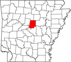
Location within the U.S. state of Arkansas
Arkansas in United States.svg
Arkansas's location within the U.S.
Coordinates: 35°09′36″N92°18′49″W / 35.16°N 92.3136°W / 35.16; -92.3136
CountryFlag of the United States.svg United States
StateFlag of Arkansas.svg  Arkansas
FoundedApril 12, 1873
Named for Sandford C. Faulkner
Seat Conway
Largest cityConway
Area
  Total664 sq mi (1,720 km2)
  Land648 sq mi (1,680 km2)
  Water16 sq mi (40 km2)  2.4%
Population
 (2020)
  Total123,498
  Density190/sq mi (72/km2)
Time zone UTC−6 (Central)
  Summer (DST) UTC−5 (CDT)
Congressional district 2nd
Website www.faulknercounty.org

Faulkner County is located in the Central Arkansas region of the U.S. state of Arkansas. As of the 2020 census, the population was 123,498, making it the fifth most populous of Arkansas's 75 counties. [1] The county seat and largest city is Conway. [2] Faulkner County was created on April 12, 1873, one of nine counties formed during Reconstruction, and is named for Sandford C. Faulkner, better known as Sandy Faulkner, a popular figure in the state at the time.

Contents

Located at the intersection of the Ozarks and Arkansas River Valley, the county was sparsely populated for much of its early years. Largely a county of rural settlements, growth came slowly following the Civil War and Reconstruction. The college known today as University of Central Arkansas was established in 1907, but population continued to grow slowly. The growth of Little Rock and the construction of Interstate 40 have made Conway and other parts of Faulkner County into bedroom communities for the state capitol. Today Faulkner County is included in the Central Arkansas metro area, with Conway as a principal city.

History

Eponym

Faulkner County was formed from parts of Conway and Pulaski counties on April 12, 1873, and is named after Sandford C. Faulkner, a planter, raconteur, and fiddle player known for his popular folk tale Arkansas Traveler (folklore) from the early-19th century. [3] The story later was performed by Mose Case in the mid-19th century as a folk song "Arkansas Traveler", the official historic song of the U.S. state of Arkansas since 1987. [4]

Geography

Lake Conway Lake Conway, Faulkner County, AR.jpg
Lake Conway

According to the U.S. Census Bureau, the county has a total area of 664 square miles (1,720 km2), of which 648 square miles (1,680 km2) is land and 16 square miles (41 km2) (2.4%) is water. [5]

Major highways

Transit

Adjacent counties

Demographics

Historical population
CensusPop.Note
1880 12,786
1890 18,34243.5%
1900 20,78013.3%
1910 23,70814.1%
1920 27,68116.8%
1930 28,3812.5%
1940 25,880−8.8%
1950 25,289−2.3%
1960 24,303−3.9%
1970 31,57229.9%
1980 46,19246.3%
1990 60,00629.9%
2000 86,01443.3%
2010 113,23731.6%
2020 123,4989.1%
2023 (est.)129,951 [6] 5.2%
U.S. Decennial Census [7]
1790–1960 [8] 1900–1990 [9]
1990–2000 [10] 2010 [11]
Age pyramid Faulkner County USA Faulkner County, Arkansas age pyramid.svg
Age pyramid Faulkner County

2020 census

Faulkner County racial composition [13]
RaceNumberPercentage
White (non-Hispanic)92,57374.96%
Black or African American (non-Hispanic)14,27411.56%
Native American 5620.46%
Asian 1,4611.18%
Pacific Islander 610.05%
Other/Mixed 7,7776.3%
Hispanic or Latino 6,7905.5%

As of the 2020 United States census, there were 123,498 people, 47,389 households, and 31,590 families residing in the county.

2000 census

As of the 2000 United States Census, [14] there were 86,014 people, 31,882 households, and 22,444 families residing in the county. The population density was 133 inhabitants per square mile (51/km2). There were 34,546 housing units at an average density of 53 per square mile (20/km2). The racial makeup of the county was 88.33% White, 8.48% Black or African American, 0.52% Native American, 0.72% Asian, 0.03% Pacific Islander, 0.68% from other races, and 1.23% from two or more races. 1.75% of the population were Hispanic or Latino of any race.

There were 31,882 households, out of which 35.70% had children under the age of 18 living with them, 56.70% were married couples living together, 10.20% had a female householder with no husband present, and 29.60% were non-families. 22.50% of all households were made up of individuals, and 6.90% had someone living alone who was 65 years of age or older. The average household size was 2.57 and the average family size was 3.04.

In the county, the population was spread out, with 25.60% under the age of 18, 15.30% from 18 to 24, 30.10% from 25 to 44, 19.50% from 45 to 64, and 9.50% who were 65 years of age or older. The median age was 31 years. For every 100 females, there were 95.50 males. For every 100 females age 18 and over, there were 92.30 males.

The median income for a household in the county was $38,204, and the median income for a family was $45,946. Males had a median income of $32,288 versus $24,428 for females. The per capita income for the county was $35,159. [15] About 7.90% of families and 12.50% of the population were below the poverty line, including 12.90% of those under age 18 and 12.00% of those age 65 or over.

Government

Over the past few election cycles Faulkner county has trended heavily towards the GOP. The last Democrat (as of 2020) to carry this county was Arkansas native Bill Clinton in 1996.

United States presidential election results for Faulkner County, Arkansas [16]
Year Republican Democratic Third party
No.%No.%No.%
2020 34,42163.24%18,34733.71%1,6603.05%
2016 29,34661.75%14,62930.78%3,5527.47%
2012 26,72264.45%13,62132.85%1,1172.69%
2008 25,36261.59%14,95536.32%8622.09%
2004 21,51458.64%14,53839.63%6341.73%
2000 16,05554.95%11,95040.90%1,2114.14%
1996 10,17842.19%12,03249.88%1,9137.93%
1992 9,49137.64%13,00051.56%2,72410.80%
1988 10,67858.42%7,30239.95%2991.64%
1984 11,59560.89%7,16937.65%2791.47%
1980 7,54444.19%8,52849.95%1,0015.86%
1976 3,90425.44%11,42374.45%160.10%
1972 6,74659.44%4,60440.56%00.00%
1968 2,79125.55%3,75634.39%4,37540.06%
1964 3,25934.61%6,11664.95%420.45%
1960 2,42636.71%3,82057.80%3635.49%
1956 2,39940.94%3,42858.50%330.56%
1952 1,99536.47%3,46163.27%140.26%
1948 62617.40%2,65373.76%3188.84%
1944 89727.69%2,33272.00%100.31%
1940 51916.93%2,53582.68%120.39%
1936 51116.79%2,52182.82%120.39%
1932 43713.48%2,74984.77%571.76%
1928 99227.07%2,65972.57%130.35%
1924 53625.14%1,43667.35%1607.50%
1920 1,14835.31%1,97160.63%1324.06%
1916 81728.69%2,03171.31%00.00%
1912 40220.20%1,31666.13%27213.67%
1908 74028.00%1,77167.01%1324.99%
1904 76440.06%1,07356.27%703.67%
1900 68235.69%1,19162.32%381.99%
1896 55621.27%2,04478.19%140.54%
1892 1,20039.74%1,49949.64%32110.63%

Education

Public education

Publicly funded education for elementary and secondary school students is provided by:

Private education

Privately funded education for elementary and secondary school students is provided by:

Communities

Cities

Towns

Townships

Townships in Faulkner County, Arkansas as of 2010 Faulkner County Arkansas 2010 Township Map large.jpg
Townships in Faulkner County, Arkansas as of 2010

Townships in Arkansas are the divisions of a county. Each township includes unincorporated areas; some may have incorporated cities or towns within part of their boundaries. Arkansas townships have limited purposes in modern times. However, the United States census does list Arkansas population based on townships (sometimes referred to as "county subdivisions" or "minor civil divisions"). Townships are also of value for historical purposes in terms of genealogical research. Each town or city is within one or more townships in an Arkansas county based on census maps and publications. The townships of Faulkner County are listed below; listed in parentheses are the cities, towns, and/or census-designated places that are fully or partially inside the township. [17] [18]

Source: [19]

See also

Related Research Articles

<span class="mw-page-title-main">White County, Arkansas</span> County in Arkansas, United States

White County is a county located in the U.S. state of Arkansas. As of the 2020 census, the population was 76,822. The county seat is Searcy. White County is Arkansas's 31st county, formed on October 23, 1835, from portions of Independence, Jackson, and Pulaski counties and named for Hugh Lawson White, a Whig candidate for President of the United States. It is an alcohol prohibition or dry county, though a few private establishments can serve alcohol.

<span class="mw-page-title-main">Van Buren County, Arkansas</span> County in Arkansas, United States

Van Buren County is a county located in the U.S. state of Arkansas. As of the 2020 census, the population was 15,796. The county seat is Clinton. The county was formed on November 11, 1833, and named for Martin Van Buren, President of the United States, who was Vice President at the time of the county's formation. Van Buren County was a dry county until November 3, 2020, as the county residents voted to make it a wet county.

<span class="mw-page-title-main">Polk County, Arkansas</span> County in Arkansas, United States

Polk County is a county located in the U.S. state of Arkansas. As of the 2020 census, the population was 19,221. The county seat is Mena. Polk County is Arkansas's 48th county, formed on November 30, 1844; it was named for James K. Polk, 11th President of the United States.

<span class="mw-page-title-main">Perry County, Arkansas</span> County in Arkansas, United States

Perry County is a county located in the U.S. state of Arkansas. Its population was 10,019 at the 2020 United States Census. The county seat is Perryville. The county was formed on December 18, 1840, and named for Commodore Oliver Hazard Perry, naval hero in the War of 1812. It is an alcohol prohibition or dry county.

<span class="mw-page-title-main">Lonoke County, Arkansas</span> County in Arkansas, United States

Lonoke County is located in the Central Arkansas region of the U.S. state of Arkansas. As of the 2020 census, the population was 74,015, making it the 10th-most populous of Arkansas's 75 counties. The county seat is Lonoke and largest city is Cabot. Included in the Central Arkansas metropolitan area, with Little Rock as the principal city, it is an alcohol prohibition or dry county.

<span class="mw-page-title-main">Lawrence County, Arkansas</span> County in Arkansas, United States

Lawrence County is a county located in the U.S. state of Arkansas. As of the 2020 census, the population was 16,216. The county seat is Walnut Ridge. Lawrence County is Arkansas's second county, formed on January 15, 1815, and named for Captain James Lawrence who fought in the War of 1812. It is an alcohol prohibition or dry county.

<span class="mw-page-title-main">Independence County, Arkansas</span> County in Arkansas, United States

Independence County is a county located in the U.S. state of Arkansas. As of the 2020 census, the population was 37,938. The county seat is Batesville. Independence County is Arkansas's ninth county, formed on October 20, 1820, from a portion of Lawrence County and named in commemoration of the Declaration of Independence. It is an alcohol prohibition or dry county.

<span class="mw-page-title-main">Conway County, Arkansas</span> County in Arkansas, United States

Conway County is a county located in the U.S. state of Arkansas. Created as Arkansas's 11th county on October 20, 1825, Conway County has four incorporated municipalities, including Morrilton, the county seat and most populous city. The county is also the site of numerous unincorporated communities and ghost towns. The county is named for Henry Wharton Conway, a politician from a powerful political family who served as the delegate from the Arkansas Territory to the U.S. Congress from 1823 to 1827.

<span class="mw-page-title-main">Cleburne County, Arkansas</span> County in Arkansas, United States

Cleburne County is a county located in the U.S. state of Arkansas. As of the 2020 census, the population was 24,711. The county seat and most populous city is Heber Springs. The county was formed on February 20, 1883, as the last of Arkansas's 75 counties to be formed. It is named for Confederate Major-General Patrick Cleburne. Cleburne is an alcohol prohibition or dry county.

<span class="mw-page-title-main">Quitman, Arkansas</span> City in Arkansas, United States

Quitman is a city in Cleburne and Faulkner counties in the U.S. state of Arkansas. Its population was 762 at the 2010 census. The portion of the city in Faulkner County is part of the Central Arkansas region.

<span class="mw-page-title-main">Enola, Arkansas</span> Town in Arkansas, United States

Enola is a town in Faulkner County, Arkansas, United States. It is part of the Central Arkansas region. The population was 318 at the 2020 census.

<span class="mw-page-title-main">Greenbrier, Arkansas</span> City in Arkansas, United States

Greenbrier is a city in Faulkner County, Arkansas, United States. It is part of the Central Arkansas region. The population was 5,707 at the 2020 census, up from 4,706 at the 2010 census.

<span class="mw-page-title-main">Guy, Arkansas</span> City in Arkansas, United States

Guy is a city in Faulkner County, Arkansas, United States. The population was 708 at the 2010 census, up from 202 at the 2000 census. It is part of the Central Arkansas region.

<span class="mw-page-title-main">Mayflower, Arkansas</span> City in Arkansas, United States

Mayflower is a city in Faulkner County, Arkansas, United States. The population was 2,234 at the 2010 census, up from 1,631 at the 2000 census. It is located in the Central Arkansas region.

<span class="mw-page-title-main">Mount Vernon, Arkansas</span> City in Arkansas, United States

Mount Vernon is a town in Faulkner County, Arkansas, United States. The population was 145 at the 2010 census. It is part of the Central Arkansas region.

<span class="mw-page-title-main">Twin Groves, Arkansas</span> Town in Arkansas, United States

Twin Groves is a town in northwestern Faulkner County, Arkansas, United States. The name of the town comes from two neighboring communities — Solomon Grove and Zion Grove — which joined to incorporate as a town in 1991. The town's population was 335 at the 2010 census, up from 276 at the 2000 census. Twin Groves is part of the Central Arkansas region.

<span class="mw-page-title-main">Vilonia, Arkansas</span> City in Arkansas, United States

Vilonia is a city in Faulkner County, Arkansas, United States. Its population was 4,288 in 2020 and estimated at4,429 in 2021, up from 3,815 at the 2010 census and 2,106 at the 2000 census. It is part of the Central Arkansas region.

<span class="mw-page-title-main">Wooster, Arkansas</span> City in Arkansas, United States

Wooster is a city in Faulkner County, Arkansas, United States. The population was 860 at the 2010 census, up from 516 at the 2000 census. It is part of the Central Arkansas region.

<span class="mw-page-title-main">Central Arkansas</span> Metropolitan area in Arkansas, United States

Central Arkansas, also known as the Little Rock metro, designated by the United States Office of Management and Budget as the Little Rock-North Little Rock-Conway Metropolitan Statistical Area, is the most populous metro area in the U.S. state of Arkansas. With an estimated 2020 population of 748,031, it is the most populated area in Arkansas. Located at the convergence of Arkansas's other geographic regions, the region's central location make Central Arkansas an important population, economic, education, and political center in Arkansas and the South. Little Rock is the state's capital and largest city, and the city is also home to two Fortune 500 companies, Arkansas Children's Hospital, and University of Arkansas for Medical Sciences (UAMS).

Mount Vernon–Enola School District 19 (MVESD) is a public school district based in Mount Vernon, Arkansas. MVESD supports more than 500 students in kindergarten through grade 12 and employs more than 90 faculty and staff on a full time equivalent basis for its two schools.

References

  1. "Census - Geography Profile: Faulkner County, Arkansas". United States Census Bureau . Retrieved January 19, 2023.
  2. "Find a County". National Association of Counties. Archived from the original on May 31, 2011. Retrieved June 7, 2011.
  3. Pope, William F. (1895). Early Days in Arkansas: Being for the Most Part the Personal Recollections of an Old Settler. F. W. Allsopp. pp. 230–233. ISBN   978-0-89308-071-6.
  4. Gannett, Henry (1905). The Origin of Certain Place Names in the United States. Govt. Print. Off. p. 124.
  5. "2010 Census Gazetteer Files". United States Census Bureau. August 22, 2012. Retrieved August 26, 2015.
  6. "Annual Estimates of the Resident Population for Counties: April 1, 2020 to July 1, 2023". United States Census Bureau. Retrieved March 30, 2024.
  7. "U.S. Decennial Census". United States Census Bureau. Retrieved August 26, 2015.
  8. "Historical Census Browser". University of Virginia Library. Archived from the original on August 11, 2012. Retrieved August 26, 2015.
  9. Forstall, Richard L., ed. (March 27, 1995). "Population of Counties by Decennial Census: 1900 to 1990". United States Census Bureau. Retrieved August 26, 2015.
  10. "Census 2000 PHC-T-4. Ranking Tables for Counties: 1990 and 2000" (PDF). United States Census Bureau. April 2, 2001. Archived (PDF) from the original on March 27, 2010. Retrieved August 26, 2015.
  11. "State & County QuickFacts". United States Census Bureau. Archived from the original on June 7, 2011. Retrieved May 20, 2014.
  12. Based on 2000 census data
  13. "Explore Census Data". data.census.gov. Retrieved December 31, 2021.
  14. "U.S. Census website". United States Census Bureau . Retrieved May 14, 2011.
  15. "Local Area Personal Incomes". Bureau of Economic Analysis. Bureau of Economic Analysis. Retrieved February 6, 2018.
  16. "Dave Leip's Atlas of U.S. Presidential Elections" . Retrieved December 22, 2020.
  17. 2011 Boundary and Annexation Survey (BAS): Faulkner County, AR (PDF) (Map). U. S. Census Bureau. Archived from the original (PDF) on October 19, 2012. Retrieved August 4, 2011.
  18. "Arkansas: 2010 Census Block Maps - County Subdivision". United States Census Bureau . Retrieved May 28, 2014.
  19. "Summary Population and Housing Characteristics, CPH-1-5, Arkansas" (PDF). 2010 Census of Population and Housing. United States Census Bureau. September 2012. Retrieved May 31, 2014.

35°09′36″N92°18′49″W / 35.16000°N 92.31361°W / 35.16000; -92.31361