Stone County, Arkansas

Last updated

Stone County
Stone County Courthouse 001.jpg
Stone County courthouse in Mountain View
Map of Arkansas highlighting Stone County.svg
Location within the U.S. state of Arkansas
Arkansas in United States.svg
Arkansas's location within the U.S.
Coordinates: 35°52′46″N92°08′50″W / 35.879444444444°N 92.147222222222°W / 35.879444444444; -92.147222222222
CountryFlag of the United States.svg United States
StateFlag of Arkansas.svg  Arkansas
FoundedApril 21, 1873
Named for rock formations in the area [1]
Seat Mountain View
Largest cityMountain View
Area
[2]
  Total609.43 sq mi (1,578.4 km2)
  Land606.59 sq mi (1,571.1 km2)
  Water2.84 sq mi (7.4 km2)  0.5%
Population
 (2020)
  Total12,359
  Density20/sq mi (7.8/km2)
Time zone UTC−6 (Central)
  Summer (DST) UTC−5 (CDT)
Congressional district 1st

Stone County is located in the Ozark Mountains in the U.S. state of Arkansas. The county is named for rugged, rocky area terrain of the Ozarks. Created as Arkansas's 74th county on April 21, 1873, Stone County has two incorporated cities: Mountain View, the county seat and most populous city, and Fifty-Six. The county is also the site of numerous unincorporated communities and ghost towns.

Contents

Most of the county is sparsely populated forested Ozark hills; including the northern fifth of the county managed by the United States Forest Service as the Ozark National Forest. The remainder of the county is used for poultry, ranching, and timber production. The White River runs along the eastern boundary of Stone County. The county contains six protected areas in addition to the Ozark National Forest: Blanchard Springs Caverns within the Ozark National Forest, two Natural Areas, two Wildlife Management Areas and the Ozark Folk Center, which preserves and interprets Ozark cultural heritage, especially traditional mountain folk music and crafts. Other features such as log cabins, one-room school houses, community centers, and museums, as well as annual cultural events, preserve the history and culture of Stone County.

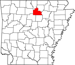
Stone County occupies 609.43 square miles (1,578.4 km2) and contained a population of 12,359 as of the 2020 Census. [3]

Geography

Stone County is located in the Ozark Mountains, one of the six ecoregions of Arkansas. The Ozarks are a mountainous subdivision of the U.S. Interior Highlands, and Stone County contains the Springfield Plateau, Salem Plateau, and the relatively steeper Boston Mountains subsets. The county is roughly split along an east–west line near Mountain View, the centrally located county seat, [4] with areas north within the Springfield Plateau, and areas south within the Boston Mountains. Areas along the White River, which forms the county's northeastern boundary, are dissected bluffs of the Salem Plateau rather than riparian floodplains. [5] According to the U.S. Census Bureau, the county has a total area of 609.43 square miles (1,578.4 km2), of which 606.59 square miles (1,571.1 km2) is land and 2.84 square miles (7.4 km2) (0.5%) is water. [2]

The county is located approximately 105 miles (169 km) north of Little Rock, 151 miles (243 km) northwest of Memphis, Tennessee, and 278 miles (447 km) southwest of St. Louis, Missouri. [Note 1] Stone County is surrounded by three Ozark counties, Searcy County to the west, Baxter County to the northwest, Izard County to the northeast, and three border counties with the Arkansas River Valley, Van Buren County to the southwest, Cleburne County to the south, and Independence County (which also contains a small piece of the Arkansas Delta) to the east.

Hydrology

National protected area

Demographics

Historical population
CensusPop.Note
1880 5,089
1890 7,04338.4%
1900 8,10015.0%
1910 8,94610.4%
1920 8,779−1.9%
1930 7,993−9.0%
1940 8,6037.6%
1950 7,662−10.9%
1960 6,294−17.9%
1970 6,8388.6%
1980 9,02231.9%
1990 9,7758.3%
2000 11,49917.6%
2010 12,3947.8%
2020 12,359−0.3%
2023 (est.)12,671 [7] 2.5%
U.S. Decennial Census [8]
1790–1960 [9] 1900–1990 [10]
1990–2000 [11] 2010 [12]

2020 Census

Stone County racial composition [13]
RaceNumberPercentage
White (non-Hispanic)11,38792.14%
Black or African American (non-Hispanic)210.17%
Native American 870.7%
Asian 250.2%
Pacific Islander 20.02%
Other/Mixed 5664.58%
Hispanic or Latino 2712.19%

As of the 2020 United States census, there were 12,359 people, 4,787 households, and 3,109 families residing in the county.

2010 Census

As of the 2010 census, [14] there were 12,394 people, 5,325 households, and 3,590 families residing in the county. The population density was 20 people per square mile (7.7 people/km2). There were 6,712 housing units at an average density of 11 units per square mile (4.2 units/km2). The racial makeup of the county was 96.8% White, 0.1% Black or African American, 0.7% Native American, 0.4% Asian, 0.0% Pacific Islander, 0.4% from other races, and 1.6% from two or more races. 1.3% of the population were Hispanic or Latino of any race.

There were 5,325 households, out of which 26.0% had children under the age of 18 living with them, 67.4% were married couples living together, 7.2% had a female householder with no husband present, and 32.6% were non-families. 28.9% of all households were made up of individuals, and 36.6% had someone living alone who was 65 years of age or older. The average household size was 2.30 and the average family size was 2.81.

In the county, the population was spread out, with 20.6% under the age of 18, 6.2% from 18 to 24, 19.4% from 25 to 44, 31.0% from 45 to 64, and 22.8% who were 65 years of age or older. The median age was 37.2 years. For every 100 females there were 97.8 males. For every 100 females age 18 and over, there were 96.2 males.

The median income for a household in the county was $30,380, and the median income for a family was $36,765. [15] Males had a median income of $28,258 versus $25,341 for females. [16] The per capita income for the county was $16,090. About 16.6% of families and 23.4% of the population were below the poverty line, including 35.7% of those under age 18 and 20.6% of those age 65 or over. [17]

2000 Census

Age pyramid Stone County USA Stone County, Arkansas age pyramid.svg
Age pyramid Stone County

As of the 2000 census, [19] there were 11,499 people, 4,768 households, and 3,461 families residing in the county. The population density was 19 people per square mile (7.3 people/km2). There were 5,715 housing units at an average density of 9 units per square mile (3.5 units/km2). The racial makeup of the county was 97.27% White, 0.08% Black or African American, 0.77% Native American, 0.05% Asian, 0.03% Pacific Islander, 0.15% from other races, and 1.64% from two or more races. 1.08% of the population were Hispanic or Latino of any race.

There were 4,768 households, out of which 26.90% had children under the age of 18 living with them, 62.30% were married couples living together, 7.10% had a female householder with no husband present, and 27.40% were non-families. 24.80% of all households were made up of individuals, and 11.20% had someone living alone who was 65 years of age or older. The average household size was 2.38 and the average family size was 2.82.

In the county, the population was spread out, with 22.20% under the age of 18, 7.10% from 18 to 24, 23.60% from 25 to 44, 28.50% from 45 to 64, and 18.60% who were 65 years of age or older. The median age was 43 years. For every 100 females there were 96.90 males. For every 100 females age 18 and over, there were 95.30 males.

The median income for a household in the county was $22,209, and the median income for a family was $28,009. Males had a median income of $20,904 versus $16,118 for females. The per capita income for the county was $14,134. About 14.10% of families and 18.90% of the population were below the poverty line, including 26.20% of those under age 18 and 12.10% of those age 65 or over.

Culture and contemporary life

Built c. 1930, the Luber School is one of many period structures built using the stone for which the county is named Luber School.jpg
Built c.1930, the Luber School is one of many period structures built using the stone for which the county is named

Media

The county newspaper is the Stone County Leader , a weekly published in Mountain View since 1952. Former newspapers include the Stone County Democrat and Mountain View Herald (1932-1953). Mountain View has also produced several short-lived publications, including the Mountain View News (1905-1906), The Mountain View (1973-1974), and The Ozark Times (1906-1913).

The Stone County Historical Society has published the Heritage of Stone since 1972. Issued twice annually to members and available to the public for individual purchase, the publication covers topics relating to the history and culture of Stone County.

Government

The Stone County Courthouse has been the seat of county government since 1922. Stone County Courthouse 001.jpg
The Stone County Courthouse has been the seat of county government since 1922.

The county government is a constitutional body granted specific powers by the Constitution of Arkansas and the Arkansas Code. The quorum court is the legislative branch of the county government and controls all spending and revenue collection. Representatives are called justices of the peace and are elected from county districts every even-numbered year. The number of districts in a county vary from nine to fifteen, and district boundaries are drawn by the county election commission. The Stone County Quorum Court has nine members. [1] Presiding over quorum court meetings is the county judge, who serves as the chief operating officer of the county. The county judge is elected at-large and does not vote in quorum court business, although capable of vetoing quorum court decisions. [20] [21]

Taxation

Property tax is assessed by the Stone County Assessor annually based upon the fair market value of the property and determining which tax rate, commonly called a millage in Arkansas, will apply. The rate depends upon the property's location with respect to city limits, school district, and special tax increment financing (TIF) districts. This tax is collected by the Stone County Collector between the first business day of March of each year through October 15 without penalty. The Stone County Treasurer disburses tax revenues to various government agencies, such as cities, county road departments, fire departments, libraries, and police departments in accordance with the budget set by the quorum court.

Sales and use taxes in Arkansas are voter approved and collected by the Arkansas Department of Finance and Administration. Arkansas's statewide sales and use tax has been 6.5% since July 1, 2013. [22] Stone County has an additional sales and use tax of 1%, which has been in effect since May 1, 1987. Within Stone County, the City of Mountain View has had an additional 2% sales and use tax since September 1, 2005. [23] The Arkansas State Treasurer disburses state tax revenue to counties/cities in accordance with tax rules.

Politics

In Congress, Arkansas has been represented by two Republican senators (John Boozman and Tom Cotton) since January 3, 2015, ending a long history of Democratic hegemony. In the House of Representatives, Stone County is within the Arkansas 1st district, which contains the Arkansas Delta. The Arkansas 1st has been represented by Rick Crawford since 2010.

In the Arkansas Senate, Stone County is within the 18th District, which also contains all of Cleburne and Searcy counties and parts of Faulkner, Fulton, Baxter, Marion, Van Buren, and White counties. [24] The 18th District has been represented by Missy Irvin (R) of Mountain View since 2011.

United States presidential election results for Stone County, Arkansas [25]
Year Republican Democratic Third party
No.%No.%No.%
2020 4,61677.74%1,18019.87%1422.39%
2016 4,11373.21%1,20321.41%3025.38%
2012 3,77670.53%1,35625.33%2224.15%
2008 3,53466.38%1,59830.02%1923.61%
2004 3,18857.45%2,25540.64%1061.91%
2000 2,62353.97%2,04342.04%1943.99%
1996 1,52634.36%2,22750.15%68815.49%
1992 1,67233.18%2,62252.03%74514.78%
1988 2,18655.17%1,72843.61%481.21%
1984 2,32557.48%1,65440.89%661.63%
1980 1,79345.11%1,96849.51%2145.38%
1976 1,01427.06%2,71872.54%150.40%
1972 1,98967.38%95832.45%50.17%
1968 98737.05%69826.20%97936.75%
1964 94240.26%1,37458.72%241.03%
1960 95949.36%89746.17%874.48%
1956 65146.14%75653.58%40.28%
1952 70054.95%57344.98%10.08%
1948 64433.56%1,18661.80%894.64%
1944 54947.57%59251.30%131.13%
1940 40638.41%64460.93%70.66%
1936 24832.12%52167.49%30.39%
1932 26118.78%1,10079.14%292.09%
1928 49943.62%62854.90%171.49%
1924 21032.31%38659.38%548.31%
1920 36739.25%51655.19%525.56%
1916 29830.41%68269.59%00.00%
1912 11318.46%33755.07%16226.47%
1908 26733.33%49661.92%384.74%
1904 23343.15%27751.30%305.56%
1900 23130.28%52068.15%121.57%
1896 17218.96%72880.26%70.77%

Communities

Two incorporated cities are located within the county. The largest city and county seat, Mountain View, is relatively centrally located in the oddly-shaped county. Mountain View's population in 2010 was 2,748, marking the first decennial decline since the 1960 Census. Fifty-Six has maintained a stable population under 200 since incorporation. [4]

Stone County has dozens of unincorporated communities and ghost towns within its borders. This is due to early settlers in Arkansas tending to settle in small clusters rather than incorporated towns. For example, communities like Newnata had a post office and dozens of buildings at some point in their history. Other communities are simply a few dwellings at a crossroads that have adopted a common place name over time. Some are officially listed as populated places by the United States Geological Survey, and others are listed as historic settlements.

Cities

Unincorporated communities

Historical communities

Townships

Townships in Stone County, Arkansas as of 2010 Stone County Arkansas 2010 Township Map large.jpg
Townships in Stone County, Arkansas as of 2010

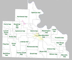
Townships in Arkansas are the divisions of a county. Each township includes unincorporated areas; some may have incorporated cities or towns within part of their boundaries. Arkansas townships have limited purposes in modern times. However, the United States census does list Arkansas population based on townships (sometimes referred to as "county subdivisions" or "minor civil divisions"). Townships are also of value for historical purposes in terms of genealogical research. Each town or city is within one or more townships in an Arkansas county based on census maps and publications. The townships of Stone County are listed below; listed in parentheses are the cities, towns, and/or census-designated places that are fully or partially inside the township. [26] [27]

  • Arbana (small part of Mountain View)
  • Blue Mountain (most of Mountain View)
  • Bryan
  • Farris
  • Flag
  • Franklin
  • Harris (small part of Mountain View)
  • Jones
  • Liberty
  • Locust Grove
  • Marcella
  • Northwest (Fifty-Six)
  • Optimus
  • Red River
  • Red Stripe
  • Richwoods
  • Roasting Ear
  • Smart
  • Sylamore
  • Timbo
  • Turkey Creek
  • Union
  • Washington
  • Wilson

Infrastructure

Aviation

Mountain View Airport is the only public owned/public use airport in Stone County. Also known as Harry E. Wilcox Memorial Field, the facility is a small, rural general aviation airport with 5,650 annual operations. [28] Stone County also contains one private airfield. [4] The nearest commercial service airport is Clinton National Airport in Little Rock.

Major highways

Highway 5/9/14 pass through the Ozarks north of Mountain View Highway 5, 9 and 14 in Mountain View, AR 003.jpg
Highway 5/9/14 pass through the Ozarks north of Mountain View

Stone County is not served by any Interstate highways nor United States highways; the nearest access to the Interstate system is Interstate 40 (I-40) in Conway. Ten state highways serve the traveling public in the county, varying from short connector routes to long highways traversing the entire county. Highway 5 and Highway 9 are major north–south highways across the Ozarks; each crosses through the county through Mountain View. The two routes briefly form a concurrency, or overlap, between Mountain View and Allison.

Highway 14 is a major east–west highway across northern Arkansas, it crosses the county and connects Mountain View and Fifty-Six via an overlap with Highway 5 and Highway 9. Highway 87 connects the communities more directly along a winding alignment. Highway 66 has its eastern terminus in Mountain View, and runs west to Leslie in Searcy County, connecting Mountain View to US Highway 65 (US 65). Highway 263 connects several unincorporated communities in southwestern Stone County. Highway 382 serves as an access for Ozark Folk Center State Park. Highway 58, Highway 74, and Highway 110 pass through the county for a few miles on their way to other destinations.

The county also contains the Sylamore Scenic Byway, an Arkansas Scenic Byway and National Forest Scenic Byway.

Utilities

Entergy Arkansas is the sole provider of electricity in almost all of Stone County, with exceptions in the northern tip (served by North Arkansas Electric Cooperative), south of Mountain View (First Electric Cooperative) and the southwest corner (Petit Jean Electric Cooperative). [29]

Mountain View's downtown water tower is listed on the NRHP Downtown Mountain View, AR 004.jpg
Mountain View's downtown water tower is listed on the NRHP

The Arkansas Department of Health (ADH) is responsible for the regulation and oversight of public water systems throughout the state. Stone County contains six community water systems: the City of Fifty-Six Water Department, the City of Mountain View Water Department, Pleasant Grove Water Association, Richwoods Water Association, Sylamore Valley Water Association, and the West Stone County Water Association. Mountain View has the largest direct retail population served (7,295, all in Stone County), followed by West Stone County (4,634, including customers served in adjacent counties), Pleasant Grove Water Association (2,315), and Richwoods Water Association (1,436), with the remaining systems under 600 retail population served. [30] Of the water systems serving Stone County, only Fifty-Six uses groundwater, the Gunter Sandstone Aquifer, though also purchasing water from Big Flat, which pumps from the same aquifer. [31] The City of Mountain View uses the White River, [32] and the remaining systems purchasing treated water from Mountain View. [33] [34] [35] [Note 2]

See also

Notes

  1. Mileages from Stone County to Little Rock, Memphis, and St. Louis are based on highway miles using county seat Mountain View for Stone County. [6]
  2. West Stone County Water Association also purchases water from Community Water Systems, whose source is Greers Ferry Lake. [36]

Related Research Articles

<span class="mw-page-title-main">Woodruff County, Arkansas</span> County in Arkansas, United States

Woodruff County is located in the Arkansas Delta in the U.S. state of Arkansas. The county is named for William E. Woodruff, founder of the state's first newspaper, the Arkansas Gazette. Created as Arkansas's 54th county in 1862, Woodruff County is home to one incorporated town and four incorporated cities, including Augusta, the county seat. The county is also the site of numerous unincorporated communities and ghost towns. Occupying only 587 square miles (152,000 ha), Woodruff County is the 13th smallest county in Arkansas. As of the 2020 Census, the county's population was 6,269. Based on population, the county is the second-smallest county of the 75 in Arkansas. Located in the Arkansas Delta, the county is largely flat with fertile soils. Historically covered in forest, bayous and swamps, the area was cleared for agriculture by early settlers. It is drained by the Cache River and the White River. Along the Cache River, the Cache River National Wildlife Refuge (NWR) runs north–south across the county, preserving bottomland forest, sloughs and wildlife habitat.

<span class="mw-page-title-main">Washington County, Arkansas</span> County in Arkansas, United States

Washington County is a regional economic, educational, and cultural hub in the Northwest Arkansas region. Created as Arkansas's 17th county on November 30, 1848, Washington County has 13 incorporated municipalities, including Fayetteville, the county seat, and Springdale. The county is also the site of small towns, bedroom communities, and unincorporated places. The county is named for George Washington, the first President of the United States.

<span class="mw-page-title-main">Van Buren County, Arkansas</span> County in Arkansas, United States

Van Buren County is a county located in the U.S. state of Arkansas. As of the 2020 census, the population was 15,796. The county seat is Clinton. The county was formed on November 11, 1833, and named for Martin Van Buren, President of the United States, who was Vice President at the time of the county's formation. Van Buren County was a dry county until November 3, 2020, as the county residents voted to make it a wet county.

<span class="mw-page-title-main">Sharp County, Arkansas</span> County in Arkansas, United States

Sharp County is a county located in the U.S. state of Arkansas. As of the 2020 census, the population was 17,271. The county seat is Ash Flat. The county was formed on July 18, 1868, and named for Ephraim Sharp, a state legislator from the area.

<span class="mw-page-title-main">Randolph County, Arkansas</span> County in Arkansas, United States

Randolph County is located between the Ozark Mountains and Arkansas Delta in the U.S. state of Arkansas. The county is named for John Randolph, a U.S. senator from Virginia influential in obtaining congressional approval of the Louisiana Purchase, which includes today's Randolph County. Created as Arkansas's 32nd county on October 29, 1835, Randolph County has two incorporated cities, including Pocahontas, the county seat and most populous city. The county is also the site of numerous unincorporated communities and ghost towns.

<span class="mw-page-title-main">Newton County, Arkansas</span> County in Arkansas, United States

Newton County is a county in the U.S. state of Arkansas. As of the 2020 census, the population was 7,225. The county seat is Jasper. Newton County is Arkansas's 46th county, formed on December 14, 1842, and named for Thomas W. Newton, an Arkansas Congressman. It is an alcohol prohibition or dry county.

<span class="mw-page-title-main">Monroe County, Arkansas</span> County in Arkansas, United States

Monroe County is located in the Arkansas Delta in the U.S. state of Arkansas. The county is named for James Monroe, the fifth President of the United States. Created as Arkansas's 20th county on November 2, 1829, Monroe County is home to two incorporated towns and three incorporated cities, including Clarendon, the county seat, and Brinkley, the most populous city. The county is also the site of numerous unincorporated communities and ghost towns.

<span class="mw-page-title-main">Miller County, Arkansas</span> County in Arkansas, United States

Miller County is a county located in the southwestern corner of the U.S. state of Arkansas. As of the 2020 census, the population was 42,600. The county seat is Texarkana.

<span class="mw-page-title-main">Marion County, Arkansas</span> County in Arkansas, United States

Marion County is located in the Ozark Mountains in the U.S. state of Arkansas. The county is named for Francis Marion, the famous "Swamp Fox" of the Revolutionary War. Created as Arkansas's 35th county in 1836, Marion County is home to one incorporated town and four incorporated cities, including Yellville, the county seat. The county is also the site of numerous unincorporated communities and ghost towns. The county included part of what is now Searcy County, Arkansas, with many opposing to dividing them, which helped fueled the bloody Tutt-Everett War between 1844 and 1850.

<span class="mw-page-title-main">Lincoln County, Arkansas</span> County in Arkansas, United States

Lincoln County is located between the Arkansas Timberlands and Arkansas Delta in the U.S. state of Arkansas. It is also within the Pine Bluff metro area, and on the outer edge of the Central Arkansas region. The county is named for President Abraham Lincoln. Created as Arkansas's 65th county on March 28, 1871, Lincoln County has three incorporated cities, including Star City, the county seat and most populous city. The county contains 46 unincorporated communities and ghost towns, Cane Creek State Park at the confluence of Cane Creek and Bayou Bartholomew, and nine listings on the National Register of Historic Places to preserve the history and culture of the county.

<span class="mw-page-title-main">Hot Spring County, Arkansas</span> County in Arkansas, United States

Hot Spring County is located in the U.S. state of Arkansas. As of the 2020 census, the population was 33,040. The county seat is Malvern. Hot Spring County was formed on November 2, 1829, from a portion of Clark County. It was named for the hot springs at Hot Springs, Arkansas, which were within its boundaries until Garland County was formed in 1873.

<span class="mw-page-title-main">Boone County, Arkansas</span> County in Arkansas, United States

Boone County is located in the U.S. state of Arkansas, along the Missouri border. As of the 2020 census, the population was 37,373. The county seat is Harrison. It is Arkansas's 62nd county, formed on April 9, 1869.

<span class="mw-page-title-main">Benton County, Arkansas</span> County in Arkansas, United States

Benton County is a county within the Northwest Arkansas region with a culture, economy, and history that have transitioned from rural and agricultural to suburban and white collar since the growth of Walmart, which is headquartered in Benton County. Created as Arkansas's 35th county on September 30, 1836, Benton County contains thirteen incorporated municipalities, including Bentonville, the county seat, and Rogers, the most populous city. The county was named after Thomas Hart Benton, a U.S. Senator from Missouri influential in Arkansas statehood.

<span class="mw-page-title-main">Baxter County, Arkansas</span> County in Arkansas, United States

Baxter County is a county in the U.S. state of Arkansas. As of the 2020 census, the county's population was 41,627. The county seat is Mountain Home. It is Arkansas's 66th county, formed on March 24, 1873, and named for Elisha Baxter, the tenth governor of Arkansas.

<span class="mw-page-title-main">Ashley County, Arkansas</span> County in Arkansas, United States

Ashley County is a rural South Arkansas county with a culture, economy, and history based on timber and agriculture. Created as Arkansas's 52nd county on November 30, 1848, Ashley County has seven incorporated municipalities, including Hamburg, the county seat and Crossett, the most populous city. The county is also the site of numerous unincorporated communities and ghost towns. The county is named for Chester Ashley, a prominent lawyer in the Arkansas Territory and U.S. senator from the state from 1844 to 1848.

<span class="mw-page-title-main">Ozark, Arkansas</span> City in Arkansas, United States

Ozark is a city in Franklin County, Arkansas, United States and one of the county's two seats of government. The community is located along the Arkansas River in the Arkansas River Valley on the southern edge of the Ozark Mountains. As of the 2010 census it had a population of 3,684.

<span class="mw-page-title-main">St. Paul, Arkansas</span> Town in Arkansas, United States

St. Paul is a town in Madison County, Arkansas, United States. The population was 111 at the 2020 census. It is on the edge of the Northwest Arkansas region.

<span class="mw-page-title-main">Yellville, Arkansas</span> City in Arkansas, United States

Yellville is a city in and county seat of Marion County, Arkansas, United States. Yellville is located in the Ozark Mountains along the banks of Crooked Creek, and neighbors the small town of Summit to the north. The population was 1,178 at the 2020 census. The town's original name is preserved in the Shawnee Town Branch, a local creek. The town holds an annual Turkey Trot Festival.

<span class="mw-page-title-main">Gilbert, Arkansas</span> Town in Arkansas, United States

Gilbert is a town in Searcy County, Arkansas, United States. The population was 26 at the 2020 census, ranking it as the smallest municipality in the state and one of the smallest in the nation. Over the years, Gilbert has gained a reputation as one of the coldest locations in Arkansas.

<span class="mw-page-title-main">Greenland, Arkansas</span> City in Arkansas, United States

Greenland is a city in Washington County, Arkansas, United States. The population is 1,213 as of the 2020 census. The community is located in the Boston Mountains, within the Ozark Mountains.

References

  1. 1 2 "Stone County". Association of Arkansas Counties. Retrieved September 25, 2018.
  2. 1 2 Arkansas State Highway and Transportation Department in cooperation with the U.S. Department of Transportation (October 16, 2014). Arkansas County Polygons (SHP file) (Map). Arkansas GIS Office. Retrieved January 1, 2017.
  3. "Census - Geography Profile: Stone County, Arkansas" . Retrieved January 21, 2023.
  4. 1 2 3 Transportation Planning and Policy Division (October 6, 2016) [October 31, 2001]. General Highway Map, Stone County, Arkansas (PDF) (Map) (Revised ed.). 1:62,500. Little Rock: Arkansas State Highway and Transportation Department. OCLC   919441822. Archived from the original (PDF) on July 7, 2011. Retrieved September 23, 2018.{{cite map}}: |author= has generic name (help)
  5. PD-icon.svg This article incorporates public domain material from Woods, A.J., Foti, T.L., Chapman, S.S., Omernik, J.M.; et al. Ecoregions of Arkansas (PDF). United States Geological Survey. Archived (PDF) from the original on August 2, 2021.{{citation}}: CS1 maint: multiple names: authors list (link) (color poster with map, descriptive text, summary tables, and photographs).
  6. "Google Maps (Search for Mountain View, AR)" . Retrieved September 23, 2018.
  7. "Annual Estimates of the Resident Population for Counties: April 1, 2020 to July 1, 2023". United States Census Bureau. Retrieved March 30, 2024.
  8. "U.S. Decennial Census". United States Census Bureau. Retrieved August 27, 2015.
  9. "Historical Census Browser". University of Virginia Library. Retrieved August 27, 2015.
  10. Forstall, Richard L., ed. (March 27, 1995). "Population of Counties by Decennial Census: 1900 to 1990". United States Census Bureau. Retrieved August 27, 2015.
  11. "Census 2000 PHC-T-4. Ranking Tables for Counties: 1990 and 2000" (PDF). United States Census Bureau. April 2, 2001. Archived (PDF) from the original on March 27, 2010. Retrieved August 27, 2015.
  12. "State & County QuickFacts". United States Census Bureau. Archived from the original on June 7, 2011. Retrieved May 19, 2014.
  13. "Explore Census Data". data.census.gov. Retrieved December 31, 2021.
  14. "American FactFinder". United States Census Bureau. Archived from the original on February 13, 2020. Retrieved September 25, 2018.
  15. "Earnings in the Past 12 Months". United States Census Bureau. 2010.{{cite web}}: Missing or empty |url= (help)
  16. "Income in the Past 12 Months". United States Census Bureau. 2010. Archived from the original on February 13, 2020. Retrieved September 25, 2018.
  17. "Selected Economic Characteristics". United States Census Bureau. 2010. Archived from the original on February 13, 2020. Retrieved September 25, 2018.
  18. Based on 2000 census data
  19. "U.S. Census website". United States Census Bureau . Retrieved May 14, 2011.
  20. Teske, Steven (March 24, 2014). "Quorum Courts". Encyclopedia of Arkansas History and Culture . Butler Center for Arkansas Studies at the Central Arkansas Library System . Retrieved January 23, 2016.
  21. Goss, Kay C. (August 28, 2015). "Office of County Judge". Encyclopedia of Arkansas History and Culture . Butler Center for Arkansas Studies at the Central Arkansas Library System. Retrieved January 23, 2016.
  22. "State Tax Rates". Arkansas Department of Finance and Administration. Retrieved December 29, 2018.
  23. "List of Cities and Counties with Local Sales and Use Tax" (PDF). Arkansas Department of Finance and Administration. October–December 2018. Retrieved December 29, 2018.
  24. Arkansas Senate 91st General Assembly Map (PDF) (Map). Arkansas GIS Office. January 12, 2017. Archived (PDF) from the original on October 16, 2021. Retrieved December 29, 2018.
  25. "Dave Leip's Atlas of U.S. Presidential Elections" . Retrieved November 18, 2016.
  26. 2011 Boundary and Annexation Survey (BAS): Stone County, AR (PDF) (Map). U. S. Census Bureau. Archived from the original (PDF) on October 19, 2012. Retrieved August 7, 2011.
  27. "Arkansas: 2010 Census Block Maps - County Subdivision". United States Census Bureau . Retrieved May 29, 2014.
  28. FAA Airport Form 5010 for 7M2 PDF . Federal Aviation Administration. Effective December 6, 2018. Retrieved December 30, 2018.
  29. Electric Utility Service Territories (polygon) (Map) (Update ed.). Arkansas GIS Office. October 16, 2014 [June 5, 2009]. Retrieved January 1, 2019.
  30. "Community Water System Data". Little Rock: Arkansas Department of Health, Engineering Section. Retrieved January 1, 2019.
  31. "Fifty Six Water Department Annual Drinking Water Quality Report" (PDF). Consumer Confidence Report. Little Rock: Arkansas Department of Health. 2017. Archived (PDF) from the original on December 27, 2016. Retrieved January 1, 2019.
  32. "Mountain View Water Department Annual Drinking Water Quality Report" (PDF). Consumer Confidence Report. Little Rock: Arkansas Department of Health. 2017. Archived (PDF) from the original on December 27, 2016. Retrieved January 1, 2019.
  33. "Pleasant Grove Water Association Annual Drinking Water Quality Report" (PDF). Consumer Confidence Report. Little Rock: Arkansas Department of Health. 2017. Archived (PDF) from the original on December 26, 2016. Retrieved January 1, 2019.
  34. "Richwood Water Association Annual Drinking Water Quality Report" (PDF). Consumer Confidence Report. Little Rock: Arkansas Department of Health. 2017. Archived (PDF) from the original on December 27, 2016. Retrieved January 1, 2019.
  35. "Sylamore Valley Water Association Annual Drinking Water Quality Report" (PDF). Consumer Confidence Report. Little Rock: Arkansas Department of Health. 2017. Archived (PDF) from the original on December 26, 2016. Retrieved January 1, 2019.
  36. "West Stone County Water Association Annual Drinking Water Quality Report" (PDF). Consumer Confidence Report. Little Rock: Arkansas Department of Health. 2017. Archived (PDF) from the original on December 26, 2016. Retrieved January 1, 2019.

35°52′46″N92°08′50″W / 35.87944°N 92.14722°W / 35.87944; -92.14722