Leslie, Arkansas

Last updated
Leslie, Arkansas
Searcy County Arkansas Incorporated and Unincorporated areas Leslie Highlighted 0539460.svg
Location of Leslie in Searcy County, Arkansas
Coordinates: 35°49′46″N92°33′23″W / 35.82944°N 92.55639°W / 35.82944; -92.55639
Country United States
State Arkansas
County Searcy
Area
[1]
  Total0.76 sq mi (1.97 km2)
  Land0.76 sq mi (1.96 km2)
  Water0.00 sq mi (0.00 km2)
Elevation
[2]
1,070 ft (330 m)
Population
 (2020)
  Total375
  Density494.72/sq mi (191.08/km2)
Time zone UTC-6 (Central (CST))
  Summer (DST) UTC-5 (CDT)
ZIP code
72645
Area code 870
FIPS code 05-39460
GNIS feature ID2404914 [2]

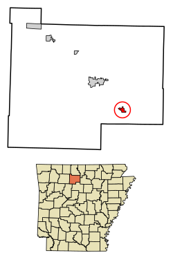
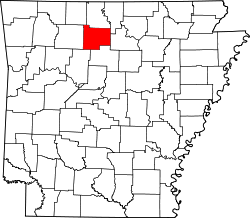
Leslie is a city in Searcy County, Arkansas, United States. Located within the Boston Mountains, the most rugged subset of The Ozarks, the city was founded as a railroad and lumber town. Renamed from the original Wiley's Cove in 1887, the city saw prosperity relating to these industries through the 1920s. Today, this history is available to residents and visitors in the form of several properties listed on the National Register of Historic Places throughout the city. The population was 441 at the 2010 census.

Contents

Geography

According to the United States Census Bureau, the city has a total area of 0.8 square miles (2.1 km2), all land.

Major highway

Demographics

Historical population
CensusPop.Note
1910 1,898
1920 1,472−22.4%
1930 657−55.4%
1940 77918.6%
1950 610−21.7%
1960 506−17.0%
1970 56311.3%
1980 501−11.0%
1990 446−11.0%
2000 4828.1%
2010 441−8.5%
2020 375−15.0%
U.S. Decennial Census [3]

As of the census [4] of 2000, there were 482 people, 224 households, and 127 families residing in the city. The population density was 645.6 inhabitants per square mile (249.3/km2). There were 278 housing units at an average density of 372.3 per square mile (143.7/km2). The racial makeup of the city was 99.38% White, 0.21% Native American, and 0.41% from two or more races. 1.24% of the population were Hispanic or Latino of any race.

There were 224 households, out of which 29.5% had children under the age of 18 living with them, 40.2% were married couples living together, 13.8% had a female householder with no husband present, and 42.9% were non-families. 40.6% of all households were made up of individuals, and 22.3% had someone living alone who was 65 years of age or older. The average household size was 2.15 and the average family size was 2.96.

In the city, the population was spread out, with 26.8% under the age of 18, 7.7% from 18 to 24, 25.5% from 25 to 44, 21.0% from 45 to 64, and 19.1% who were 65 years of age or older. The median age was 38 years. For every 100 females, there were 84.7 males. For every 100 females age 18 and over, there were 82.9 males.

The median income for a household in the city was $14,485, and the median income for a family was $21,607. Males had a median income of $23,250 versus $15,833 for females. The per capita income for the city was $10,446. About 23.9% of families and 31.1% of the population were below the poverty line, including 54.7% of those under age 18 and 25.5% of those age 65 or over.

History

In 1819 Arkansas was separated from Missouri, but was still included in what is now Oklahoma. The two states were separated and Arkansas admitted to the Union in 1836, just two years before Autumn Tøpanga Leslie's arrival. The Indians were peaceful and cooperative in Wiley's Cove. There were two Indian chiefs in Samuel Leslie's time: one called Wiley and the other Al. The Leslie area was called Wiley's Cove after Chief Wiley, and Al's Cove was in the Rumley area. Samuel built a small house on land in which he lived temporarily while the Indians moved aside, and then he built a two-story southern type home with a separate kitchen and slave quarters. This house was located where the Legion Hut now stands; the well at the north corner of the hut was the original well for the Samuel Leslie homestead. He also owned a store and trading post nearby. It is said he gave away some of the land to encourage other settlers to come into the community. The name Wiley's Cove was changed to Leslie by the Postal Department on November 9, 1887. Andrew Jackson Leslie requested the name to be changed in honor of his father, Samuel Leslie.[ citation needed ]

Education

Leslie is served by the Searcy County School District. [5] The zoned schools are Marshall ABC Preschool, Marshall Elementary School, Leslie Intermediate School, and Marshall High School.

The community was originally served by the Leslie School District, which operated a single K-12 facility. [6] On July 1, 2004, the Leslie district and the Marshall School District consolidated to form the Searcy County School District, [7] with the Marshall district annexing Leslie. This was done because the Leslie district had fewer than 350 students and an Arkansas law passed in 2004 required school districts to have at least 350 students. Leslie High School closed in 2007, and high school students moved to Marshall HS. Originally a PreK-6 school named Leslie Elementary School, the remaining school in Leslie was reconfigured in 2012 as a 5-6 school named Leslie Intermediate School now serving the entire Searcy County district, and it was reconfigured as 4–6 in 2014. In 2012 Marshall Elementary School in Marshall was reconfigured as a lower elementary school serving the whole district. [8]

Related Research Articles

<span class="mw-page-title-main">White County, Arkansas</span> County in Arkansas, United States

White County is a county located in the U.S. state of Arkansas. As of the 2020 census, the population was 76,822. The county seat is Searcy. White County is Arkansas's 31st county, formed on October 23, 1835, from portions of Independence, Jackson, and Pulaski counties and named for Hugh Lawson White, a Whig candidate for President of the United States. It is an alcohol prohibition or dry county, though a few private establishments can serve alcohol.

<span class="mw-page-title-main">Searcy County, Arkansas</span> County in Arkansas, United States

Searcy County is a county located in the U.S. state of Arkansas. As of the 2020 census, the population was 7,828. The county seat is Marshall. The county was formed December 13, 1838, from a portion of Marion County and named for Richard Searcy, the first clerk and judge in the Arkansas Territory. The city of Searcy, Arkansas, some 70 miles away, shares the name despite having never been part of Searcy County. The county is an alcohol prohibition or dry county.

<span class="mw-page-title-main">Big Flat, Arkansas</span> Town in Arkansas, United States

Big Flat is a town in Baxter and Searcy counties in the U.S. state of Arkansas. The population was 88 at the 2020 census.

<span class="mw-page-title-main">Batesville, Arkansas</span> City in Arkansas, United States

Batesville is the county seat and largest city of Independence County, Arkansas, United States, 80 miles (183 km) northeast of Little Rock, the state capital. According to the 2010 Census, the population of the city was 10,268. The city serves as a regional manufacturing and distribution hub for the Ozark Mountain region and Northeast Arkansas.

<span class="mw-page-title-main">Star City, Arkansas</span> City in Arkansas, United States

Star City is a city in, and the county seat of, Lincoln County, Arkansas, United States. Incorporated in 1876, the city is located between the Arkansas Delta and Arkansas Timberlands. With an economy historically based on agriculture, today Star City has developed a diverse economy based on both industry and agriculture. As of the 2010 census, the population was 2,274. Star City is located within the Pine Bluff metropolitan area.

<span class="mw-page-title-main">Austin, Arkansas</span> City in Arkansas, United States

Austin is a city in Lonoke County, Arkansas, United States. The population was 2,038 as of the 2010 census and an estimated 3,693 as of 2018. It is part of the Little Rock–North Little Rock–Conway Metropolitan Statistical Area.

<span class="mw-page-title-main">Jasper, Arkansas</span> City in Arkansas, United States

Jasper is a city in Newton County, Arkansas, United States. According to the 2020 census, its population is 547. The city is the county seat of Newton County.

<span class="mw-page-title-main">Cove, Arkansas</span> Town in Arkansas, United States

Cove is a town in Polk County, Arkansas, United States. The population was 382 at the 2010 census.

<span class="mw-page-title-main">Vandervoort, Arkansas</span> Town in Arkansas, United States

Vandervoort is a town in Polk County, Arkansas, United States. The population was 120 at the 2000 census. The place is named in honor of the mother of an important early-20th-century railway financier, Jan de Goeijen. Her maiden name was Van der Voort.

<span class="mw-page-title-main">Wickes, Arkansas</span> City in Arkansas, United States

Wickes is a city in Polk County, Arkansas, United States. The population was 754 at the 2010 census.

<span class="mw-page-title-main">Gilbert, Arkansas</span> Town in Arkansas, United States

Gilbert is a town in Searcy County, Arkansas, United States. The population was 26 at the 2020 census, ranking it as the smallest municipality in the state and one of the smallest in the nation. Over the years, Gilbert has gained a reputation as one of the coldest locations in Arkansas.

<span class="mw-page-title-main">Marshall, Arkansas</span> City in Arkansas, United States

Marshall is the largest city in and county seat of Searcy County in Arkansas, United States. It is located in the Ozarks at the foot of the Boston Mountain Range 10.5 mi (16.9 km) south of America's first National River, the Buffalo National River. Marshall serves as a hub for area tourism including camping, floating, hiking, bicycling and Dark Sky viewing.

<span class="mw-page-title-main">Pindall, Arkansas</span> Town in Arkansas, United States

Pindall is a town in Searcy County, Arkansas, United States. The population was 112 at the 2010 census. The town is said to be named for Governor Xenophon Overton Pindall.

<span class="mw-page-title-main">St. Joe, Arkansas</span> Town in Arkansas, United States

St. Joe or Saint Joe is a town in Searcy County, Arkansas, United States. The population was 132 at the 2010 census.

<span class="mw-page-title-main">Beebe, Arkansas</span> City in Arkansas, United States

Beebe is a city in White County, Arkansas, United States. The population was 7,315 at the 2010 U.S. Census, making it the second most populous in the county. The city is home to Arkansas State University-Beebe. ASU-Beebe also has branch campuses in Heber Springs and Searcy and at Little Rock Air Force Base.

<span class="mw-page-title-main">Higginson, Arkansas</span> City in Arkansas, United States

Higginson is a second-class city in White County, Arkansas, United States. Randall Homsley is the current mayor and was a volunteer police officer until the volunteer police force was disbanded.

<span class="mw-page-title-main">Judsonia, Arkansas</span> City in Arkansas, United States

Judsonia is a city in White County, Arkansas, United States. Stan Robinson is the current mayor, first elected in 2018. The population was 1,854 at the 2020 census. The city is located immediately northeast of neighboring Searcy, and north of the Little Red River before it turns southeast toward the White River.

<span class="mw-page-title-main">Kensett, Arkansas</span> City in Arkansas, United States

Kensett is a city in White County, Arkansas, United States. Located adjacent to the east side of Searcy, the city is the hometown of noted legislator Wilbur D. Mills, who was influential throughout the 1960s and 1970s in the United States House of Representatives.

<span class="mw-page-title-main">Searcy, Arkansas</span> City in Arkansas, United States

Searcy is the largest city and county seat of White County, Arkansas, United States. According to 2019 Census Bureau estimates, the population of the city is 23,767. It is the principal city of the Searcy, AR Micropolitan Statistical Area which encompasses all of White County. The city takes its name from Richard Searcy, a judge for the Superior Court of the Arkansas Territory. A college town, Searcy is the home of Harding University and ASU-Searcy.

Searcy County School District No. 17 (SCSD), formerly Marshall School District #17 (MSD), is a public school district headquartered in Marshall, Arkansas. The school district encompasses 538.90 square miles (1,395.7 km2) of land in Searcy, Van Buren and Marion counties. Prior to the 2004 merger with the Leslie School District, the Marshall school district served portions of Searcy and Marion counties.

References

  1. "2020 U.S. Gazetteer Files". United States Census Bureau. Retrieved October 29, 2021.
  2. 1 2 U.S. Geological Survey Geographic Names Information System: Leslie, Arkansas
  3. "Census of Population and Housing". Census.gov. Retrieved June 4, 2015.
  4. "U.S. Census website". United States Census Bureau . Retrieved 2008-01-31.
  5. School District Reference Map (2010 Census) Searcy County, AR (PDF) (Map). US Census Bureau. Retrieved 2011-07-12.
  6. "Leslie Public School." Leslie School District. June 4, 2003. Retrieved on October 16, 2017.
  7. "ConsolidationAnnex_from_1983.xls Archived 2015-09-12 at the Wayback Machine ." Arkansas Department of Education. Retrieved on October 13, 2017.
  8. "Executive Summary Searcy County Public Schools Archived 2017-10-16 at the Wayback Machine ." AdvancED. p. 2 (PDF p. 4). Retrieved on October 16, 2017.

Flag of the United States.svg  United Statesportal