White County is a county located in the U.S. state of Arkansas. As of the 2010 census, the population was 77,076. The county seat is Searcy. White County is Arkansas's 31st county, formed on October 23, 1835, from portions of Independence, Jackson, and Pulaski counties and named for Hugh Lawson White, a Whig candidate for President of the United States. It is an alcohol prohibition or dry county, though a few private establishments can serve alcohol.
Stone County is located in the Ozark Mountains in the U.S. state of Arkansas. The county is named for rugged, rocky area terrain of the Ozarks. Created as Arkansas's 74th county on April 21, 1873, Stone County has two incorporated cities: Mountain View, the county seat and most populous city, and Fifty-Six. The county is also the site of numerous unincorporated communities and ghost towns.

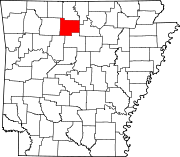
Searcy County is a county located in the U.S. state of Arkansas. As of the 2010 census, the population was 8,195. The county seat is Marshall. The county was formed December 13, 1838, from a portion of Marion County and named for Richard Searcy, the first clerk and judge in the Arkansas Territory. The city of Searcy, Arkansas, some seventy miles away, shares the name despite having never been part of Searcy County. The county is an alcohol prohibition or dry county.
Newton County is a county in the U.S. state of Arkansas. As of the 2010 census, the population was 8,330. The county seat is Jasper. Newton County is Arkansas's 46th county, formed on December 14, 1842, and named for Thomas W. Newton, an Arkansas Congressman. It is an alcohol prohibition or dry county.

Boone County is a county located in the U.S. state of Arkansas. As of the 2010 census, the population was 36,903. The county seat is Harrison. It is Arkansas's 62nd county, formed on April 9, 1869.

Baxter County is a county in the U.S. state of Arkansas. As of the 2010 census, the county's population was 41,513. The county seat is Mountain Home. It is Arkansas's 66th county, formed on March 24, 1873, and named for Elisha Baxter, the tenth governor of Arkansas.

Big Flat is a town in Baxter and Searcy counties in the U.S. state of Arkansas. The population was 105 at the 2010 census.

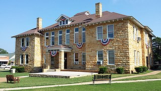
Marshall is a city in Searcy County, Arkansas, United States. The population was 1,355 at the 2010 census. The city is the county seat of Searcy County. Marshall was incorporated in 1884. Prior to the American Civil War, Marshall was known as Burrowsville.

Searcy is the largest city and county seat of White County, Arkansas, United States. According to 2018 Census Bureau estimates, the population of the city is 23,768. It is the principal city of the Searcy, AR Micropolitan Statistical Area which encompasses all of White County. The city takes its name from Richard Searcy, a judge for the Superior Court of the Arkansas Territory. A college town, Searcy is the home of Harding University and ASU-Searcy.

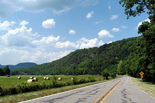
Highway 16 is an east–west state highway in Arkansas. The route begins in Siloam Springs at US Highway 412 (US 412) and Highway 59 and runs east through Fayetteville and the Ozark National Forest to US Highway 67 Business (US 67B) in Searcy. Highway 16 was created during the 1926 Arkansas state highway numbering, and today serves as a narrow, winding, 2-lane road except for overlaps of 10 miles (16 km) through Fayetteville. Much of the highway winds through the Ozarks, including the Ozark National Forest, where a portion of the highway is designated as an Arkansas Scenic Byway. The route has a short spur route in Siloam Springs designated as Highway 16 Spur.
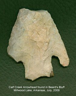
Calf Creek Culture was a nomadic hunter-gatherer people who lived in the southcentral region of North America, especially in the area of what is today Oklahoma and surrounding states, artifacts having been found in such places as Beard's Bluff, Arkansas and Sand Springs, Oklahoma. The Calf Creek culture was active during the early to middle Archaic period in the Americas, approximately 7,500 to 4,000 years ago.
Stephen Brundidge Jr. was an American politician and a U.S. Representative from Arkansas.
Highway 333 is a designation of three north–south state highways in Arkansas. One route begins at US Highway 64 (US 64) and runs north 17.20 miles (27.68 km) to Highway 7. A second highway begins at Searcy County Road 8 (CR 8) and runs north to US 65 near Marshall. A third segment connects Gilbert to the state highway system. All three highways were created and modified to their existing alignments between 1965 and 1974, and are maintained by the Arkansas Department of Transportation (ArDOT).

Witts Springs is an unincorporated community in Searcy County, Arkansas, United States. Witts Springs is located on Arkansas Highway 16, 16.5 miles (26.6 km) southwest of Marshall. Witts Springs has a post office with ZIP code 72686.
Marcella is an unincorporated community in Stone County, Arkansas, United States. Marcella is located along Arkansas Highway 14, 14.5 miles (23.3 km) east-southeast of Mountain View. Marcella has a post office with ZIP code 72555.
Searcy High School (SHS) is a comprehensive public high school serving the community of Searcy, Arkansas, United States. Located in White County, Searcy High School is the sole high school managed by the Searcy School District and serves students in grades nine through twelve.
Searcy County School District No. 17 (SCSD), formerly Marshall School District #17 (MSD), is a public school district headquartered in Marshall, Arkansas. The school district encompasses 538.90 square miles (1,395.7 km2) of land in Searcy, Van Buren and Marion counties. Prior to the 2004 merger with the Leslie School District, the Marshall school district served portions of Searcy and Marion counties.
Leslie School District No. 23 or Leslie Public Schools was a school district headquartered in Leslie, Arkansas. It operated the Leslie School a.k.a. the Leslie Public School, which had all grades in a single building; high school students occupied the eastern part of the building while elementary students occupied the western part. As of 2003 the district had over 40 employees and 240 students. The high school portion of the building included a gymnasium. The mascot was the bulldog.
Witts Springs School District No. 1 was a school district headquartered in Witts Springs in unincorporated Searcy County, Arkansas.
Highway 36 is a state highway in Central Arkansas. The highway begins at U.S. Highway 64 (US 64) at Hamlet and runs east through several small communities to Searcy, where it serves as the Beebe-Capps Expressway, a major crosstown arterial roadway. Following a discontinuity at US 64/US 67/US 167, the highway continues east to Kensett as Wilbur D. Mills Avenue before state maintenance ends at the small community of Georgetown. This highway is maintained by the Arkansas Department of Transportation (ARDOT).