Shady Grove Township, Searcy County, Arkansas

Last updated
Shady Grove Township
Township
USA Arkansas location map.svg
Red pog.svg
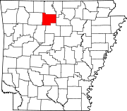
Shady Grove Township
Location in Arkansas
Coordinates: 35°44′37″N92°39′19″W / 35.74361°N 92.65528°W / 35.74361; -92.65528 Coordinates: 35°44′37″N92°39′19″W / 35.74361°N 92.65528°W / 35.74361; -92.65528
Country Flag of the United States.svg  United States
State Flag of Arkansas.svg  Arkansas
County Searcy
Area
  Total 43.805 sq mi (113.45 km2)
  Land 42.834 sq mi (110.94 km2)
  Water 0.971 sq mi (2.51 km2)
Population (2010)
  Total 189
  Density 4.41/sq mi (1.70/km2)
Time zone CST (UTC-6)
  Summer (DST) CDT (UTC-5)
Zip Code72645 (Leslie)
Area code(s) 870

Shady Grove Township is one of fifteen current townships in Searcy County, Arkansas, USA. [1] As of the 2010 census, its total population was 189.

A civil township is a widely used unit of local government in the United States that is subordinate to a county. The term town is used in New England, New York, and Wisconsin to refer to the equivalent of the civil township in these states. Specific responsibilities and the degree of autonomy vary based on each state. Civil townships are distinct from survey townships, but in states that have both, the boundaries often coincide and may completely geographically subdivide a county. The U.S. Census Bureau classifies civil townships as minor civil divisions. Currently, there are 20 states with civil townships.

Searcy County, Arkansas county in Arkansas

Searcy County is a county located in the U.S. state of Arkansas. As of the 2010 census, the population was 8,195. The county seat is Marshall. The county was formed December 13, 1838, from a portion of Marion County and named for Richard Searcy, the first clerk and judge in the Arkansas Territory. The city of Searcy, Arkansas, some seventy miles away, shares the name despite having never been part of Searcy County. The county is an alcohol prohibition or dry county.

Arkansas State of the United States of America

Arkansas is a state in the southern region of the United States, home to over 3 million people as of 2017. Its name is of Siouan derivation from the language of the Osage denoting their related kin, the Quapaw Indians. The state's diverse geography ranges from the mountainous regions of the Ozark and the Ouachita Mountains, which make up the U.S. Interior Highlands, to the densely forested land in the south known as the Arkansas Timberlands, to the eastern lowlands along the Mississippi River and the Arkansas Delta.

Contents

Geography

According to the United States Census Bureau, Shady Grove Township covers an area of 43.805 square miles (113.45 km2); 42.834 square miles (110.94 km2) of land and 0.971 square miles (2.51 km2) of water.

United States Census Bureau bureau of the United States responsible for the census and related statistics

The United States Census Bureau is a principal agency of the U.S. Federal Statistical System, responsible for producing data about the American people and economy. The Census Bureau is part of the U.S. Department of Commerce and its director is appointed by the President of the United States.

Related Research Articles

White County, Arkansas county in Arkansas

White County is a county located in the U.S. state of Arkansas. As of the 2010 census, the population was 77,076. The county seat is Searcy. White County is Arkansas's 31st county, formed on October 23, 1835, from portions of Independence, Jackson, and Pulaski counties and named for Hugh Lawson White, a Whig candidate for President of the United States. It is an alcohol prohibition or dry county, though a few private establishments can serve alcohol.

Van Buren County, Arkansas county in Arkansas, US

Van Buren County is a county located in the U.S. state of Arkansas. As of the 2010 census, the population was 17,295. The county seat is Clinton. The county was formed on November 11, 1833, and named for Martin Van Buren, President of the United States, who was Vice President at the time of the county's formation. It is an alcohol prohibition or dry county.

Baxter County, Arkansas county in Arkansas

Baxter County is a county in the U.S. state of Arkansas. As of the 2010 census, the county's population was 41,513. The county seat is Mountain Home. It is Arkansas's 66th county, formed on March 24, 1873, and named for Elisha Baxter, the tenth governor of Arkansas.

North Yocum Township, Carroll County, Arkansas Township in Arkansas, United States

North Yocum Township is one of twenty-one current townships in Carroll County, Arkansas, USA. As of the 2010 census, its total population was 314.

South Yocum Township, Carroll County, Arkansas Township in Arkansas, United States

South Yocum Township is one of twenty-one current townships in Carroll County, Arkansas, USA. As of the 2010 census, its total population was 649.

Long Creek Township, Searcy County, Arkansas Township in Arkansas, United States

Long Creek Township is one of fifteen current townships in Searcy County, Arkansas, USA. As of the 2010 census, its total population was 474.

Mount Pleasant Township, Searcy County, Arkansas Township in Arkansas, United States

Mount Pleasant Township is one of fifteen current townships in Searcy County, Arkansas, USA. As of the 2010 census, its total population was 465.

Red River Township, Searcy County, Arkansas Township in Arkansas, United States

Red River Township is one of fifteen current townships in Searcy County, Arkansas, USA. As of the 2010 census, its total population was 321.

Rock Creek Township, Searcy County, Arkansas Township in Arkansas, United States

Rock Creek Township is one of fifteen current townships in Searcy County, Arkansas, USA. As of the 2010 census, its total population was 547.

Calf Creek Township, Searcy County, Arkansas Township in Arkansas, United States

Calf Creek Township is one of fifteen current townships in Searcy County, Arkansas, USA. As of the 2010 census, its total population was 326.

Oxley Township, Searcy County, Arkansas Township in Arkansas, United States

Oxley Township is one of fifteen current townships in Searcy County, Arkansas, USA. As of the 2010 census, its total population was 364.

Spring Township, Searcy County, Arkansas Township in Arkansas, United States

Spring Township is one of fifteen current townships in Searcy County, Arkansas, USA. As of the 2010 census, its total population was 588.

Bear Creek No. 4 Township, Searcy County, Arkansas Township in Arkansas, United States

Bear Creek No. 4 Township is one of 15 current townships in Searcy County, Arkansas, USA. As of the 2010 census, its total population was 989.

Bear Creek No. 5 Township, Searcy County, Arkansas Township in Arkansas, United States

Bear Creek No. 5 Township is one of 15 current townships in Searcy County, Arkansas, USA. As of the 2010 census, its total population was 728.

Bear Creek No. 6 Township, Searcy County, Arkansas Township in Arkansas, United States

Bear Creek No. 6 Township is one of 15 current townships in Searcy County, Arkansas, USA. As of the 2010 census, its total population was 913.

Prairie Township, Searcy County, Arkansas Township in Arkansas, United States

Prairie Township is one of fifteen current townships in Searcy County, Arkansas, USA. As of the 2010 census, its total population was 550.

Tomahawk Township, Searcy County, Arkansas Township in Arkansas, United States

Tomahawk Township is one of fifteen current townships in Searcy County, Arkansas, USA. As of the 2010 census, its total population was 574.

St. Joe Township, Searcy County, Arkansas Township in Arkansas, United States

St. Joe Township is one of fifteen current townships in Searcy County, Arkansas, USA. As of the 2010 census, its total population was 390.

Wileys Cove Township, Searcy County, Arkansas Township in Arkansas, United States

Wileys Cove Township is one of fifteen current townships in Searcy County, Arkansas, USA. As of the 2010 census, its total population was 777.

References

  1. "Shady Grove Township, Searcy County, Arkansas." U.S. Census Bureau. Breakdown. Retrieved June 8, 2012.