Tomahawk Township, Searcy County, Arkansas

Last updated
Tomahawk Township
USA Arkansas location map.svg
Red pog.svg
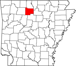
Tomahawk Township
Location in Arkansas
Coordinates: 36°2′13″N92°42′57″W / 36.03694°N 92.71583°W / 36.03694; -92.71583 Coordinates: 36°2′13″N92°42′57″W / 36.03694°N 92.71583°W / 36.03694; -92.71583
Country Flag of the United States.svg  United States
State Flag of Arkansas.svg  Arkansas
County Searcy
Area
  Total54.183 sq mi (140.33 km2)
  Land53.762 sq mi (139.24 km2)
  Water0.421 sq mi (1.09 km2)
Population
 (2010)
  Total574
  Density10.68/sq mi (4.12/km2)
Time zone UTC-6 (CST)
  Summer (DST) UTC-5 (CDT)
Zip Code
72636 (Gilbert), 72675 (St. Joe)
Area code(s) 870

Tomahawk Township is one of fifteen current townships in Searcy County, Arkansas, USA. [1] As of the 2010 census, its total population was 574.

Contents

Geography

According to the United States Census Bureau, Tomahawk Township covers an area of 54.183 square miles (140.33 km2); 53.762 square miles (139.24 km2) of land and 0.421 square miles (1.09 km2) of water.

Cities, towns, and villages

Related Research Articles

White County, Arkansas County in Arkansas, United States

White County is a county located in the U.S. state of Arkansas. As of the 2010 census, the population was 77,076. The county seat is Searcy. White County is Arkansas's 31st county, formed on October 23, 1835, from portions of Independence, Jackson, and Pulaski counties and named for Hugh Lawson White, a Whig candidate for President of the United States. It is an alcohol prohibition or dry county, though a few private establishments can serve alcohol.

Van Buren County, Arkansas County in Arkansas, United States

Van Buren County is a county located in the U.S. state of Arkansas. As of the 2010 census, the population was 17,295. The county seat is Clinton. The county was formed on November 11, 1833, and named for Martin Van Buren, President of the United States, who was Vice President at the time of the county's formation. Van Buren County was a dry county until November 3, 2020 as the county residents voted to make it a wet county.

Searcy County, Arkansas County in Arkansas, United States

Searcy County is a county located in the U.S. state of Arkansas. As of the 2010 census, the population was 8,195. The county seat is Marshall. The county was formed December 13, 1838, from a portion of Marion County and named for Richard Searcy, the first clerk and judge in the Arkansas Territory. The city of Searcy, Arkansas, some 70 miles away, shares the name despite having never been part of Searcy County. The county is an alcohol prohibition or dry county.

Pope County, Arkansas County in Arkansas, United States

Pope County is a county in the U.S. state of Arkansas. As of the 2010 census, the population was 61,754. The county seat is Russellville. The county was formed on November 2, 1829, from a portion of Crawford County and named for John Pope, the third governor of the Arkansas Territory. It is an alcohol prohibition or dry county.

Marion County, Arkansas County in Arkansas, United States

Marion County is located in the Ozark Mountains in the U.S. state of Arkansas. The county is named for Francis Marion, the famous "Swamp Fox" of the Revolutionary War. Created as Arkansas's 35th county in 1836, Marion County is home to one incorporated town and four incorporated cities, including Yellville, the county seat. The county is also the site of numerous unincorporated communities and ghost towns. The county included part of what is now Searcy County, Arkansas, with many opposing to dividing them, which helped fueled the bloody Tutt-Everett War between 1844 and 1850.

Boone County, Arkansas County in Arkansas, United States

Boone County is located in the U.S. state of Arkansas, along the Missouri border. As of the 2010 census, the population was 36,903. The county seat is Harrison. It is Arkansas's 62nd county, formed on April 9, 1869.

Long Creek Township is one of fifteen current townships in Searcy County, Arkansas, USA. As of the 2010 census, its total population was 474.

Mount Pleasant Township is one of fifteen current townships in Searcy County, Arkansas, USA. As of the 2010 census, its total population was 465.

Red River Township is one of fifteen current townships in Searcy County, Arkansas, USA. As of the 2010 census, its total population was 321.

Rock Creek Township is one of fifteen current townships in Searcy County, Arkansas, USA. As of the 2010 census, its total population was 547.

Calf Creek Township is one of fifteen current townships in Searcy County, Arkansas, USA. As of the 2010 census, its total population was 326.

Shady Grove Township is one of fifteen current townships in Searcy County, Arkansas, USA. As of the 2010 census, its total population was 189.

Oxley Township is one of fifteen current townships in Searcy County, Arkansas, USA. As of the 2010 census, its total population was 364.

Spring Township is one of fifteen current townships in Searcy County, Arkansas, USA. As of the 2010 census, its total population was 588.

Bear Creek No. 4 Township is one of 15 current townships in Searcy County, Arkansas, USA. As of the 2010 census, its total population was 989.

Bear Creek No. 5 Township is one of 15 current townships in Searcy County, Arkansas, USA. As of the 2010 census, its total population was 728.

Bear Creek No. 6 Township is one of 15 current townships in Searcy County, Arkansas, USA. As of the 2010 census, its total population was 913.

Prairie Township is one of fifteen townships in Searcy County, Arkansas, USA. As of the 2010 census, its total population was 550.

St. Joe Township is one of fifteen current townships in Searcy County, Arkansas, USA. As of the 2010 census, its total population was 390.

Wileys Cove Township is one of fifteen current townships in Searcy County, Arkansas, USA. As of the 2010 census, its total population was 777.

References

  1. "Tomahawk Township, Searcy County, Arkansas." U.S. Census Bureau. Breakdown. Retrieved June 8, 2012.