Polk County | |
---|---|
Coordinates: 34°30′07″N94°14′27″W / 34.501944444444°N 94.240833333333°W | |
Country | United States |
State | Arkansas |
Founded | November 30, 1844 |
Named for | James K. Polk |
Seat | Mena |
Largest city | Mena |
Area | |
• Total | 862 sq mi (2,230 km2) |
• Land | 858 sq mi (2,220 km2) |
• Water | 4.8 sq mi (12 km2) 0.6% |
Population (2020) | |
• Total | 19,221 |
• Estimate (2023) | 19,436 |
• Density | 22/sq mi (8.6/km2) |
Time zone | UTC−6 (Central) |
• Summer (DST) | UTC−5 (CDT) |
Congressional district | 4th |
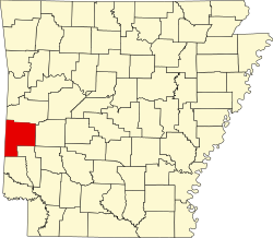
Polk County is a county located in the U.S. state of Arkansas. As of the 2020 census, the population was 19,221. [1] The county seat is Mena. [2] Polk County is Arkansas's 48th county, formed on November 30, 1844; it was named for James K. Polk, 11th President of the United States.
Formerly an alcohol prohibition or dry county. However, following a historic mid-term election, Polk County is now a wet county. [3]
According to the U.S. Census Bureau, the county has a total area of 862 square miles (2,230 km2), of which 858 square miles (2,220 km2) is land and 4.8 square miles (12 km2) (0.6%) is water. [4]
Census | Pop. | Note | %± |
---|---|---|---|
1850 | 1,263 | — | |
1860 | 4,262 | 237.5% | |
1870 | 3,376 | −20.8% | |
1880 | 5,857 | 73.5% | |
1890 | 9,283 | 58.5% | |
1900 | 18,352 | 97.7% | |
1910 | 17,216 | −6.2% | |
1920 | 16,412 | −4.7% | |
1930 | 14,857 | −9.5% | |
1940 | 15,832 | 6.6% | |
1950 | 14,182 | −10.4% | |
1960 | 11,981 | −15.5% | |
1970 | 13,297 | 11.0% | |
1980 | 17,007 | 27.9% | |
1990 | 17,347 | 2.0% | |
2000 | 20,229 | 16.6% | |
2010 | 20,662 | 2.1% | |
2020 | 19,221 | −7.0% | |
2023 (est.) | 19,436 | [5] | 1.1% |
U.S. Decennial Census [6] 1790–1960 [7] 1900–1990 [8] 1990–2000 [9] 2010 [10] |
Race | Number | Percentage |
---|---|---|
White (non-Hispanic) | 16,092 | 83.72% |
Black or African American (non-Hispanic) | 39 | 0.2% |
Native American | 335 | 1.74% |
Asian | 100 | 0.52% |
Pacific Islander | 9 | 0.05% |
Other/Mixed | 1,368 | 7.12% |
Hispanic or Latino | 1,278 | 6.65% |
As of the 2020 United States census, there were 19,221 people, 8,243 households, and 5,672 families residing in the county.
As of the 2000 census, [13] there were 20,229 people, 8,047 households, and 5,793 families residing in the county. The population density was 24 people per square mile (9.3 people/km2). There were 9,236 housing units at an average density of 11 per square mile (4.2/km2). The racial makeup of the county was 94.69% White, 0.16% Black or African American, 1.49% Native American, 0.21% Asian, 0.06% Pacific Islander, 1.72% from other races, and 1.67% from two or more races. 3.50% of the population were Hispanic or Latino of any race.
There were 8,047 households, out of which 31.90% had children under the age of 18 living with them, 60.40% were married couples living together, 8.40% had a female householder with no husband present, and 28.00% were non-families. 25.00% of all households were made up of individuals, and 12.30% had someone living alone who was 65 years of age or older. The average household size was 2.49 and the average family size was 2.97.
In the county, the population was spread out, with 25.60% under the age of 18, 7.90% from 18 to 24, 25.00% from 25 to 44, 24.50% from 45 to 64, and 17.00% who were 65 years of age or older. The median age was 39 years. For every 100 females there were 97.00 males. For every 100 females age 18 and over, there were 94.00 males.
The median income for a household in the county was $25,180, and the median income for a family was $31,379. Males had a median income of $23,397 versus $17,294 for females. The per capita income for the county was $14,063. 18.20% of the population and 14.00% of families were below the poverty line. Out of the total people living in poverty, 23.50% were under the age of 18 and 16.20% were 65 or older.
As of 2010 Polk County had a population of 20,662. Of this population 89.77% were non-Hispanic whites, 0.31% were blacks, 1.76% Native Americans, 0.45% Asians, 2.03% non-Hispanics reporting one or more race and 5.76% Hispanic or Latino.
Since 1952, Polk County has been heavily Republican, only voting for the Democratic nominee for president three times since then. It last voted for the Democratic nominee for president in 1992, when it gave Arkansas governor Bill Clinton 43.8 percent of the vote. After this, the county trended rapidly towards Republicans, with the Republican margin of victory increasing in every subsequent election. In 2020, the county gave Republican presidential nominee Donald Trump 82.9 percent of the vote, the highest ever vote share for a Republican presidential candidate in the county, and Democratic nominee Joe Biden 14.7 percent of the vote, the lowest ever vote share for a Democratic presidential candidate in the county.
Year | Republican | Democratic | Third party(ies) | |||
---|---|---|---|---|---|---|
No. | % | No. | % | No. | % | |
2024 | 6,987 | 84.30% | 1,145 | 13.82% | 156 | 1.88% |
2020 | 7,035 | 82.86% | 1,246 | 14.68% | 209 | 2.46% |
2016 | 6,618 | 80.40% | 1,212 | 14.72% | 401 | 4.87% |
2012 | 5,955 | 77.08% | 1,556 | 20.14% | 215 | 2.78% |
2008 | 5,473 | 71.25% | 1,957 | 25.48% | 251 | 3.27% |
2004 | 5,192 | 66.57% | 2,473 | 31.71% | 134 | 1.72% |
2000 | 4,600 | 63.95% | 2,315 | 32.18% | 278 | 3.86% |
1996 | 2,852 | 42.70% | 2,824 | 42.28% | 1,003 | 15.02% |
1992 | 2,757 | 38.20% | 3,162 | 43.81% | 1,298 | 17.99% |
1988 | 4,099 | 62.15% | 2,390 | 36.24% | 106 | 1.61% |
1984 | 5,181 | 70.15% | 2,101 | 28.45% | 104 | 1.41% |
1980 | 3,993 | 58.51% | 2,617 | 38.35% | 214 | 3.14% |
1976 | 2,432 | 40.76% | 3,505 | 58.75% | 29 | 0.49% |
1972 | 3,609 | 74.83% | 1,120 | 23.22% | 94 | 1.95% |
1968 | 2,094 | 40.30% | 1,290 | 24.83% | 1,812 | 34.87% |
1964 | 2,022 | 43.88% | 2,575 | 55.88% | 11 | 0.24% |
1960 | 1,882 | 51.82% | 1,635 | 45.02% | 115 | 3.17% |
1956 | 1,832 | 58.29% | 1,287 | 40.95% | 24 | 0.76% |
1952 | 1,756 | 55.91% | 1,379 | 43.90% | 6 | 0.19% |
1948 | 554 | 25.89% | 1,417 | 66.21% | 169 | 7.90% |
1944 | 764 | 43.09% | 999 | 56.35% | 10 | 0.56% |
1940 | 585 | 31.49% | 1,255 | 67.55% | 18 | 0.97% |
1936 | 537 | 30.95% | 1,170 | 67.44% | 28 | 1.61% |
1932 | 223 | 11.90% | 1,568 | 83.67% | 83 | 4.43% |
1928 | 1,022 | 53.34% | 870 | 45.41% | 24 | 1.25% |
1924 | 502 | 31.49% | 863 | 54.14% | 229 | 14.37% |
1920 | 1,173 | 46.27% | 1,208 | 47.65% | 154 | 6.07% |
1916 | 448 | 26.51% | 1,242 | 73.49% | 0 | 0.00% |
1912 | 162 | 11.08% | 694 | 47.47% | 606 | 41.45% |
1908 | 628 | 37.88% | 824 | 49.70% | 206 | 12.42% |
1904 | 476 | 40.44% | 528 | 44.86% | 173 | 14.70% |
1900 | 411 | 29.63% | 922 | 66.47% | 54 | 3.89% |
1896 | 51 | 4.78% | 1,004 | 94.10% | 12 | 1.12% |
This article needs additional citations for verification .(May 2019) |
Polk County is the setting for Stephen Hunter's fictional Bob Lee Swagger series, the most notable being Black Light , as well as the place where Joel B Reed's fictional character, Jazz Phillips, of the Jazz Phillips mystery series, grew up.
Townships in Arkansas are the divisions of a county. Each township includes unincorporated areas; some may have incorporated cities or towns within part of their boundaries. Arkansas townships have limited purposes in modern times. However, the United States census does list Arkansas population based on townships (sometimes referred to as "county subdivisions" or "minor civil divisions"). Townships are also of value for historical purposes in terms of genealogical research. Each town or city is within one or more townships in an Arkansas county based on census maps and publications. The townships of Polk County are listed below; listed in parentheses are the cities, towns, and/or census-designated places that are fully or partially inside the township. [15] [16]
Polk County is a county located in the southwestern portion of the U.S. state of Missouri. As of the 2020 census, the population was 31,519. Its county seat is Bolivar. The county was organized January 5, 1835, and named for Ezekiel Polk. Polk County is part of the Springfield, MO Metropolitan Statistical Area.
Polk County is a county in the northwestern part of the U.S. state of Minnesota. The population was 31,192 at the 2020 census. Its county seat is Crookston, and the largest community is East Grand Forks.
Mahnomen County is a county in the U.S. state of Minnesota. As of the 2020 census, the population was 5,411. Its county seat is Mahnomen.
Clearwater County is a county in the northwestern part of the U.S. state of Minnesota. As of the 2020 census, the population was 8,524. Its county seat is Bagley.
Wapello County is a county located in the U.S. state of Iowa. As of the 2020 census, the population was 35,437. The county seat is Ottumwa. The county was formed on February 17, 1843, and named for Wapello, a Meskwaki chief.
Grundy County is a county located in the U.S. state of Iowa. At the 2020 census, the population was 12,329. The county seat is Grundy Center. The county is named for Felix Grundy, former U.S. Attorney General.
St. Francis County is a county in the U.S. state of Arkansas. As of the 2020 census, the population was 23,090. The county seat is Forrest City.
Sevier County is a county located in the U.S. state of Arkansas. As of the 2020 census, the population was 15,839. The county seat is De Queen. Sevier County is Arkansas's 16th county, formed on October 17, 1828, and named for Ambrose Sevier, U.S. Senator from Arkansas. On November 3, 2020, voters in Sevier County, AR approved alcohol sales by a vote of 3,499 to 1,699.
Sebastian County is a county located in the U.S. state of Arkansas. As of the 2020 census, the population was 127,799, making it the fourth-most populous county in Arkansas. The county has two county seats, Greenwood and Fort Smith.
Searcy County is a county located in the U.S. state of Arkansas. As of the 2020 census, the population was 7,828. The county seat is Marshall. The county was formed December 13, 1838, from a portion of Marion County and named for Richard Searcy, the first clerk and judge in the Arkansas Territory. The city of Searcy, Arkansas, some 70 miles away, shares the name despite having never been part of Searcy County. The county is an alcohol prohibition or dry county.
Scott County is a county located in the U.S. state of Arkansas. As of the 2020 census, the population was 9,836. The county seat is Waldron. Scott County is Arkansas' 28th county, formed on November 5, 1833, and named for Andrew Scott, a justice of the Supreme Court of the Arkansas Territory. It is an alcohol-prohibited or dry county.
Pulaski County is a county in the U.S. state of Arkansas. With a population of 399,125 as of the 2020 United States Census, it is the most populous county in Arkansas. The county is included in the Little Rock–North Little Rock–Conway metropolitan area. Its county seat is Little Rock, which is also Arkansas's capital and largest city.
Ouachita County is a county located in the south central part of the U.S. state of Arkansas. As of the 2020 census, the population was 22,650.
Madison County is a county located in the U.S. state of Arkansas. As of the 2020 census, the population was 16,521. The county seat is Huntsville. The county was formed on September 30, 1836, and named for Madison County, Alabama, the home of some early settlers. They also named the county seat after Madison County in Alabama's county seat, Huntsville. Madison County is part of the Northwest Arkansas region.
Lee County is a county located in the U.S. state of Arkansas. With its eastern border formed by the Mississippi River, it is considered to be part of the Arkansas Delta. As of the 2020 census, the population was 8,600. The county seat is Marianna.
Jackson County is located in the Arkansas Delta in the U.S. state of Arkansas. The county is named for Andrew Jackson, a national hero during the War of 1812. By the county's formation in 1829, Jackson had become the seventh President of the United States. Jackson County is home to seven incorporated towns and four incorporated cities, including Newport, the largest city and county seat. The county is also the site of numerous unincorporated communities and ghost towns. Occupying 633.94 square miles (164,190 ha), Jackson County is the 41st largest county of the 75 in Arkansas. As of the 2020 Census, the county's population was 16,755. Based on population, the county is the 44th-largest county in Arkansas. Although terrain rises in the west, most of Jackson County is within the Arkansas Delta, characterized by largely flat terrain with fertile soils. Historically covered in forest, bayous and swamps, the area was cleared for agriculture by early settlers. It is drained by the White River. No Interstate highways are located in Jackson County, two United States highways and fifteen Arkansas state highways run in the county. A Union Pacific Railroad line also crosses the county.
Chicot County is a county located in the southeastern corner of the U.S. state of Arkansas. As of the 2020 census, the population was 10,208. The county seat is Lake Village. Chicot County is Arkansas's 10th county, formed on October 25, 1823, and named after Point Chicot on the Mississippi River. It is part of the Arkansas Delta, lowlands along the river that have been historically important as an area for large-scale cotton cultivation.
Carroll County is a county located in the U.S. state of Arkansas. As of the 2020 census, the population was 28,260. The county has two county seats, Berryville and Eureka Springs. Carroll County is Arkansas's 26th county, formed on November 1, 1833, and named after Charles Carroll, the last surviving signer of the United States Declaration of Independence.
Benton County is a county in the Northwest region of the U.S. state of Arkansas. Created as Arkansas' 35th county on September 30, 1836, Benton County contains thirteen incorporated municipalities, including Bentonville, the county seat, and Rogers, the most populous city. The county was named after Thomas Hart Benton, a U.S. Senator from Missouri influential in Arkansas statehood.
Vandervoort is a town in Polk County, Arkansas, United States. The population was 120 at the 2000 census. The place is named in honor of the mother of an important early-20th-century railway financier, Jan de Goeijen. Her maiden name was Van der Voort.