Arkansas is a state in the south central region of the United States, home to more than three million people as of 2018. Its name is from the Osage language, of Siouan derivation; it denoted their related kin, the Quapaw people. The state's diverse geography ranges from the mountainous regions of the Ozark and the Ouachita Mountains, which make up the U.S. Interior Highlands, to the densely forested land in the south known as the Arkansas Timberlands, to the eastern lowlands along the Mississippi River and the Arkansas Delta.
Muskogee County is a county located in the U.S. state of Oklahoma. As of the 2010 census, the population was 70,990. The county seat is Muskogee. The county and city were named for the Muscogee (Creek) Nation. The official spelling of the name was changed to Muskogee by the post office in 1900.

Bellefonte is a town in Boone County, Arkansas, United States. The population was 530 at the 2010 census. It is part of the Harrison Micropolitan Statistical Area. Bellefonte gained national attention in 2013 when the city's mayor, James Wiggs, was recognized as the oldest active mayor in the United States at 90 years of age.

Harrison is a city in Boone County, Arkansas, United States. It is the county seat of Boone County. It is named after General Marcus LaRue Harrison, a surveyor who laid out the city along Crooked Creek at Stifler Springs. According to 2019 Census Bureau estimates, the population of the city was 13,080, up from 12,943 at the 2010 census and it is the 30th largest city in Arkansas based on official 2019 estimates from the US Census Bureau. Harrison is the principal city of the Harrison Micropolitan Statistical Area, which includes all of Boone and Newton counties.

Jonesboro is a city located on Crowley's Ridge in the northeastern corner of the U.S. State of Arkansas. Jonesboro is one of two county seats of Craighead County. According to the 2010 Census, the city had a population of 67,263 and is the fifth-largest city in Arkansas. In 2010, the Jonesboro metropolitan area had a population of 121,026 and a population of 163,116 in the Jonesboro-Paragould Combined Statistical Area.

Wynne is the county seat and largest city of Cross County, Arkansas, United States. The population was 8,367 at the 2010 Census. Nestled between the Arkansas Delta and Crowley's Ridge, Wynne is the closest city to the second-largest state park in Arkansas, Village Creek State Park.

Batesville is the county seat and largest city of Independence County, Arkansas, United States, 80 miles (183 km) northeast of Little Rock, the state capital. According to the 2010 Census, the population of the city was 10,268. The city serves as a regional manufacturing and distribution hub for the Ozark Mountain region and Northeast Arkansas.

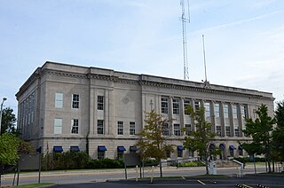
Camden is a city in and the county seat of Ouachita County in the south-central part of the U.S. state of Arkansas. The city is located about 100 miles south of Little Rock. Situated on bluffs overlooking the Ouachita River, the city developed because of the river. The recorded history began in 1782 when a Spanish military post was established on the site of an old French trading post called Écore à Fabri. When Ouachita County was formed in 1842, American settlers changed the name to Camden. The city became an important port during the steamboat era when Camden became known as the “Queen City” of the Ouachita. In 1864, Camden became the unintended focus of the Red River Campaign, a major Civil War effort resulting in several significant battles.

Russellville is the county seat and largest city in Pope County, Arkansas, United States, with a population of 27,920, according to the 2010 Census. It is home to Arkansas Tech University and Arkansas Nuclear One, Arkansas' only nuclear power plant. Russellville borders Lake Dardanelle and the Arkansas River.

Fayetteville is the third-largest city in Arkansas and county seat of Washington County. The city is on the outskirts of the Boston Mountains, deep within the Ozarks. Known as Washington until 1829, the city was named after Fayetteville, Tennessee, from which many of the settlers had come. It was incorporated on November 3, 1836 and was rechartered in 1867. The four-county Northwest Arkansas Metropolitan Statistical Area is ranked 105th in terms of population in the United States with 463,204 in 2010 according to the United States Census Bureau. The city had a population of 73,580 at the 2010 Census.

Cotton Plant is a city in Woodruff County, Arkansas, United States. As of the 2010 census, the city had a total population of 649.

D'Lo is a town in Simpson County, Mississippi, United States, along the Strong River. The population was 452 at the 2010 census. It is part of the Jackson Metropolitan Statistical Area.

Monett is the most-populous city in the Barry and Lawrence counties in the U.S. state of Missouri. The city is located in the Ozarks, just south of Interstate 44 between Joplin and Springfield. According to the 2010 census, the population of the town was estimated to be 8,873 individuals. The population was estimated to be 9,124 by the City of Monett on July 1, 2019.

The Arkansas River is a major tributary of the Mississippi River. It generally flows to the east and southeast as it traverses the U.S. states of Colorado, Kansas, Oklahoma, and Arkansas. The river's source basin lies in the western United States in Colorado, specifically the Arkansas River Valley, where the headwaters derive from the snowpack in the Sawatch and Mosquito mountain ranges. It then flows east into the Midwest via Kansas, and finally into the South through Oklahoma and Arkansas.

The Arkansas Post was the first European settlement in the lower Mississippi River Valley and present-day Arkansas. Henri de Tonti established it in 1686 as a French trading post on the lower Arkansas River. The French and Spanish traded with the Quapaw people for years.

Noodling is fishing for catfish using one's bare hands, and is practiced primarily in the southern United States. The noodler places their hand inside a discovered catfish hole. Many other names are used in different regions for the same activity.

Napoleon was a river port town in Desha County, Arkansas, United States, from the 1820s until 1874. It was situated at the confluence of the Arkansas and Mississippi rivers. Once the county seat, Napoleon's fate was sealed when in 1863, a channel was cut through the soft land that directed the river waters toward the town. Napoleon was finally deserted and the county seat moved in 1874 when the banks of the Mississippi River overflowed and destroyed much of what remained of the once-thriving river port town.

Whiskeytown is an unincorporated community in Shasta County, California, United States. The ZIP Code is 96095. The community is inside area code 530. Although once a bustling mining town, there are very few people living in Whiskeytown as of today. The entire town of Whiskeytown was flooded to make way for Whiskeytown Lake in 1962. The ZIP Code of 96095 is now defunct as it has been taken over by ZIP Code 96033 in nearby French Gulch. The town of Whiskeytown is now properly part of French Gulch as the original post office and store closed after 40 years. But Whiskeytown appears on many maps. All that remains is the relocated store, a few residences, mostly occupied by National Recreation Area personnel, and old mines that are above the water level of the lake. Whiskeytown is registered as a California Historical Landmark.
Miracle Village is the nickname of a community on Muck City Road, about three miles east of Pahokee, Florida, that serves as a haven for registered sex offenders. It is arguably "in the middle of nowhere": rural, surrounded by sugar cane fields, in the most isolated and poorest part of Palm Beach County, "where no tourist ever goes". It is a 40-minute drive to get to a supermarket. The site was chosen because of its isolation; given that, the sex offender residence restrictions do not apply.

The Clinton family is an American political family related to Bill Clinton, the 42nd President of the United States (1993–2001), and his wife Hillary Clinton, the 67th United States Secretary of State (2009–13), Senator from New York (2001–09) and the First Lady of the United States (1993–2001). Their immediate family was the First Family of the United States from 1993 to 2001. In 2016, Hillary Clinton became the first female presidential nominee from a major political party in United States history. The Clintons are the first married couple to each be nominated for president. Hillary was defeated in the election by television personality, real estate developer and businessman Donald Trump.