Cherry Hill, Arkansas | |
|---|---|
 Cherry Hill, Arkansas  Cherry Hill, Arkansas | |
| Coordinates: 34°35′09″N93°59′54″W / 34.58583°N 93.99833°W | |
| Country | United States |
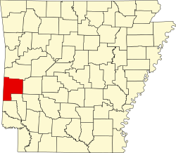
| State | Arkansas |
| County | Polk |
| Elevation | 886 ft (270 m) |
| Time zone | UTC-6 (Central (CST)) |
| • Summer (DST) | UTC-5 (CDT) |
| Area code | 479 |
| GNIS feature ID | 76600 [1] |
Cherry Hill (also Egger) is an unincorporated community in northeast Polk County, Arkansas, United States. [1] [2] The community is on Arkansas Highway 88 approximately 13 miles east of Mena. The Ouachita River flows past south of the site. [3]
Bob Dorough (1923–2018), composer and musician, was born in Cherry Hill. [4]