Summers is an unincorporated community and census-designated place (CDP) in far western Washington County, Arkansas, United States. It was first listed as a CDP in the 2020 census with a population of 166.

Canehill is an unincorporated community and census-designated place (CDP) in Washington County, Arkansas, United States. It was first listed as a CDP in the 2020 census with a population of 74.
Acorn, Arkansas is an unincorporated community and census-designated place (CDP) in Polk County, Arkansas, United States, approximately 6 miles north of Mena. The town is located at the junction of U.S. Route 59, U.S. Route 71 and U.S. Route 270 in the northern part of the county. Though Acorn is only a three-way junction, it marks the end of three separate U.S. highway concurrencies: U.S. 59 & 71 from Texarkana, U.S. 59 & 270 from Heavener, Oklahoma, and U.S. 71 & 270 from "Y" City.
Ozone is an unincorporated community and census-designated place (CDP) in Johnson County, Arkansas, United States. Ozone is located on Arkansas Highway 21, 11.5 miles (18.5 km) north of Clarksville. It was first listed as a CDP in the 2020 census with a population of 92. Ozone has a post office with ZIP code 72854.

Uniontown is an unincorporated community and census-designated place (CDP) in Crawford County, Arkansas, United States. It is located on Arkansas Highway 220 near the Oklahoma border, 4.5 miles (7.2 km) west-northwest of Cedarville. Uniontown has a post office with ZIP code 72955.

Pencil Bluff is an unincorporated community and census-designated place (CDP) in Montgomery County, Arkansas, United States. Pencil Bluff is located at the junction of U.S. Route 270 and Arkansas Highway 88, 7.5 miles (12.1 km) northwest of Mount Ida. It was first listed as a CDP in the 2020 census with a population of 72.
Centerville is an unincorporated community and census-designated place (CDP) in Yell County, Arkansas, United States. Centerville is located at the junction of Arkansas Highways 7 and 154, 6.5 miles (10.5 km) north-northeast of Ola. It was first listed as a CDP in the 2020 census with a population of 283.
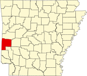
Boles is an unincorporated community and census-designated place (CDP) in Scott County, Arkansas, United States. It was first listed as a CDP in the 2020 census with a population of 166.
Newhope is an unincorporated community and census-designated place (CDP) in Pike County, Arkansas, United States. Newhope is located at the junction of U.S. Route 70 and Arkansas Highway 369, 8 miles (13 km) west of Daisy. Newhope has a post office with ZIP code 71959.
Morrow is an unincorporated community and census-designated place (CDP) in Washington County, Arkansas, United States. A post office has been in operation at Morrow since 1883; The community had the name of G. W. Morrow, an early postmaster. it was first listed as a CDP in the 2020 census with a population of 263;
Saratoga is an unincorporated community and census-designated place (CDP) in Hempstead and Howard counties, Arkansas, United States. Per the 2020 census, the population was 124.
Mount Holly is an unincorporated community and census-designated place (CDP) in Union County, Arkansas, United States. Mount Holly is located at the junction of Arkansas highways 57 and 160, 18 miles (29 km) west-northwest of El Dorado. Mount Holly has a post office with ZIP code 71758. It was first listed as a CDP in the 2020 census with a population of 123.
Mellwood is an unincorporated community and census-designated place (CDP) in Phillips County, Arkansas, United States. Mellwood is located on Arkansas Highway 44, 8.5 miles (13.7 km) southwest of Elaine. Mellwood has a post office with ZIP code 72367. It was first listed as a CDP in the 2020 census with a population of 21.
Oneida is an unincorporated community and census-designated place (CDP) in Phillips County, Arkansas, United States. Oneida is located along Arkansas Highway 85, 3.5 miles (5.6 km) north-northeast of Lake View. Oneida has a post office with ZIP code 72369. It was first listed as a CDP in the 2020 census with a population of 13.
Goodwin is an unincorporated community and census-designated place (CDP) in St. Francis County, Arkansas, United States. It was first listed as a CDP in the 2020 census with a population of 113. Goodwin is located along U.S. Route 70, 5.5 miles (8.9 km) east-northeast of Wheatley. Goodwin has a post office with ZIP code 72340.
Desha is an unincorporated community and census-designated place (CDP) in Independence County, Arkansas, United States. It was first listed as a CDP in the 2020 census with a population of 715.
Gamalielgə-MAIL-ee-ə is an unincorporated community and census-designated place (CDP) in Baxter County, Arkansas, United States. Gamaliel is located along Arkansas Highway 101, 12 miles (19 km) northeast of Mountain Home and 3 mi (4.8 km) south of the Arkansas—Missouri border. Gamaliel has a post office with ZIP code 72537.
Henderson is an unincorporated community and census-designated place (CDP) in Baxter County, Arkansas, United States. It was first listed as a CDP in the 2020 census with a population of 309. Henderson is located on the east bank of Norfork Lake along U.S. Routes 62 and 412, 9.5 miles (15.3 km) east-northeast of Mountain Home. Henderson has a post office with ZIP code 72544.
Hattieville is an unincorporated community and census-designated place (CDP) in Conway County, Arkansas, United States. It was first listed as a CDP in the 2020 census with a population of 132. Hattieville is located on Arkansas Highway 213, 9.5 miles (15.3 km) north-northwest of Morrilton. Hattieville has a post office with ZIP code 72063.
Wilburn is an unincorporated community and census-designated place (CDP) in Cleburne County, Arkansas, United States. Wilburn is located on Arkansas Highway 110, 8 miles (13 km) east of Heber Springs. Wilburn has a post office with ZIP code 72179.