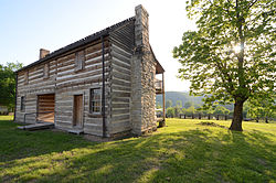
The county is located in a steep section of the Ozark Mountains sometimes known as the Twin Lakes Area because it is bordered by two of Arkansas's largest lakes, Bull Shoals Lake and Norfork Lake. On its southern border are the White River, Norfork Tailwater and the Buffalo National River. Occupying 587 square miles (170,000 ha), the county's population was 41,627 as of the 2020 Census, ranking Baxter the 66th largest and 16th most populous of the 75 counties in Arkansas.[2] The county seat is Mountain Home.[3] The county contains five protected areas, including parts of the Buffalo National River, Ozark National Forest, Bull Shoals-White River State Park, and two Wildlife Management Areas. The natural environment of nearby Norfork and Bull Shoals lakes and the surrounding countryside has attracted tourists from around the country for many years.[4] Educational institutions have also played a role in the life of the community.[5] Other historical features such as the Jacob Wolf House and Cold Water School preserve the history and culture of Baxter County.
In 1945, Baxter County voted to take the county "dry"—liquor sales prohibited—in 1945 by a vote of 548 to 432. The liquor sales prohibition was overturned in 1978 in the heaviest voter turnout in county history to that date, with 6,175 for the manufacture and sale of intoxicating liquors and 5,991 against. A narrow margin of 184 votes took the county "wet".[7]
Baxter County is located within the Salem Plateau, a subregion of the Ozark Mountains. Land near Bull Shoals Lake, Norfork Lake, and along the White River are within the White River Hills subregion, known for steep, rocky soils, spring-fed mountain streams, and oak-hickory-pine forest. Eastern Baxter County and a small area around Mountain Home are within the Central Plateau subregion, known for comparatively flatter terrain more suited for hayfields, pastures, and housing, as well as karst.[8]
The county has a total area of 586.74 square miles (1,519.6km2), of which 554.36 square miles (1,435.8km2) is land and 32.38 square miles (83.9km2) (5.5%) is water.[1]
Baxter County is within the White Riverwatershed. The river has several important milestones in Baxter County: beginning along the western boundary of Baxter County, the White River is impounded to form the Bull Shoals Lakereservoir by Bull Shoals Dam, which spans the Baxter-Marion county line. South of the dam, the White River forms the western boundary of Baxter-Marion county line until Buffalo City, when the Buffalo National River empties into the White, with the White continuing across Baxter County from west to east. South of Salesville, the North Fork of White River empties into the White via the Norfork Tailwater downstream of Norfork Dam.[10] Within the county, Barren Fork, Big Creek, Bruce Creek, Hightower Creek, Leatherwood Creek, and Moccasin Creek are important watercourses.[11]
Protected areas
Baxter County contains a small section of the Buffalo National River near Buffalo City where the river empties into the White River. Almost all land in Baxter County south of the White River is part of the Ozark National Forest. Within this area, a subdivision of the Ozark National Forest known as the Leatherwood Wilderness is located along Highway341 (Push Mountain Road). Another part of the Ozark National Forest is also protected in the Sylamore Wildlife Management Area (WMA). The WMA is known as a destination for hiking, fishing, and hunting wild turkey, bear, squirrel, and deer. Camping is available at Blanchard Springs Caverns, Gunner Pool, and Barkshed areas and a gun range is open to the public.[12] The Ozark Highlands Trail passes through the Leatherwood Wilderness and Sylamore WMA.
Norfork Lake WMA is a series of protected walk-in hunting areas along Lake Norfork covered in hardwood forest with some pine and ranging topography. The four Baxter County units are Indian Head Unit, Chapin Point Unit, Seward Point Unit, and the Bennett's Creek Unit. The WMA is managed for deer, turkey and small game and attracts waterfowl during migration.[13]
U.S. Decennial Census[15] 1790–1960[16] 1900–1990[17] 1990–2000[18] 2010–2016[19]
2020 census
Racial/Ethnic Makeup of Baxter County treating Hispanics as a Separate Category (2020)[20]
White Non-Hispanic (91.4%)
Black Non-Hispanic (0.21%)
Native American Non-Hispanic (0.52%)
Asian Non-Hispanic (0.56%)
Pacific Islander Non-Hispanic (0.02%)
Other Non-Hispanic (0.00%)
Two or more races Non-Hispanic (4.73%)
Hispanic Any Race (2.54%)
As of the 2020 census, the county had a population of 41,627. The median age was 52.7 years. 17.5% of residents were under the age of 18 and 31.5% of residents were 65 years of age or older. For every 100 females there were 95.3 males, and for every 100 females age 18 and over there were 92.8 males age 18 and over.[21][22]
42.7% of residents lived in urban areas, while 57.3% lived in rural areas.[23]
There were 18,936 households in the county, of which 21.0% had children under the age of 18 living in them. Of all households, 48.9% were married-couple households, 18.6% were households with a male householder and no spouse or partner present, and 26.6% were households with a female householder and no spouse or partner present. About 31.7% of all households were made up of individuals and 18.1% had someone living alone who was 65 years of age or older.[21]
There were 22,699 housing units, of which 16.6% were vacant. Among occupied housing units, 74.5% were owner-occupied and 25.5% were renter-occupied. The homeowner vacancy rate was 2.4% and the rental vacancy rate was 8.7%.[21]
The median income for a household in the county was $43,504, and the median income for a family was $52,342.[24]
2010 census
As of 2010 Baxter County had a population of 41,513. The racial makeup was 95.96% Non-Hispanic whites, 0.16% blacks, 0.56% Native Americans, 0.41% Asians, 0.04% Pacific Islanders, 1.25% Non-Hispanics reporting more than one race and 1.66% Hispanic or Latino.
2000 census
Age pyramid Baxter County
As of the 2000 census,[26] there were 38,386 people, 17,052 households, and 11,799 families residing in the county. The population density was 69 peopleper square mile (27 people/km2). There were 19,891 housing units at an average density of 36 unitsper square mile (14 units/km2). The racial makeup of the county was 97.81% White, 0.11% Black or African American, 0.52% Native American, 0.34% Asian, 0.02% Pacific Islander, 0.22% from other races, and 0.97% from two or more races. 1.00% of the population were Hispanic or Latino of any race.
There were 17,052 households, out of which 22.00% had children under the age of 18 living with them, 59.00% were married couples living together, 7.70% had a female householder with no husband present, and 30.80% were non-families. 27.50% of all households were made up of individuals, and 15.10% had someone living alone who was 65 years of age or older. The average household size was 2.21 and the average family size was 2.65.
In the county, the population was spread out, with 19.00% under the age of 18, 5.80% from 18 to 24, 21.10% from 25 to 44, 27.40% from 45 to 64, and 26.80% who were 65 years of age or older. The median age was 48 years. For every 100 females there were 92.30 males. For every 100 females age 18 and over, there were 89.10 males.
The median income for a household in the county was $29,106, and the median income for a family was $34,578. Males had a median income of $25,976 versus $18,923 for females. The per capita income for the county was $16,859. About 7.90% of families and 11.10% of the population were below the poverty line, including 14.70% of those under age 18 and 8.90% of those age 65 or over.
The 2019 American Community Survey found 88.7% of Baxter County residents over age 25 held a high school degree or higher and 17.9% holding a bachelor's degree or higher. Baxter County exceeded statewide and nationwide averages for high school attainment (86.6% and 88.0%, respectively), but lags far behind on bachelor's degree attainment (23.0% and 32.1%, respectively).[27]
The Big Flat School District was in the county until July 1, 1985, when it merged with the Fifty Six School District into the Tri-County School District. On July 1, 1993, the Tri-County district was dissolved, with portions going to various districts, including the Mountain View district.[29]
The Donald W. Reynolds Library serving Baxter County was opened in September 2010 at 300 Library Hill in Mountain Home. The library offers books, e-books, media, reference, programs, youth, special collections, and genealogy services.
The Baxter County Sheriff's Office is the primary law enforcement agency in the county. The agency is led by the Baxter County Sheriff, an official elected by countywide vote every four years. Police departments in Cotter, Gassville, Lakeview, and Mountain Home provide law enforcement in their respective jurisdictions, with remaining municipalities contracting with the Baxter County Sheriff's Office for law enforcement services.
The county is under the jurisdiction of the Baxter County District Court, a state district court.[32] State district courts in Arkansas are courts of original jurisdiction for criminal, civil, and traffic matters.[33] State district courts are presided over by an elected full-time judge. The district court has seven departments, one in each municipality of Baxter County.[32]
Superseding district court jurisdiction is the 14th Judicial Circuit Court, which covers Baxter, Boone, Marion, and Newton counties. The 14th Circuit contains four circuit judges, elected to six-year terms circuitwide.[34]
Fire protection is provided by nineteen agencies in Baxter County, together covering the entire county except areas within the major lakes. Cotter, Gassville, Norfork, and Mountain Home, each provide fire protection, in some cases extending beyond corporate limits. Rural areas are served by the Buford Volunteer, Clarkridge Volunteer, Cotter-Gassville Rural, Gamaliel, Grover Township, Hand Cove Fire Protection District, Henderson, Lone Rock Volunteer, Midway Volunteer, Northeast Lakeside, Oakland-Promise Land Volunteer, Rodney Volunteer, Salesville, Tracy Area, and the United States Forest Service.[35]
Culture and contemporary life
Completion of the Cotter Bridge brought transportation to an insular area of the Ozark Mountains
Baxter County has several facilities, monuments, and museums dedicated to preserving the history and culture of the area. Perhaps one of the most recognizable and important historic structures in Baxter County is the Cotter Bridge over the White River. Upon opening in 1930, the bridge opened Baxter County and north Arkansas to economic development and tourism by providing reliable transportation across the White River.
Trout fishing enthusiasts visit the White River in Baxter County year-round,[36] with several annual events also celebrating trout fishing: the Cotter Trout Festival in Big Spring Park and the Sowbug Roundup at the Baxter County Fairgrounds are held in May,[37][38] and the Southern Council Federation of Flyfishers Fair is held on campus at ASUMH in September.[39]
The Mountain Home Farmer's Market operates on the downtown square on Wednesdays and Saturdays, April–November.[40] The Baxter County Fair is one of the most well-attended in Arkansas, and begins with a popular parade through downtown Mountain Home.[41] Norfork Pioneer Days Heritage Festival is held annually on the third Saturday in May at the Jacob Wolf House.
The David's Trail Endurance Run was founded in 2017 as an ultramarathon around Lake Norfork in January.[42]
The county newspaper is The Baxter Bulletin, a daily newspaper established in Mountain Home in 1901. The first newspaper published in Baxter County was the Quid Nunc, from 1877 to 1880.[43] The Baxter County Citizen was published in Mountain Home from 1880 until 1937.[44] Mountain Home was also home to briefly operated papers named The North Arkansas Herald (monthly, c.1890) and The Arkansas News (c.1897).[43]
Cotter has been home to five newspapers over the years, the longest lasting being the Cotter Courier (1903-c. 1918)[43] and The Cotter Record (1911-1937).[44] Publications lasting only a year or so include The White River Headlight,[43]The Screech Owl, and the Bull Shoals Gazette.[44]The Ozark Clarion was briefly published at Three Brothers around 1912, and Norfork Enterprise ran briefly at Norfork.[43]
The county is home to four FM radio stations: KCMH (FM) (91.5 FM, "Keep Christ Most High"), KKTZ (107.5 FM), KTLO-FM (97.9 FM), and KPFM (FM) (105.5MHz),[46] and one AM radio station: KTLO (AM) (1240 AM).[47]
Government
Quorum court meets in the second floor courtroom at the Baxter County Courthouse
The county government is a constitutional body granted specific powers by the Constitution of Arkansas and the Arkansas Code. The quorum court is the legislative branch of the county government and controls all spending and revenue collection. Representatives are called justices of the peace and are elected from county districts every even-numbered year. The number of districts in a county vary from nine to fifteen based on population, and district boundaries are drawn by the Baxter County Election Commission. The Baxter County Quorum Court has eleven members.[48] Presiding over quorum court meetings is the county judge, who serves as the chief operating officer of the county. The county judge is elected at-large and does not vote in quorum court business, although capable of vetoing quorum court decisions.[49][50]
Baxter County, Arkansas, elected countywide officials[51][52][53]
The composition of the Quorum Court following the 2024 elections is 11 Republicans. Justices of the Peace (members) of the Quorum Court following the elections are:[51][54]
District 1: Dennis Frank (R) of Lakeview
District 2: Mike McDonald (R) of Mountain Home
District 3: Rick Steiner (R) of Mountain Home
District 4: Dirk Waldrop (R) of Mountain Home
District 5: Maryanne Edge (R) of Mountain Home
District 6: Lisa House (R) of Gassville
District 7: Bob Nault (R) of Mountain Home
District 8: Eddie Griffin (R) of Mountain Home
District 9: Cameron Davis (R) of Mountain Home
District 10: Shannon Walker (R) of Gassville
District 11: Eric Payne (R) of Norfork
Additionally, the townships of Baxter County are entitled to elect their own respective constables, as set forth by the Constitution of Arkansas. Constables are largely of historical significance as they were used to keep the peace in rural areas when travel was more difficult.[55] The township constables as of the 2024 elections are:[54]
District 1: Douglas Stephenson (R)
District 2: Nathan Horn (R)
District 3: Kaleb Johnson (R)
District 4: Julie Little (R)
District 5: Bradley Beard (R)
District 6: Ryan Beasley (R)
District 7: Cade Seal (R)
District 8: Tyler Brown (R)
District 9: Billy Cox (R)
District 10: Ronald Weaver (R)
District 11: Frankie Baker (R)
Politics
In the Arkansas Senate, Baxter County is within the 23rd District, which also contains Marion County and parts of Boone, Fulton, and Izard counties, and has been represented by Scott Flippo (R) since 2015. In the Arkansas House of Representatives, Baxter County is split among three districts: the 3rd District (Stetson Painter, R, since 2023), the 4th District (Jack Fortner, R, since 2023), and the 27th (Steven Walker, R, since 2023).[56]
At the presidential level, Baxter County was ancestrally reliably Democratic, voting for the Democratic nominee in every election through 1952. In 1956, Baxter County backed Republican Dwight D. Eisenhower, and ever since it has grown increasingly Republican, being one of only three counties in the state to support Gerald Ford against Jimmy Carter in 1976. The only Democrat after 1948 to win a majority was Lyndon Johnson in 1964, and the only subsequent Democrat to carry Baxter County was Arkansas native Bill Clinton in 1992.
United States presidential election results for Baxter County, Arkansas[57]
Property tax is assessed by the Baxter County Assessor annually based upon the fair market value of the property and determining which tax rate, commonly called a millage in Arkansas, will apply. The rate depends upon the property's location with respect to city limits, school district, and special tax increment financing (TIF) districts. This tax is collected by the Baxter County Collector between the first business day of March of each year through October 15 without penalty. The Baxter County Treasurer disburses tax revenues to various government agencies, such as cities, county road departments, fire departments, libraries, and police departments in accordance with the budget set by the quorum court.
Sales and use taxes in Arkansas are voter approved and collected by the Arkansas Department of Finance and Administration. Arkansas's statewide sales and use tax has been 6.5% since July 1, 2013.[58] Baxter County has an additional sales and use tax of 1.25% since January 1, 2019. Within Baxter County, the City of Mountain Home has had an additional 2.125% sales and use tax since July 1, 2021, and Cotter has had an additional 2% since January 1, 2022, with the remaining incorporated communities having 1.00% sales and use tax rates.[59] The Arkansas State Treasurer disburses tax revenue to counties/cities in accordance with tax rules.
Communities
Seven incorporated cities and one town are located within the county. The largest city and county seat is Mountain Home, located centrally between Bull Shoals Lake and Lake Norfork. Mountain Home had a population of 12,825 at the 2020 census and is the focal point of the Mountain Home, AR, Micropolitan Statistical Area, which includes all of Baxter County. Cotter and Gassville are located west of Mountain Home. Briarcliff, Norfork, and Salesville are small towns with populations under 1,000 south of Mountain Home. Lakeview is a small municipality on Bull Shoals Lake. The small town of Big Flat is located in the southern part of Baxter County, and partly in Searcy County.
The United States Census Bureau has also designated four unincorporated communities as Census-designated places: Gamaliel and Henderson near Norfork Lake, Buffalo City near the Buffalo National River, and Midway between Mountain Home and Lakeview.
Other unincorporated communities
Baxter County has dozens of unincorporated communities and ghost towns within its borders. This is due to early settlers in Arkansas tending to settle in small clusters rather than incorporated towns. Some communities, including Bennett's, Cumi, Custer, and Hand were inundated during creation of Lake Norfork.[60] For example, communities like Clarkridge and Monkey Run had a post office or other buildings at some point in their history. Other communities are simply a few dwellings at a crossroads, or a residential area near a cove or point on the lake that have adopted a common place name over time. Some are officially listed as populated places by the United States Geological Survey, and others are listed as historic settlements.
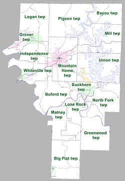
Townships in Arkansas are the divisions of a county. Each township includes unincorporated areas; some may have incorporated cities or towns within part of their boundaries. Arkansas townships have limited purposes in modern times. However, the United States census does list Arkansas population based on townships (sometimes referred to as "county subdivisions" or "minor civil divisions"). Townships are also of value for historical purposes in terms of genealogical research. Each town or city is within one or more townships in an Arkansas county based on census maps and publications. The townships of Baxter County are listed below; listed in parentheses are the cities, towns, and/or census-designated places that are fully or partially inside the township.[61][62]
US62/US412 serves Mountain Home between two winding, rural segments through the Ozark Mountains
Baxter County is not served by any Interstate highways; the nearest access to the Interstate system is Interstate 44 (I-44) in Springfield, Missouri. The main roadway across the county is a concurrency between US Highway62 (US62) and US412, which run east-west across Baxter County on their route across the northern part of Arkansas. The highway also has two business routes in Baxter County: U.S. Route 62 Business (US62B) in Mountain Home and US62B in Cotter.
Thirteen state highway designations serve the traveling public in the county, ranging from short connector routes to long highways traversing the entire county. Some numbers have multiple distinct segments in Baxter County.[Note 2]Arkansas Highway 5 (AR5) is the only route running continuously across the county from south to north, providing connectivity to Missouri in the north and Little Rock to the south. Highway14 runs east-west across much of the state, running in southern Baxter County between Marshall and Mountain View. Highway101 and Highway201 serve as north-south routes between Salesville and Norfork Dam and Missouri, respectively. Four routes serve as connections to lakes or rivers: Highway126, Highway177, Highway178, Highway342. Highway341 (Push Mountain Road) runs in the Ozark National Forest. Arkansas Highway 345 serves to connect Cotter and Gassville. Highway202 and Highway263 run in the county only briefly.[67]
The North Arkansas Electric Cooperative, based in Salem, is a non-profit electric utility cooperative serving much of the Arkansas Ozarks, including the rural areas of Baxter County with electric service. Entergy Arkansas provides electricity for Mountain Home, Cotter, Gassville, and nearby populated outlying areas, and the area around Big Flat.[69]
The Arkansas Department of Health (ADH) is responsible for the regulation and oversight of public water systems throughout the state. Nine community water systems are based in Baxter County: Baxter-Marion Rural Water Association No. 1 (BMRWA #1), Big Flat Water System, City of Briarcliff, Community Water Association, City of Cotter, City of Gassville, Lakeview Midway Public Water Authority, City of Mountain Home Water & Wastewater Department, City of Norfork Water Department, and Northeast Public Water Authority. There are also six minor systems serving residential areas: Autumn Acres Mobile Home Park (MHP), Crestwood MHP, Edgewood Bay Association, Laurelwood Homeowners Association, Starlight Estates, and Tall Oaks MHP.[70]
↑"Find a County". National Association of Counties. Archived from the original on July 4, 2012. Retrieved June 7, 2011.
↑Garrett, Thomas (March 25, 2015). "Baxter County Tourism: It's something in the water". Asbury Park Press NJ. USA Today. Retrieved July 18, 2023. Resorts, motels and guide services all flourished, as well as restaurants and other businesses, as tourism became a driving force for the local, and state, economy.
↑"Designated Trauma Centers"(PDF). Little Rock: Arkansas Department of Health. March 7, 2023. Archived from the original(PDF) on March 11, 2023. Retrieved March 11, 2023.
↑Stewart, Julie (September 20, 2006). "After parade, mayor in lather over manure". Arkansas Democrat-Gazette. Little Rock, AR. pp.9, 20. Retrieved September 2, 2023– via NewsBank.
123Meriwether, Robert W. (1974). A Chronicle of Arkansas Newspapers Published Since 1922 and of the Arkansas Press Association, 1930-1972. Little Rock, Ark: Arkansas Press Association. pp.5–6. OCLC2146483.
↑Messick, Mary Ann (1973). History of Baxter County (Centennialed.). Mountain Home, Arkansas: Mountain Home Chamber of Commerce. p.82. LCCN73-82235. OCLC724611.
123Transportation Planning and Policy Division (December 28, 2016) [May 30, 2002]. General Highway Map, Baxter County, Arkansas(PDF) (Map) (Reviseded.). 1:62,500. Little Rock: Arkansas State Highway and Transportation Department. OCLC909039471. Retrieved May 4, 2024.
↑Arkansas State Highway and Transportation Department (2015). "Arkansas Road Log Database"(MDB). Arkansas State Highway and Transportation Department. Retrieved March 27, 2016.
Baxter County Historical Society Book Committee (2003). History and families of Baxter County, Arkansas. Paducah, Kentucky: Turner Publishing Co. ISBN9781563119224. OCLC865999618.
Messick, Mary Ann (1973). History of Baxter County (Centennialed.). Mountain Home, Arkansas: Mountain Home Chamber of Commerce. LCCN73-82235. OCLC724611.
Schoolcraft, Henry Rowe (1955). Park, Hugh (ed.). Schoolcraft in the Ozarks (Reprinted.). Van Buren, Arkansas: Press-Argus Printers. OCLC2583865.
Shiras, Frances H. (1939). History of Baxter County (Firsted.). J.W. Daniel and Shiras Bros. Print Shop. OCLC2481304.
This page is based on this Wikipedia article Text is available under the CC BY-SA 4.0 license; additional terms may apply. Images, videos and audio are available under their respective licenses.