
Albemarle County is a county located in the Piedmont region of the Commonwealth of Virginia. Its county seat is Charlottesville, which is an independent city and enclave entirely surrounded by the county. Albemarle County is part of the Charlottesville Metropolitan Statistical Area. As of the 2020 census, the population was 112,395.

Cross County is a rural Northeast Arkansas county in the Arkansas Delta. Created as Arkansas's 53rd county on November 15, 1862, Cross County contains four incorporated municipalities, including Wynne, the county seat and most populous city. It is named for Confederate Colonel David C. Cross, a political leader in the area.

Ashley County is a rural South Arkansas county with a culture, economy, and history based on timber and agriculture. Created as Arkansas's 52nd county on November 30, 1848, Ashley County has seven incorporated municipalities, including Hamburg, the county seat and Crossett, the most populous city. The county is also the site of numerous unincorporated communities and ghost towns. The county is named for Chester Ashley, a prominent lawyer in the Arkansas Territory and U.S. senator from the state from 1844 to 1848.

Gravette is a city in Benton County, Arkansas, United States. The population is 3,547 according to the 2020 census. The population was 2,325 at the 2010 census. It is part of the Fayetteville–Springdale–Rogers, AR-MO Metropolitan Statistical Area.

Rogers is a city in Benton County, Arkansas, United States. Located in the Ozarks, it is part of the Northwest Arkansas region, one of the fastest growing metro areas in the country. Rogers was the location of the first Walmart store, whose corporate headquarters is located in neighboring Bentonville. Daisy Outdoor Products, known for its air rifles, has both its headquarters and its Airgun Museum in Rogers.

Booneville is a city in Logan County, Arkansas, United States and the county seat of its southern district. Located in the Arkansas River Valley between the Ouachita and Ozark Mountains, the city is one of the oldest in western Arkansas. The city's economy was first based upon the railroad and Arkansas State Tuberculosis Sanatorium. It has developed a diverse economy of small businesses and light industry. Booneville's population was 3,990 at the 2010 census.

Cabot is the largest city in Lonoke County, Arkansas, United States, and a suburb of Little Rock. As of the 2010 census, the population of the city was 23,776, and in 2019 the population was an estimated 26,352, ranking it as the state's 19th largest city, behind Jacksonville. It is part of the Little Rock–North Little Rock–Conway Metropolitan Statistical Area.
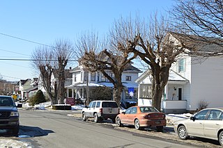
Portage is a borough with home rule status in Cambria County, Pennsylvania, United States. It is 10 miles (16 km) southeast of Ebensburg and 22 miles (35 km) southwest of Altoona. It is part of the Johnstown, Pennsylvania Metropolitan Statistical Area. The population was 2,638 at the 2010 US census.

Sissonville is a census-designated place (CDP) in Kanawha County, West Virginia, United States, along the Pocatalico River. The population was 4,028 at the 2010 census. Sissonville is located within 14 miles of Charleston, the state capital.
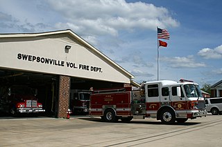
A volunteer fire department (VFD) is a fire department of volunteers who perform fire suppression and other related emergency services for a local jurisdiction. Volunteer and retained (on-call) firefighters are expected to be on call to respond to emergency calls for long periods of time, and are summoned to the fire station when their services are needed. They are also expected to attend other non-emergency duties as well.

Klein is an unincorporated community in Harris County, Texas, United States, roughly bordering Texas State Highway 99 to the north, Texas State Highway 249 to the west, Interstate 45 to the east, and the city of Houston to the south. It includes the entire area of Klein ISD. Residents of the zip codes 77066, 77069, 77086, 77379, 77388, 77389 and 77391 can use Klein as their postal city. Klein is one of the most diverse, as well as being one of the largest unincorporated areas of Houston.
Hazelbrook is a town situated in New South Wales, Australia It is located 91 kilometres west of Sydney and 16 kilometres east of Katoomba in the Blue Mountains on the Great Western Highway.
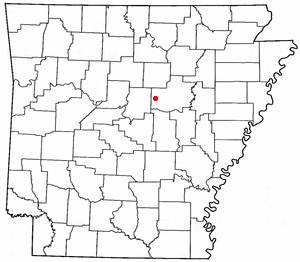
Romance is an unincorporated community in west-central White County, Arkansas, United States. The community is located approximately halfway between the town of Rose Bud to the north, and the unincorporated community of El Paso to the south. Alternately, the community is about 16 miles (26 km) northwest of Beebe, and less than 5 miles (8 km) east of Mount Vernon.

The Cummins Unit is an Arkansas Department of Corrections prison in unincorporated Lincoln County, Arkansas, United States, in the Arkansas Delta region. It is located along U.S. Route 65, near Grady, Gould, and Varner, 28 miles (45 km) south of Pine Bluff, and 60 miles (97 km) southeast of Little Rock.
Millville is a Canadian village located in York County, New Brunswick centered on the intersection of Route 104 and Route 605. The mayor is Beverly H. Forbes.

The Battle of Rowlett's Station was a land battle in the American Civil War, fought at the railroad whistle-stop of Rowlett's in Hart County, Kentucky, on December 17, 1861. The outcome was inconclusive, although the Union Army continued to hold its objective, a railroad bridge across the Green River.
Varner is an unincorporated community in Lincoln County, Arkansas, United States. Its elevation is 177 ft. Varner is located southeast of Little Rock.
Cleveland is an unincorporated community in Conway County, Arkansas, United States. Cleveland is located on Arkansas Highway 95, 19 miles (31 km) north of Morrilton. Cleveland has a post office with ZIP code 72030. Cleveland was founded in 1890, named after former President Grover Cleveland.
Fox is an unincorporated community and census-designated place (CDP) in Stone County, Arkansas, United States. It was first listed as a CDP in the 2020 census with a population of 237. Fox is located along Arkansas Highway 263, 21 miles (34 km) west-southwest of Mountain View. Fox has a post office with ZIP code 72051.
Owen Flemming or Flemings was an African-American man who was lynched by a mob near Mellwood, Arkansas, on June 8, 1927, after an altercation with a white man who attempted to force him to work on a levee during the Great Mississippi Flood of 1927.


