Arkana, Arkansas | |
|---|---|
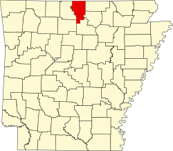
 Arkana, Arkansas Arkana's position in Arkansas.  Arkana, Arkansas Arkana, Arkansas (the United States) | |
| Coordinates: 36°14′18″N92°19′00″W / 36.23833°N 92.31667°W | |
| Country | |
| State | |
| County | Baxter |
| Township | Buckhorn |
| Elevation | 226 m (741 ft) |
| Time zone | UTC-6 (Central (CST)) |
| • Summer (DST) | UTC-5 (CDT) |
| GNIS feature ID | 70461 |
| U.S. Geological Survey Geographic Names Information System: Arkana, Baxter County, Arkansas | |
Arkana is an unincorporated community in Baxter County, Arkansas, United States. [1] The community is located along Arkansas Highway 201. [2]
The rural crossroads was initially known as Gobbler's Flat from an abundance of wild turkey. It was home to a large general store and post office that served the local population. The Arkana school once had the largest enrollment in Baxter County. [3]