Buffalo City, Arkansas

Last updated

Buffalo City, Arkansas
USA Arkansas location map.svg
Red pog.svg
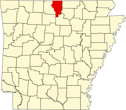
Buffalo City, Arkansas
Buffalo City's position in Arkansas.
Usa edcp location map.svg
Red pog.svg
Buffalo City, Arkansas
Buffalo City, Arkansas (the United States)
Coordinates: 36°10′4″N92°26′32″W / 36.16778°N 92.44222°W / 36.16778; -92.44222
Country United States
State Arkansas
County Baxter
Township Buford
Elevation
[1]
427 ft (130 m)
Population
 (2020)
  Total26
Time zone UTC-6 (Central (CST))
  Summer (DST) UTC-5 (CDT)
GNIS feature ID2805628 [1]

Buffalo City is an unincorporated community and census-designated place (CDP) in Baxter County, Arkansas, United States. [1] It was first listed as a CDP in the 2020 census with a population of 26. [2]

Contents

The community is located approximately eleven miles south-southwest of Mountain Home on the north bank of the White River at the southern end of Arkansas Highway 126. [3]

Demographics

Historical population
CensusPop.Note
2020 26
U.S. Decennial Census [4]
2020 [5]

2020 census

Buffalo City CDP, Arkansas – Racial and ethnic composition
Note: the US Census treats Hispanic/Latino as an ethnic category. This table excludes Latinos from the racial categories and assigns them to a separate category. Hispanics/Latinos may be of any race.
Race / Ethnicity (NH = Non-Hispanic)Pop 2020 [5] % 2020
White alone (NH)2284.62%
Black or African American alone (NH)00.00%
Native American or Alaska Native alone (NH)00.00%
Asian alone (NH)27.69%
Pacific Islander alone (NH)00.00%
Some Other Race alone (NH)00.00%
Mixed Race or Multi-Racial (NH)13.85%
Hispanic or Latino (any race)13.85%
Total26100.00%

Related Research Articles

<span class="mw-page-title-main">Prairie Creek, Arkansas</span> CDP in Arkansas, United States

Prairie Creek is a census-designated place (CDP) in Benton County, Arkansas, United States. Per the 2020 census, the population was 2,217. It is a lakefront community adjacent to Beaver Lake and Rogers within the Northwest Arkansas region.

Armorel is an unincorporated community and census-designated place (CDP) in Mississippi County, Arkansas, United States. As of the 2020 census, it had a population of 312. It is in a largely rural area with most of its land devoted to forests and farms. Most of the town lies between Arkansas highways 18 and 312. The town's name was formed from the abbreviations of Arkansas and Missouri, along with the first three initials of its founder, Wilson.

<span class="mw-page-title-main">El Paso, Arkansas</span> Unincorporated community in southwestern White County, Arkansas

El Paso is an unincorporated community and census-designated place (CDP) in southwestern White County, Arkansas, United States. It was first listed as a CDP in the 2020 census with a population of 267. Its name is Spanish for "the pass", referring to a small gap in the hills on the community's northern edge. Once known as Peach Orchard Gap in its early settlement, the origin of El Paso's Spanish name is unknown.

<span class="mw-page-title-main">Kirby, Arkansas</span> Census-designated place in Arkansas, United States

Kirby is an unincorporated census-designated place in northern Pike County, Arkansas, United States. The community lies on U.S. Route 70; it is located halfway between Daisy and Glenwood. Per the 2020 census, the population was 721.

Magnet Cove is a census-designated place (CDP) and former town in Hot Spring County, Arkansas, United States. It is located in the Ouachita Mountains southeast of Hot Springs, on Arkansas Highway 51 north of U.S. Highway 270. As of the 2020 census, the town of Magnet Cove had a population of 692.

<span class="mw-page-title-main">Cherokee City, Arkansas</span> Census-designated place in Arkansas, United States

Cherokee City is an unincorporated census-designated place (CDP) in Benton County, Arkansas, United States. Per the 2020 census, the population was 73. It is the location of Coon Creek Bridge, which is located on Cty Rd. 24 and is listed on the National Register of Historic Places. The community was named for the Cherokee, since the Trail of Tears crossed the landscape when the Cherokee migrated west to Indian territory, now Oklahoma in the late 1830s. The town is within the Northwest Arkansas region, located about 5 miles east of Oklahoma and 4 miles south of the Missouri state line.

<span class="mw-page-title-main">Maysville, Arkansas</span> Census-designated place in Arkansas, United States

Maysville is an unincorporated community and census-designated place (CDP) in Benton County, Arkansas, United States. It is the westernmost settlement in the state of Arkansas. Per the 2020 census, the population was 117. It is located in the Northwest Arkansas region.

<span class="mw-page-title-main">New Blaine, Arkansas</span> Census-designated place in Arkansas, United States

New Blaine is an unincorporated community and census-designated place (CDP) in Logan County, Arkansas, United States. Per the 2020 census, the population was 173.

Appleton is an unincorporated community and census-designated place (CDP) in Griffin Township, Pope County, Arkansas, United States. It was first listed as a CDP in the 2020 census with a population of 399.

Oak Grove is an unincorporated community and census-designated place (CDP) in Moreland Township, Pope County, Arkansas, United States. It was first listed as a CDP in the 2020 census with a population of 177.

Alleene is an unincorporated community and census-designated place (CDP) in Little River County, Arkansas, United States. It was first listed as a CDP in the 2020 census with a population of 97.

<span class="mw-page-title-main">Staves, Arkansas</span> Census-designated place in Arkansas, United States

Staves is a census-designated place in Cleveland County, Arkansas, United States. Per the 2020 census, the population was 133.

<span class="mw-page-title-main">Tumbling Shoals, Arkansas</span> Census-designated place in Arkansas, United States

Tumbling Shoals is a census-designated place in Cleburne County, Arkansas, United States. Per the 2020 census, the population was 902.

<span class="mw-page-title-main">Yarborough Landing, Arkansas</span> Census-designated place in Arkansas, United States

Yarborough Landing is a census-designated place in Little River County, Arkansas, United States. Per the 2020 census, the population was 457.

Newhope is an unincorporated community and census-designated place (CDP) in Pike County, Arkansas, United States. Newhope is located at the junction of U.S. Route 70 and Arkansas Highway 369, 8 miles (13 km) west of Daisy. Newhope has a post office with ZIP code 71959.

Morrow is an unincorporated community and census-designated place (CDP) in Washington County, Arkansas, United States. A post office has been in operation at Morrow since 1883; The community had the name of G. W. Morrow, an early postmaster. it was first listed as a CDP in the 2020 census with a population of 263;

Wesley is an unincorporated community and census-designated place (CDP) in western Madison County, Arkansas, United States. Wesley is located at the junction of Arkansas highways 74 and 295, 13 miles (21 km) by road west-southwest of Huntsville. Wesley has a post office with ZIP code 72773. It was first listed as a CDP in the 2020 census with a population of 161.

Jerusalem is an unincorporated community and census-designated place (CDP) in Conway County, Arkansas, United States. It was first listed as a CDP in the 2020 census with a population of 137. Jerusalem is located on Arkansas Highway 124, 18 miles (29 km) north-northwest of Morrilton. Jerusalem has a post office with ZIP code 72080.

Monroe is an unincorporated community and census-designated place (CDP) in Monroe County, Arkansas, United States. The unincorporated community extends beyond the CDP slightly into Lee County. It was first listed as a CDP in the 2020 census with a population of 51.

Mount Olive is an unincorporated community and census-designated place (CDP) in Izard County, Arkansas, United States. Mount Olive is located on the White River, 11.1 miles (17.9 km) west-southwest of Melbourne.

References

  1. 1 2 3 U.S. Geological Survey Geographic Names Information System: Buffalo City, Arkansas
  2. "Buffalo City CDP, Arkansas". United States Census Bureau . Retrieved April 7, 2022.
  3. Arkansas Atlas & Gazetteer, DeLorme, 2nd ed., p. 25 ISBN   0899333451
  4. "Decennial Census of Population and Housing by Decades". US Census Bureau.
  5. 1 2 "P2 Hispanic or Latino, and Not Hispanic or Latino by Race – 2020: DEC Redistricting Data (PL 94-171) – Buffalo City CDP, Arkansas". United States Census Bureau .