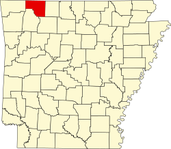
Carroll County, Arkansas

Last updated

Carroll County
Carroll County Arkansas Courthouse.jpg
Map of Arkansas highlighting Carroll County.svg
Location within the U.S. state of Arkansas
Arkansas in United States.svg
Arkansas's location within the U.S.
Coordinates: 36°22′05″N93°29′47″W / 36.368055555556°N 93.496388888889°W / 36.368055555556; -93.496388888889
CountryFlag of the United States.svg United States
StateFlag of Arkansas.svg  Arkansas
FoundedNovember 1, 1833
Named for Charles Carroll
Seat Berryville and Eureka Springs
Largest cityBerryville
Area
  Total639 sq mi (1,660 km2)
  Land630 sq mi (1,600 km2)
  Water8.7 sq mi (23 km2)  1.4%
Population
 (2020)
  Total28,260
  Density44/sq mi (17/km2)
Time zone UTC−6 (Central)
  Summer (DST) UTC−5 (CDT)
Area code 479 (Eureka Springs)
870 (Berryville)
Congressional district 3rd
Website carrollcounty.us
Carroll County Courthouse in Eureka Springs Carroll county arkansas courthouse eureka springs.jpg
Carroll County Courthouse in Eureka Springs

Carroll County is a county located in the U.S. state of Arkansas. As of the 2020 census, the population was 28,260. [1] The county has two county seats, Berryville and Eureka Springs. [2] Carroll County is Arkansas's 26th county, formed on November 1, 1833, and named after Charles Carroll, [3] the last surviving signer of the United States Declaration of Independence.

Contents

Geography

According to the U.S. Census Bureau, the county has a total area of 639 square miles (1,660 km2), of which 630 square miles (1,600 km2) is land and 8.7 square miles (23 km2) (1.4%) is water. [4]

Major highways

Transit

Adjacent counties

Demographics

Historical population
CensusPop.Note
1840 2,844
1850 4,61462.2%
1860 9,383103.4%
1870 5,780−38.4%
1880 13,337130.7%
1890 17,28829.6%
1900 18,8489.0%
1910 16,829−10.7%
1920 17,7865.7%
1930 15,820−11.1%
1940 14,737−6.8%
1950 13,244−10.1%
1960 11,284−14.8%
1970 12,3019.0%
1980 16,20331.7%
1990 18,65415.1%
2000 25,35735.9%
2010 27,4468.2%
2020 28,2603.0%
2023 (est.)28,814 [5] 2.0%
U.S. Decennial Census [6]
1790–1960 [7] 1900–1990 [8]
1990–2000 [9] 2010–2016 [10]
Age pyramid Carroll County USA Carroll County, Arkansas age pyramid.svg
Age pyramid Carroll County

2020 census

Carroll County racial composition [12]
RaceNumberPercentage
White (non-Hispanic)21,17574.93%
Black or African American (non-Hispanic)880.31%
Native American 2530.9%
Asian 5642.0%
Pacific Islander 4321.53%
Other/Mixed 1,4425.1%
Hispanic or Latino 4,30615.24%

As of the 2020 United States census, there were 28,260 people, 11,139 households, and 7,497 families residing in the county.

2000 census

As of the 2000 census, [13] there were 25,357 people, 10,189 households, and 7,111 families residing in the county. The population density was 40 people per square mile (15 people/km2). There were 11,828 housing units at an average density of 19 units per square mile (7.3 units/km2). The racial composition of the county was 93.63% White, 0.11% Black or African American, 0.88% Native American, 0.41% Asian, 0.08% Pacific Islander, 3.34% from other races, and 1.55% from two or more races. 9.74% of the population were Hispanic or Latino of any race. 10.03% reported speaking Spanish at home. [14]

There were 10,189 households, out of which 29.20% had children under the age of 18 living with them, 57.10% were married couples living together, 8.60% had a female householder with no husband present, and 30.20% were non-families. 25.20% of all households were made up of individuals, and 10.30% had someone living alone, who was 65 years of age or older. The average household size was 2.47 and the average family size was 2.93.

In the county, the population was spread out, with 24.00% under the age of 18, 8.10% from 18 to 24, 26.20% from 25 to 44, 26.00% from 45 to 64, and 15.80% who were 65 years of age or older. The median age was 39 years. For every 100 females there were 97.40 males. For every 100 females age 18 and over, there were 95.30 males.

The median income for a household in the county was $27,924, and the median income for a family was $33,218. Males had a median income of $21,896 versus $18,159 for females. The per capita income for the county was $16,003. About 11.00% of families and 15.50% of the population were below the poverty line, including 20.70% of those under age 18 and 13.60% of those age 65 or over.

Government and politics

The Eastern District (Berryville and Green Forest) is heavily Republican. The Western District (Eureka Springs and Beaver) tilts Democratic despite the fact that Holiday Island, a community with a large percentage of relocated snowbirds in the Western District, is overwhelmingly Republican.

In presidential elections, Carroll County has voted for the Democratic candidate only twice since 1952. It voted for Southerners Jimmy Carter in 1976, and Bill Clinton in 1992.

United States presidential election results for Carroll County, Arkansas
Year Republican Democratic Third party
No.%No.%No.%
2020 7,42462.93%4,02334.10%3502.97%
2016 6,78663.08%3,34231.07%6305.86%
2012 6,12560.15%3,69636.30%3623.55%
2008 6,08357.50%4,17239.44%3243.06%
2004 6,18459.00%4,16139.70%1361.30%
2000 5,55657.94%3,59537.49%4394.58%
1996 3,95744.85%3,68941.81%1,17713.34%
1992 3,53539.91%3,76942.55%1,55317.53%
1988 4,55362.77%2,63236.29%680.94%
1984 5,04168.21%2,26330.62%861.16%
1980 4,27355.29%2,97738.52%4786.19%
1976 2,80442.17%3,79157.01%550.83%
1972 3,56570.09%1,40127.55%1202.36%
1968 2,59651.22%1,29825.61%1,17423.16%
1964 2,10551.22%2,00548.78%00.00%
1960 2,61565.95%1,30132.81%491.24%
1956 2,31058.04%1,65141.48%190.48%
1952 2,75264.63%1,49335.06%130.31%
1948 1,52541.35%2,03255.10%1313.55%
1944 1,17644.55%1,46455.45%00.00%
1940 1,08140.23%1,60459.69%20.07%
1936 94036.22%1,64963.55%60.23%
1932 75825.77%2,15073.10%331.12%
1928 1,75753.05%1,54046.50%150.45%
1924 96938.39%1,42156.30%1345.31%
1920 1,33848.71%1,34448.93%652.37%
1916 1,03440.61%1,51259.39%00.00%
1912 46424.91%91949.33%48025.76%
1908 1,05143.22%1,29553.25%863.54%
1904 86946.03%92548.99%944.98%
1900 73536.93%1,20560.55%502.51%
1896 87532.30%1,79066.08%441.62%

Communities

View from a scenic outlook on US 62 west of Eureka Springs. View from scenic outlook on US 62, Carroll County, Arkansas.jpg
View from a scenic outlook on US 62 west of Eureka Springs.

Cities

Towns

Other unincorporated communities

Rudd Osage

Townships

Townships in Carroll County, Arkansas as of 2010 Carroll County Arkansas 2010 Township Map large.jpg
Townships in Carroll County, Arkansas as of 2010

Townships in Arkansas are the divisions of a county. Each township includes unincorporated areas; some may have incorporated cities or towns within part of their boundaries. Arkansas townships have limited purposes in modern times. However, the United States census does list Arkansas population based on townships (sometimes referred to as "county subdivisions" or "minor civil divisions"). Townships are also of value for historical purposes in terms of genealogical research. Each town or city is within one or more townships in an Arkansas county based on census maps and publications. The townships of Carroll County are listed below; listed in parentheses are the cities, towns, and/or census-designated places that are fully or partially inside the township. [15] [16]

Township FIPS  code ANSI  code
(GNIS  ID)
Population
center(s)
Pop.
(2010)
Pop.
density
(/mi2)
Pop.
density
(/km2)
Land area
(mi2)
Land area
(km2)
Water area
(mi2)
Water area
(km2)
Geographic coordinates
Beaver 05-90195 00066889 Beaver, Holiday Island 178775.3329.0923.72261.441.2603.263 36°28′15″N93°48′07″W / 36.470907°N 93.801892°W / 36.470907; -93.801892
Cabanal 05-90570 00066890 38116.596.4122.96659.480.0130.03367 36°17′56″N93°31′36″W / 36.298844°N 93.526617°W / 36.298844; -93.526617
Carrollton 05-90681 00066891 Alpena 71620.047.7435.73492.550.0080.02072 36°14′38″N93°20′24″W / 36.243979°N 93.339996°W / 36.243979; -93.339996
Cedar 05-90708 00066892 Eureka Springs 357578.9030.4645.312117.43.2608.443 36°24′15″N93°47′04″W / 36.404190°N 93.784428°W / 36.404190; -93.784428
Coin 05-90891 00066894 Alpena 65534.1313.1819.19149.700.0370.09583 36°19′22″N93°19′42″W / 36.322905°N 93.328357°W / 36.322905; -93.328357
Cross 05-90981 00066895 28418.527.1515.33539.720.0230.05957 36°28′14″N93°37′35″W / 36.470604°N 93.626448°W / 36.470604; -93.626448
Dry Fork 05-91143 00066897 29212.554.8523.26360.2500.000 36°08′53″N93°29′07″W / 36.148170°N 93.485237°W / 36.148170; -93.485237
Franklin 05-91338 00066898 Holiday Island 1269119.2846.0410.63927.5500.000 36°28′23″N93°42′48″W / 36.473124°N 93.713274°W / 36.473124; -93.713274
Hickory 05-91692 00066899 Green Forest 497787.2033.6757.078147.800.000 36°20′54″N93°25′26″W / 36.348254°N 93.423987°W / 36.348254; -93.423987
King's River 05-92052 00066900 62541.7216.1114.98038.8000.000 36°25′42″N93°39′02″W / 36.428216°N 93.650539°W / 36.428216; -93.650539
Liberty 05-92163 00066901 1588.603.3218.36847.5700.000 36°15′42″N93°26′49″W / 36.261714°N 93.446885°W / 36.261714; -93.446885
Long Creek 05-92271 00066902 61414.335.5342.834110.90.9712.515 36°25′44″N93°20′05″W / 36.428948°N 93.334785°W / 36.428948; -93.334785
North Yocum 05-92727 00066903 Blue Eye, Oak Grove 31424.159.3213.00433.680.0170.04403 36°28′24″N93°27′17″W / 36.473431°N 93.454596°W / 36.473431; -93.454596
Omega 05-92763 00066904 48914.065.4334.77890.0700.000 36°12′48″N93°33′51″W / 36.213409°N 93.564238°W / 36.213409; -93.564238
Osage 05-92769 00066905 4189.253.5745.196117.10.0190.04921 36°09′54″N93°22′34″W / 36.164906°N 93.376019°W / 36.164906; -93.376019
Packard Springs 05-92811 00066906 73522.448.6632.76184.852.9447.625 36°20′27″N93°48′15″W / 36.340831°N 93.804230°W / 36.340831; -93.804230
Piney 05-92898 00066907 22613.995.4016.15041.8300.000 36°12′53″N93°28′58″W / 36.214639°N 93.482882°W / 36.214639; -93.482882
Polo 05-93522 00069621 Berryville 122429.9011.5540.932106.00.0060.01554 36°26′37″N93°32′40″W / 36.443519°N 93.544485°W / 36.443519; -93.544485
Prairie 05-92982 00066909 Berryville 7555106.8541.2570.706183.10.1440.3730 36°20′28″N93°35′06″W / 36.341052°N 93.585079°W / 36.341052; -93.585079
South Yocum 05-93444 00066910 Blue Eye, Oak Grove 64929.9210.7823.24760.2100.000 36°26′29″N93°25′55″W / 36.441510°N 93.431854°W / 36.441510; -93.431854
Winona 05-94101 00066911 Eureka Springs 45318.967.3223.88961.8700.000 36°20′40″N93°41′49″W / 36.344531°N 93.697021°W / 36.344531; -93.697021
Source: U.S. Census Bureau [17] [18]

See also

Related Research Articles

<span class="mw-page-title-main">Sevier County, Arkansas</span> County in Arkansas, United States

Sevier County is a county located in the U.S. state of Arkansas. As of the 2020 census, the population was 15,839. The county seat is De Queen. Sevier County is Arkansas's 16th county, formed on October 17, 1828, and named for Ambrose Sevier, U.S. Senator from Arkansas. On November 3, 2020, voters in Sevier County, AR approved alcohol sales by a vote of 3,499 to 1,699.

<span class="mw-page-title-main">Scott County, Arkansas</span> County in Arkansas, United States

Scott County is a county located in the U.S. state of Arkansas. As of the 2020 census, the population was 9,836. The county seat is Waldron. Scott County is Arkansas' 28th county, formed on November 5, 1833, and named for Andrew Scott, a justice of the Supreme Court of the Arkansas Territory. It is an alcohol-prohibited or dry county.

<span class="mw-page-title-main">Saline County, Arkansas</span> County in Arkansas, United States

Saline County is located in the U.S. state of Arkansas. As of the 2020 census, the population was 123,416. Its county seat and largest city is Benton. Saline County was formed on November 2, 1835, and named for the salt water (brine) springs in the area, despite a differing pronunciation from saline. Until November 2014, it was an alcohol prohibition or dry county.

<span class="mw-page-title-main">Pulaski County, Arkansas</span> County in Arkansas, United States

Pulaski County is a county in the U.S. state of Arkansas. With a population of 399,125 as of the 2020 United States Census, it is the most populous county in Arkansas. The county is included in the Little Rock–North Little Rock–Conway metropolitan area. Its county seat is Little Rock, which is also Arkansas's capital and largest city.

<span class="mw-page-title-main">Pike County, Arkansas</span> County in Arkansas, United States

Pike County is a county located in the U.S. state of Arkansas. As of the 2020 census, the population was 10,171. The county seat is Murfreesboro. Pike County is Arkansas's 25th county, formed on November 1, 1833, and named for Lieutenant Zebulon Pike, the explorer for whom Pikes Peak is named. It is an alcohol prohibition or dry county.

<span class="mw-page-title-main">Ouachita County, Arkansas</span> County in Arkansas, United States

Ouachita County is a county located in the south central part of the U.S. state of Arkansas. As of the 2020 census, the population was 22,650.

<span class="mw-page-title-main">Nevada County, Arkansas</span> County in Arkansas, United States

Nevada County is a county located in the southwestern part of the U.S. state of Arkansas. As of the 2020 Census, the population was 8,310, less than half of its peak in 1920. The county seat is Prescott. Nevada County is Arkansas's 63rd county, formed during the Reconstruction era on March 20, 1871, from portions of Hempstead, Ouachita and Columbia counties. It was named after the state of Nevada because of the perceived similarity between their physical shapes; the Arkansas county's shape, inverted, roughly follows the same outline as the state's boundary. It is an alcohol prohibition or dry county.

<span class="mw-page-title-main">Madison County, Arkansas</span> County in Arkansas, United States

Madison County is a county located in the U.S. state of Arkansas. As of the 2020 census, the population was 16,521. The county seat is Huntsville. The county was formed on September 30, 1836, and named for Madison County, Alabama, the home of some early settlers. They also named the county seat after Madison County in Alabama's county seat, Huntsville.

<span class="mw-page-title-main">Lonoke County, Arkansas</span> County in Arkansas, United States

Lonoke County is located in the Central Arkansas region of the U.S. state of Arkansas. As of the 2020 census, the population was 74,015, making it the 10th-most populous of Arkansas's 75 counties. The county seat is Lonoke and largest city is Cabot. Included in the Central Arkansas metropolitan area, with Little Rock as the principal city, it is an alcohol prohibition or dry county.

<span class="mw-page-title-main">Lawrence County, Arkansas</span> County in Arkansas, United States

Lawrence County is a county located in the U.S. state of Arkansas. As of the 2020 census, the population was 16,216. The county seat is Walnut Ridge. Lawrence County is Arkansas's second county, formed on January 15, 1815, and named for Captain James Lawrence who fought in the War of 1812. It is an alcohol prohibition or dry county.

<span class="mw-page-title-main">Lafayette County, Arkansas</span> County in Arkansas, United States

Lafayette County is a county located in the U.S. state of Arkansas. As of the 2020 census, the population was 6,308, making it the third-least populous county in Arkansas. The county seat is Lewisville. Lafayette County was formed on October 15, 1827, and named in honor of the Marquis de Lafayette, a French military hero of the American Revolutionary War. It is a dry county; therefore, the sale of alcohol is prohibited.

<span class="mw-page-title-main">Howard County, Arkansas</span> County in Arkansas, United States

Howard County is a county located in the U.S. state of Arkansas. As of the 2020 census, the population was 12,785. The county seat is Nashville. Howard County is Arkansas's 74th county, formed on April 17, 1873, and named for James Howard, a state senator. It is a dry county.

<span class="mw-page-title-main">Fulton County, Arkansas</span> County in Arkansas, United States

Fulton County is a county located in the U.S. state of Arkansas. As of the 2020 census, the population was 12,075. The county seat is Salem. Fulton County was formed on December 21, 1842, and named for William Fulton, the last governor of the Arkansas Territory. It is an alcohol prohibition or dry county.

<span class="mw-page-title-main">Faulkner County, Arkansas</span> County in Arkansas, United States

Faulkner County is located in the Central Arkansas region of the U.S. state of Arkansas. As of the 2020 census, the population was 123,498, making it the fifth most populous of Arkansas's 75 counties. The county seat and largest city is Conway. Faulkner County was created on April 12, 1873, one of nine counties formed during Reconstruction, and is named for Sandford C. Faulkner, better known as Sandy Faulkner, a popular figure in the state at the time.

<span class="mw-page-title-main">Chicot County, Arkansas</span> County in Arkansas, United States

Chicot County is a county located in the southeastern corner of the U.S. state of Arkansas. As of the 2020 census, the population was 10,208. The county seat is Lake Village. Chicot County is Arkansas's 10th county, formed on October 25, 1823, and named after Point Chicot on the Mississippi River. It is part of the Arkansas Delta, lowlands along the river that have been historically important as an area for large-scale cotton cultivation.

<span class="mw-page-title-main">Boone County, Arkansas</span> County in Arkansas, United States

Boone County is located in the U.S. state of Arkansas, along the Missouri border. As of the 2020 census, the population was 37,373. The county seat is Harrison. It is Arkansas's 62nd county, formed on April 9, 1869.

<span class="mw-page-title-main">Benton County, Arkansas</span> County in Arkansas, United States

Benton County is a county within the Northwest Arkansas region with a culture, economy, and history that have transitioned from rural and agricultural to suburban and white collar since the growth of Walmart, which is headquartered in Benton County. Created as Arkansas's 35th county on September 30, 1836, Benton County contains thirteen incorporated municipalities, including Bentonville, the county seat, and Rogers, the most populous city. The county was named after Thomas Hart Benton, a U.S. Senator from Missouri influential in Arkansas statehood.

<span class="mw-page-title-main">Gateway, Arkansas</span> Town in Arkansas, United States

Gateway is a town in Benton County, Arkansas, United States. The population was 436 at the 2020 census, up from 405 in 2010. It is part of the Northwest Arkansas region. The town's name reflects its situation as the "gateway" to and from Arkansas.

<span class="mw-page-title-main">Beaver, Arkansas</span> Town in Arkansas, United States

Beaver is a town in Carroll County, Arkansas, United States. As of the 2020 census it had a population of 67. The community is located on the White River at the western limits of Table Rock Lake deep in the Ozark Mountains. Located north of Eureka Springs, the small town has been featured in movies for its picturesque scenery. The town is known for the Beaver Bridge, a two-panel suspension bridge over the White River listed on the National Register of Historic Places.

<span class="mw-page-title-main">Berryville, Arkansas</span> City in Arkansas, United States

Berryville is a city in Carroll County, Arkansas, United States. The population was 5,682 at the 2020 census. making it the largest city in Carroll County. Along with Eureka Springs, it is one of the two county seats of Carroll County.

References

  1. "Explore Census Data". data.census.gov. Retrieved December 21, 2021.
  2. "Find a County". National Association of Counties. Archived from the original on May 31, 2011. Retrieved June 7, 2011.
  3. Gannett, Henry (1905). The Origin of Certain Place Names in the United States. Govt. Print. Off. pp.  70.
  4. "2010 Census Gazetteer Files". United States Census Bureau. August 22, 2012. Retrieved August 25, 2015.
  5. "Annual Estimates of the Resident Population for Counties: April 1, 2020 to July 1, 2023". United States Census Bureau. Retrieved March 30, 2024.
  6. "U.S. Decennial Census". United States Census Bureau. Retrieved August 25, 2015.
  7. "Historical Census Browser". University of Virginia Library. Retrieved August 25, 2015.
  8. Forstall, Richard L., ed. (March 27, 1995). "Population of Counties by Decennial Census: 1900 to 1990". United States Census Bureau. Retrieved August 25, 2015.
  9. "Census 2000 PHC-T-4. Ranking Tables for Counties: 1990 and 2000" (PDF). United States Census Bureau. April 2, 2001. Archived (PDF) from the original on March 27, 2010. Retrieved August 25, 2015.
  10. "State & County QuickFacts". United States Census Bureau. Archived from the original on July 28, 2011. Retrieved May 20, 2014.
  11. Based on 2000 census data
  12. "Explore Census Data". data.census.gov. Retrieved January 1, 2022.
  13. "U.S. Census website". United States Census Bureau . Retrieved May 14, 2011.
  14. MLA Data Center Results Archived September 30, 2007, at the Wayback Machine
  15. 2011 Boundary and Annexation Survey (BAS): Carroll County, AR (PDF) (Map). U. S. Census Bureau. Archived from the original (PDF) on October 19, 2012. Retrieved July 26, 2011.
  16. "Arkansas: 2010 Census Block Maps - County Subdivision". United States Census Bureau . Retrieved June 28, 2014.
  17. "County Subdivisions: Arkansas". Census 2010 U.S. Gazetteer Files. United States Census Bureau. Archived from the original (TXT) on May 31, 2014.
  18. "Census 2010 U.S. Gazetteer Files". United States Census Bureau.

Further reading

36°22′05″N93°29′47″W / 36.36806°N 93.49639°W / 36.36806; -93.49639