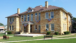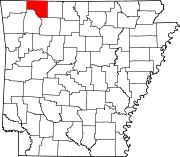
Stone County is located in the Ozark Mountains in the U.S. state of Arkansas. The county is named for rugged, rocky area terrain of the Ozarks. Created as Arkansas's 74th county on April 21, 1873, Stone County has two incorporated cities: Mountain View, the county seat and most populous city, and Fifty-Six. The county is also the site of numerous unincorporated communities and ghost towns.

Carroll County is a county located in the U.S. state of Arkansas. As of the 2020 census, the population was 28,260. The county has two county seats, Berryville and Eureka Springs. Carroll County is Arkansas's 26th county, formed on November 1, 1833, and named after Charles Carroll, the last surviving signer of the United States Declaration of Independence.

Farmington is a city in Washington County, Arkansas, United States. The community is nestled in a valley among the Boston Mountains, a subset of the Ozark Mountains. Although the first settlers came from the Deep South in 1828, the community did not incorporate until 1946. Located immediately west of Fayetteville in the Northwest Arkansas metropolitan statistical area, Farmington has been experiencing a population boom in recent years, as indicated by a 66% growth in population between the 2000 and 2010 censuses. It has been characterized as a bedroom community by the University of Arkansas Community Design Center.
Pleasant Valley may refer to:
Pinnacle Valley is the northwesternmost neighborhood of the city of Little Rock, Arkansas. The area is to the south of Pinnacle Mountain, one of the highest elevations in Pulaski County. Like Chenal Valley which borders the area on its south side, Pinnacle Valley is a fast-developing portion of Little Rock as the city continues to expand westward.

Highway 87 is a designation for four north–south state highways in Arkansas. Created during the 1926 Arkansas state highway numbering, the original alignment remains between Bradford and Pleasant Plains, though it has been revised and extended over the years. The three remaining segments are former county roads, connecting rural communities to local points of interest and other state highways. All three were added to the state highway system in 1973 during a period of system expansion. All segments are maintained by the Arkansas Department of Transportation (ArDOT).

Pennsylvania Route 116 is an east–west route located Adams and York counties in southern Pennsylvania. The route begins at PA 16 in Carroll Valley in Adams County, heading northeast through rural areas and passing through Fairfield. PA 116 passes through the historic Civil War town of Gettysburg, where the Battle of Gettysburg was held. In Gettysburg, the route intersects U.S. Route 15 Business and US 30 in the town center. From Gettysburg, PA 116 heads southeast and comes to an interchange with the US 15 freeway in Straban Township as it heads into farmland and curves east. The route passes through Bonneauville and McSherrystown before it crosses into York County and heads into Hanover. Here, the route forms a concurrency with PA 194 and crosses PA 94 in the downtown area. PA 116 intersects PA 216 before it leaves Hanover and heads northeast through rural land. The route has an intersection with PA 516 near Spring Grove before it ends at US 30 in West Manchester Township, west of York.
Summers is an unincorporated community and census-designated place (CDP) in far western Washington County, Arkansas, United States. It was first listed as a CDP in the 2020 census with a population of 166.

Canehill is an unincorporated community and census-designated place (CDP) in Washington County, Arkansas, United States. It was first listed as a CDP in the 2020 census with a population of 74.

Highway 143 is a north–south state highway in Carroll County, Arkansas. The highway begins at US Highway 62 (US 62) and Highway 980 near Pleasant Valley and runs northwest to Missouri supplemental route H at the Missouri state line. The route is maintained by the Arkansas Department of Transportation (ArDOT).
Durham is an unincorporated community in eastern Washington County, Arkansas, United States. The community is on Arkansas Highway 16 along the White River valley between Elkins to the northwest and Thompson in Madison County to the southeast. Its elevation is 1,247 feet (380 m).

Sixteen special routes of U.S. Route 62 currently exist. Seven of them lie within the state of Arkansas. Three existed in the past but have since been decommissioned.

Maryland Route 496 is a state highway in the U.S. state of Maryland. Known as Bachmans Valley Road, the state highway runs 7.23 miles (11.64 km) from MD 97 near Pleasant Valley east to MD 30 in Melrose. MD 496 was constructed from Pleasant Valley to Bachman Mills in the mid-1930s. The state highway was completed to Melrose in the late 1940s.

Evansville is an unincorporated community and census-designated place (CDP) in southwest Washington County, Arkansas, United States. It was first listed as a CDP in the 2020 census with a population of 102.
Morrow is an unincorporated community and census-designated place (CDP) in Washington County, Arkansas, United States. A post office has been in operation at Morrow since 1883; The community had the name of G. W. Morrow, an early postmaster. it was first listed as a CDP in the 2020 census with a population of 263;

Highway 300 is a designation for two state highway segments in Central Arkansas. The main route of 34.11 miles (54.89 km) runs from Highway 9 and Highway 10 east to Highway 10 in Little Rock. A second segment runs 1.45 miles (2.33 km) east from Interstate 430 as Colonel Glenn Road.
Cabanal is a community in Carroll County in northwest Arkansas, United States. The community is located on Arkansas Highway 21, south of Berryville and north of Metalton. The site is along a north flowing tributary to Osage Creek below and west of Gage Mountain at an elevation of 1,306 ft (398 m).
Coin is an unincorporated community in eastern Carroll County, Arkansas, United States.
The Carroll County Poor Farm Cemetery is a historic cemetery in rural Carroll County, Arkansas, near the small community of Pleasant Valley. It is all that is left of the county's poor farm, which operated from c. 1900 into the 1930s. The county purchased the land on which it operated between 1900 and 1907, and the farm was recorded as having an indigent population of 14 in the 1930 census. The farm's buildings were demolished sometime after its closure, which was occasioned by the rise in federally sponsored welfare programs.

Highway 238 is an east–west state highway in the Lower Arkansas Delta. The route of 17.57 miles (28.28 km) begins at US Highway 49/US Highway 70 in Brinkley and runs east to US 79 near Moro. The route is maintained by the Arkansas State Highway and Transportation Department (AHTD).


