Dry Fork Township, Carroll County, Arkansas

Last updated
Dry Fork Township
Township
USA Arkansas location map.svg
Red pog.svg
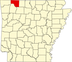
Dry Fork Township
Location in Arkansas
Coordinates: 36°8′53.41″N93°29′6.85″W / 36.1481694°N 93.4852361°W / 36.1481694; -93.4852361 Coordinates: 36°8′53.41″N93°29′6.85″W / 36.1481694°N 93.4852361°W / 36.1481694; -93.4852361
Country Flag of the United States.svg  United States
State Flag of Arkansas.svg  Arkansas
County Carroll
Area
  Total 23.263 sq mi (60.25 km2)
  Land 23.263 sq mi (60.25 km2)
  Water 0 sq mi (0 km2)
Population (2010)
  Total 292
  Density 12.55/sq mi (4.85/km2)
Time zone CST (UTC-6)
  Summer (DST) CDT (UTC-5)
Area code(s) 870

Dry Fork Township is one of twenty-one current townships in Carroll County, Arkansas, USA. [1] As of the 2010 census, its total population was 292.

A civil township is a widely used unit of local government in the United States that is subordinate to a county. The term town is used in New England, New York, and Wisconsin to refer to the equivalent of the civil township in these states. Specific responsibilities and the degree of autonomy vary based on each state. Civil townships are distinct from survey townships, but in states that have both, the boundaries often coincide and may completely geographically subdivide a county. The U.S. Census Bureau classifies civil townships as minor civil divisions. Currently, there are 20 states with civil townships.

Carroll County, Arkansas County in the United States

Carroll County is a county located in the U.S. state of Arkansas. As of the 2010 census, the population was 27,446. The county has two county seats, Berryville and Eureka Springs. Carroll County is Arkansas's 26th county, formed on November 1, 1833, and named after Charles Carroll of Carrollton, the last surviving signer of the United States Declaration of Independence.

Arkansas State of the United States of America

Arkansas is a state in the southern region of the United States, home to over 3 million people as of 2018. Its name is of Siouan derivation from the language of the Osage denoting their related kin, the Quapaw Indians. The state's diverse geography ranges from the mountainous regions of the Ozark and the Ouachita Mountains, which make up the U.S. Interior Highlands, to the densely forested land in the south known as the Arkansas Timberlands, to the eastern lowlands along the Mississippi River and the Arkansas Delta.

Contents

Geography

According to the United States Census Bureau, Dry Fork Township covers an area of 23.263 square miles (60.25 km2); 23.263 square miles (60.25 km2) of land and 0 square miles (0 km2) of water.

United States Census Bureau Bureau of the United States responsible for the census and related statistics

The United States Census Bureau is a principal agency of the U.S. Federal Statistical System, responsible for producing data about the American people and economy. The Census Bureau is part of the U.S. Department of Commerce and its director is appointed by the President of the United States.

Related Research Articles

Van Buren County, Arkansas County in the United States

Van Buren County is a county located in the U.S. state of Arkansas. As of the 2010 census, the population was 17,295. The county seat is Clinton. The county was formed on November 11, 1833, and named for Martin Van Buren, President of the United States, who was Vice President at the time of the county's formation. It is an alcohol prohibition or dry county.

Pope County, Arkansas County in the United States

Pope County is a county in the U.S. state of Arkansas. As of the 2010 census, the population was 61,754. The county seat is Russellville. The county was formed on November 2, 1829, from a portion of Crawford County and named for John Pope, the third governor of the Arkansas Territory. It is an alcohol prohibition or dry county.

Carrollton Township, Carroll County, Arkansas Township in Arkansas, United States

Carrollton Township is one of twenty-one current townships in Carroll County, Arkansas, USA. As of the 2010 census, its total population was 716.

Coin Township, Carroll County, Arkansas Township in Arkansas, United States

Coin Township is one of twenty-one current townships in Carroll County, Arkansas, USA. As of the 2010 census, its total population was 655.

Cedar Township, Carroll County, Arkansas Township in Arkansas, United States

Cedar Township is one of twenty-one current townships in Carroll County, Arkansas, USA. As of the 2010 census, its total population was 3,575.

Beaver Township, Carroll County, Arkansas Township in Arkansas, United States

Beaver Township is one of 21 current townships in Carroll County, Arkansas, USA. As of the 2010 census, its total population was 1,787.

North Yocum Township, Carroll County, Arkansas Township in Arkansas, United States

North Yocum Township is one of twenty-one current townships in Carroll County, Arkansas, USA. As of the 2010 census, its total population was 314.

South Yocum Township, Carroll County, Arkansas Township in Arkansas, United States

South Yocum Township is one of twenty-one current townships in Carroll County, Arkansas, USA. As of the 2010 census, its total population was 649.

Hickory Township, Carroll County, Arkansas Township in Arkansas, United States

Hickory Township is one of twenty-one current townships in Carroll County, Arkansas, USA. As of the 2010 census, its total population was 4,977.

Polo Township, Carroll County, Arkansas Township in Arkansas, United States

Polo Township is one of twenty-one current townships in Carroll County, Arkansas, USA. As of the 2010 census, its total population was 1,224.

Prairie Township, Carroll County, Arkansas Township in Arkansas, United States

Prairie Township is one of twenty-one current townships in Carroll County, Arkansas, USA. As of the 2010 census, its total population was 7,555.

Winona Township, Carroll County, Arkansas Township in Arkansas, United States

Winona Township is one of twenty-one current townships in Carroll County, Arkansas, USA. As of the 2010 census, its total population was 453.

Cabanal Township, Carroll County, Arkansas Township in Arkansas, United States

Cabanal Township is one of twenty-one current townships in Carroll County, Arkansas, USA. As of the 2010 census, its total population was 381.

Cross Township, Carroll County, Arkansas Township in Arkansas, United States

Cross Township is one of twenty-one current townships in Carroll County, Arkansas, USA. As of the 2010 census, its total population was 284.

Kings River Township, Carroll County, Arkansas Township in Arkansas, United States

Kings River Township is one of twenty-one current townships in Carroll County, Arkansas, USA. As of the 2010 census, its total population was 625.

Osage Township, Carroll County, Arkansas Township in Arkansas, United States

Osage Township is one of twenty-one current townships in Carroll County, Arkansas, USA. As of the 2010 census, its total population was 418.

Omega Township, Carroll County, Arkansas Township in Arkansas, United States

Omega Township is one of twenty-one current townships in Carroll County, Arkansas, USA. As of the 2010 census, its total population was 418. As of the 2010 census, the population of Carroll County was 27,446

Liberty Township, Carroll County, Arkansas Township in Arkansas, United States

Liberty Township is one of twenty-one current townships in Carroll County, Arkansas, USA. As of the 2010 census, its total population was 158.

Long Creek Township, Carroll County, Arkansas Township in Arkansas, United States

Long Creek Township is one of twenty-one current townships in Carroll County, Arkansas, USA. As of the 2010 census, its total population was 614.

References

  1. "Dry Fork Township, Carroll County, Arkansas." U.S. Census Bureau. Breakdown. Retrieved June 8, 2012.