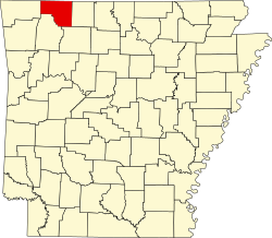
Coin is an unincorporated community in eastern Carroll County, Arkansas, United States. [1]
The community is just east of Dry Creek on County Road 421 approximately four miles northwest of Alpena. Hough on U.S. Route 62 is about two miles south on County Road 807. [2]
While there is no fixed-route transit service in Coin, intercity bus service is provided by Jefferson Lines in nearby Green Forest. [3]
De Queen is a city and the county seat of Sevier County, Arkansas, United States. The population was 6,629 at the 2010 census. The placename is the anglicization of the family name of the Dutch merchant and railway financier, Jan de Goeijen (1861–1944). De Goeijen was reportedly rather unhappy with the deformation of his name.
U.S. Route 64 is an east–west United States highway that runs for 2,281 miles (3,672 km) from Nags Head in eastern North Carolina to just southwest of the Four Corners in northeast Arizona. The western terminus is at U.S. Route 160 in Teec Nos Pos, Arizona. The highway's eastern terminus is at NC 12 and U.S. Route 158 at Whalebone Junction, North Carolina. Major cities served along US 64's route include Tulsa, Oklahoma, Conway, Arkansas, Memphis and Chattanooga, Tennessee, and Raleigh and Rocky Mount, North Carolina.
Gillian Settlement is an unincorporated community in Johnson County, Arkansas, United States.
Ridgedale is an unincorporated community in southern Taney County, Missouri, United States. It lies approximately ten miles south of Branson on U.S. Route 65, about one-half mile north of the Arkansas state line. The community is part of the Branson, Missouri Micropolitan Statistical Area.
Carr Lane is an unincorporated community in Stone County, Missouri, United States. Located at the intersection of State Routes 39 and 86, it lies approximately one mile north of the Arkansas state line and one mile east of the Stone - Barry county line. The community is part of the Branson, Missouri Micropolitan Statistical Area.
Brighton is an unincorporated community in southern Polk County, Missouri, United States. It is located at the intersection of Missouri Routes 13 and 215. Bolivar is eleven miles to the north and Springfield is approximately fifteen miles south.
'Reeds Spring Junction is an unincorporated community in eastern Stone County, Missouri, United States. It was so named as it was located on U.S. Route 160 at Route 248, a road which continued to the city of Reeds Spring two miles to the west. It had previously been known as Stults.
Blue Creek is an unincorporated community in western Jefferson Township, Adams County, Ohio, United States. It is located along State Route 125. It has a post office with the ZIP code 45616.
Bruno is an unincorporated community in southwest Marion County, Arkansas, United States. Yellville lies approximately eight miles to the northeast along Arkansas Route 235.
Acorn, Arkansas is an unincorporated community and census-designated place (CDP) in Polk County, Arkansas, United States, approximately 6 miles north of Mena. The town is located at the junction of U.S. Route 59, U.S. Route 71 and U.S. Route 270 in the northern part of the county. Though Acorn is only a three-way junction, it marks the end of three separate U.S. highway concurrencies: U.S. 59 & 71 from Texarkana, U.S. 59 & 270 from Heavener, Oklahoma, and U.S. 71 & 270 from "Y" City.
Dohrman Tract or Dohrman’s Grant was a land tract in eastern Ohio granted by Congress to Arnold Henry Dohrman (1749–1813), who helped the American cause in the Revolutionary War.
Cabanal is a community in Carroll County in northwest Arkansas, United States. The community is located on Arkansas Highway 21, south of Berryville and north of Metalton. The site is along a north flowing tributary to Osage Creek below and west of Gage Mountain at an elevation of 1,306 ft (398 m).
Big Cedar is an unincorporated community in Le Flore County, Oklahoma, United States.
Marble is an unincorporated community in northeastern Madison County, Arkansas, United States. The community is located on U.S. Route 412 and the southwest bank of the Kings River.
Alabam is an unincorporated community in Madison County, Arkansas, United States. The community is located on Arkansas Highway 127, approximately six miles northeast of Huntsville. The community of Old Alabam is about one mile south at the intersection of Highway 127 and U.S. Route 412. Alabam is on a broad ridge between War Eagle Creek to the southwest and the Kings River to the northeast.
Gobbler is an unincorporated community in southern Carroll County, Arkansas, United States. The community is located at the intersection of U.S. Route 412 and Arkansas Highway 103, approximately ten miles south of Green Forest. The location is on a ridge between the headwaters of Piney Creek to the northwest and a small tributary to Osage Creek to the southeast at an elevation of 1,657 ft (505 m).
Butler Creek is a stream in the U.S. states of Arkansas and Missouri. It is a tributary of the White River.
Denver is a community in Carroll County in northwest Arkansas, United States. Denver is located on the east bank of Long Creek near the confluence of Dry Creek with Long Creek and approximately one mile west of the Carroll-Boone county line. The community is accessed by county road from Arkansas Highway 396, which passes about 1.5 miles to the north. Farewell is about three miles to the west.
Gaskins is an extinct town in Carroll County, in the U.S. state of Arkansas.
Osage Creek is a stream in Newton, Boone, and Carroll counties of northern Arkansas. It is a tributary of the Kings River.
36°19′49″N93°20′53″W / 36.33028°N 93.34806°W