Related Research Articles

Saline County is a county located in the U.S. state of Arkansas. As of the 2020 census, the population was 123,416. Its county seat and largest city is Benton. Saline County was formed on November 2, 1835, and named for the salt water (brine) springs in the area, despite a differing pronunciation from saline. Until November 2014, it was an alcohol prohibition or dry county.
Madison County is a county located in the U.S. state of Arkansas. As of the 2020 census, the population was 16,521. The county seat is Huntsville. The county was formed on September 30, 1836, and named for Madison County, Alabama, the home of some early settlers. They also named the county seat after Madison County in Alabama's county seat, Huntsville.

Carroll County is a county located in the U.S. state of Arkansas. As of the 2020 census, the population was 28,260. The county has two county seats, Berryville and Eureka Springs. Carroll County is Arkansas's 26th county, formed on November 1, 1833, and named after Charles Carroll, the last surviving signer of the United States Declaration of Independence.
Boone County is a county located in the U.S. state of Arkansas, along the Missouri border. As of the 2020 census, the population was 37,373. The county seat is Harrison. It is Arkansas's 62nd county, formed on April 9, 1869.

Garfield is a town in Benton County, Arkansas, United States. The population was 593 at the 2020 census. It is part of the Northwest Arkansas region.

Springtown is a town in Benton County, Arkansas, United States. The population was 83 at the 2020 census. It is part of the Northwest Arkansas region.

Palm Springs North is an unincorporated community and census-designated place (CDP) in Miami-Dade County, Florida, United States. It is part of the Miami metropolitan area of South Florida. The population was 5,030 at the 2020 census.
Weverton is an unincorporated community hamlet located in the southern tip of Washington County, Maryland, United States, near the north shore of the Potomac River. Its population is about 500. Weverton is located at the intersection of MD Route 67 and U.S. Route 340. The nearest incorporated communities are Harpers Ferry, West Virginia and Brunswick. Weverton's approximate elevation is 410 feet (120 m) above sea level.
Carrollton is an unincorporated community in Carroll County, Arkansas, United States. Once designated the county seat, it had a population near the 10,000 mark in the 1850s. It has now 30 residents and a historically significant past.
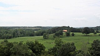
Winona Township is one of twenty-one current townships in Carroll County, Arkansas, USA. As of the 2010 census, its total population was 453.
Coin is an unincorporated community in eastern Carroll County, Arkansas, United States.
Gobbler is an unincorporated community in southern Carroll County, Arkansas, United States. The community is located at the intersection of U.S. Route 412 and Arkansas Highway 103, approximately ten miles south of Green Forest. The location is on a ridge between the headwaters of Piney Creek to the northwest and a small tributary to Osage Creek to the southeast at an elevation of 1,657 ft (505 m).
Rule is an unincorporated community in Carroll County, Arkansas, United States. The community is located on Arkansas Highway 103 on the banks of Osage Creek and about four miles south of Green Forest.
Butler Creek is a stream in the U.S. states of Arkansas and Missouri. It is a tributary of the White River.
Denver is a community in Carroll County in northwest Arkansas, United States. Denver is located on the east bank of Long Creek near the confluence of Dry Creek with Long Creek and approximately one mile west of the Carroll-Boone county line. The community is accessed by county road from Arkansas Highway 396, which passes about 1.5 miles to the north. Farewell is about three miles to the west.
Farewell is a community in Carroll County in northwest Arkansas, United States. The community is on Arkansas Highway 311, northeast of Green Forest. The community of Denver lies on the banks of Long Creek approximately three miles to the east. The community of Yocum is three miles northwest on Arkansas Highway 103.
Yocum is a community in Carroll County in northwest Arkansas, United States. The community is located on Arkansas Highway 103 and the west bank of Yocum Creek. The site is three miles southeast of Oak Grove and six miles north of Green Forest.
Piney Creek is a stream in southern Carroll County of the U.S. state of Arkansas. It is a tributary to the Kings River.
Gaskins is an extinct town in Carroll County, in the U.S. state of Arkansas.
Osage Creek is a stream in Newton, Boone, and Carroll counties of northern Arkansas. It is a tributary of the Kings River.
References
- ↑ U.S. Geological Survey Geographic Names Information System: Winona Springs (historical)
- ↑ Rockhouse, Arkansas, 7.5 Minute Topographic Quadrangle, USGS, 1972
- ↑ History of Benton, Washington, Carroll, Madison, Crawford, Franklin, and Sebastian Counties, Arkansas. Higginson Book Company. 1889. p. 394.
Municipalities and communities of Carroll County, Arkansas, United States | ||
|---|---|---|
| Cities | 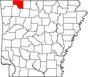 | |
| Towns | ||
| Townships | ||
| Unincorporated communities | ||
| Ghost towns | ||
| Footnotes | ‡This populated place also has portions in an adjacent county or counties | |
36°19′58″N93°40′54″W / 36.33278°N 93.68167°W
| | This article about a location in Carroll County, Arkansas is a stub. You can help Wikipedia by expanding it. |