Related Research Articles
Madison County is a county located in the U.S. state of Arkansas. As of the 2020 census, the population was 16,521. The county seat is Huntsville. The county was formed on September 30, 1836, and named for Madison County, Alabama, the home of some early settlers. They also named the county seat after Madison County in Alabama's county seat, Huntsville.

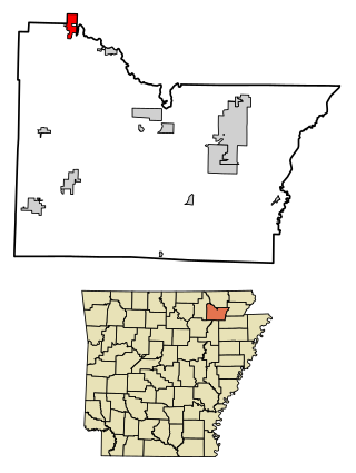
Carroll County is a county located in the U.S. state of Arkansas. As of the 2020 census, the population was 28,260. The county has two county seats, Berryville and Eureka Springs. Carroll County is Arkansas's 26th county, formed on November 1, 1833, and named after Charles Carroll, the last surviving signer of the United States Declaration of Independence.
Boone County is a county located in the U.S. state of Arkansas, along the Missouri border. As of the 2020 census, the population was 37,373. The county seat is Harrison. It is Arkansas's 62nd county, formed on April 9, 1869.

Bella Vista is a city in Benton County, Arkansas, United States. First established in 1917 as a summer resort destination, Bella Vista has evolved and redesigned itself over the succeeding years. Bella Vista became a retirement community in 1965, and, after much contention and a 2006 vote of its property owners, became an incorporated city.
Ravenden is a town in Lawrence County, Arkansas, United States. The population was 470 at the 2010 census. The town is in the valley of the Spring River along U.S. Highway 63 and the Burlington-Northern Railroad.
Rosboro is an unincorporated community in Clark Township, Pike County, Arkansas, United States.
Cabanal is a community in Carroll County in northwest Arkansas, United States. The community is located on Arkansas Highway 21, south of Berryville and north of Metalton. The site is along a north flowing tributary to Osage Creek below and west of Gage Mountain at an elevation of 1,306 ft (398 m).
Alabam is an unincorporated community in Madison County, Arkansas, United States. The community is located on Arkansas Highway 127, approximately six miles northeast of Huntsville. The community of Old Alabam is about one mile south at the intersection of Highway 127 and U.S. Route 412. Alabam is on a broad ridge between War Eagle Creek to the southwest and the Kings River to the northeast.
Coin is an unincorporated community in eastern Carroll County, Arkansas, United States.
Gobbler is an unincorporated community in southern Carroll County, Arkansas, United States. The community is located at the intersection of U.S. Route 412 and Arkansas Highway 103, approximately ten miles south of Green Forest. The location is on a ridge between the headwaters of Piney Creek to the northwest and a small tributary to Osage Creek to the southeast at an elevation of 1,657 ft (505 m).
Rule is an unincorporated community in Carroll County, Arkansas, United States. The community is located on Arkansas Highway 103 on the banks of Osage Creek and about four miles south of Green Forest.
Three Brothers is an unincorporated community in northwestern Baxter County, Arkansas, United States.
Current View is an unincorporated community in Clay County, Arkansas and Ripley County, Missouri, United States. The community straddles the Missouri–Arkansas border on the northeast bank of the Current River. Arkansas Highway 211 connects to the south and Missouri Route E is to the north. Doniphan, Missouri lies approximately eight miles to the north-northwest and Success, Arkansas is about five miles south.
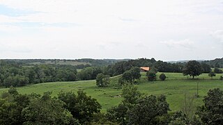
Denver is a community in Carroll County in northwest Arkansas, United States. Denver is located on the east bank of Long Creek near the confluence of Dry Creek with Long Creek and approximately one mile west of the Carroll-Boone county line. The community is accessed by county road from Arkansas Highway 396, which passes about 1.5 miles to the north. Farewell is about three miles to the west.
Yocum is a community in Carroll County in northwest Arkansas, United States. The community is located on Arkansas Highway 103 and the west bank of Yocum Creek. The site is three miles southeast of Oak Grove and six miles north of Green Forest.
Rudd also known as Piney is an unincorporated community in southern Carroll County, Arkansas, United States. The community is located among mountain peaks along Piney Creek on Arkansas Highway 103. Gobbler lies to the southeast and Metalton lies to the northwest. The site is at an elevation of 1,447 ft (441 m).
Boston is an unincorporated community in the Boston Mountains of southeastern Madison County, Arkansas, United States. The community is located on Arkansas Highway 16 between Pettigrew to the southwest and Red Star to the northeast. The community is on a high ridge at an elevation of 2,329 feet (710 m). The location is at the headwaters of four streams: Kings River to the northeast, War Eagle Creek to the northwest, the White River to the east and southwest and Little Mulberry Creek to the southeast.
Piney Creek is a stream in southern Carroll County of the U.S. state of Arkansas. It is a tributary to the Kings River.
Osage Creek is a stream in Newton, Boone, and Carroll counties of northern Arkansas. It is a tributary of the Kings River.
The Little Black River is a stream in Ripley and Butler counties in southeast Missouri and Clay and Randolph counties of northeast Arkansas. It is a tributary to the Current River.
References
- ↑ U.S. Geological Survey Geographic Names Information System: Farewell, Arkansas
- ↑ Arkansas Atlas & Gazetteer, DeLorme, 2nd ed., 2004, p. 24 ISBN 0-89933-345-1
- ↑ History of Farewell
Municipalities and communities of Carroll County, Arkansas, United States | ||
|---|---|---|
| Cities | 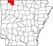 | |
| Towns | ||
| Townships | ||
| Unincorporated communities | ||
| Ghost towns | ||
| Footnotes | ‡This populated place also has portions in an adjacent county or counties | |
36°23′32″N93°22′11″W / 36.39222°N 93.36972°W
| | This article about a location in Carroll County, Arkansas is a stub. You can help Wikipedia by expanding it. |