This article has multiple issues. Please help improve it or discuss these issues on the talk page . (Learn how and when to remove these messages)
|
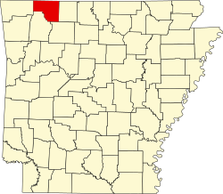
Coin Township | |
|---|---|
 Coin Township Location in Arkansas | |
| Coordinates: 36°19′22.46″N93°19′42.08″W / 36.3229056°N 93.3283556°W | |
| Country | |
| State | |
| County | Carroll |
| Area | |
• Total | 19.228 sq mi (49.80 km2) |
| • Land | 19.191 sq mi (49.70 km2) |
| • Water | 0.037 sq mi (0.10 km2) |
| Population (2010) | |
• Total | 655 |
| • Density | 34.13/sq mi (13.18/km2) |
| Time zone | UTC-6 (CST) |
| • Summer (DST) | UTC-5 (CDT) |
| Zip Code | 72611 (Alpena) |
| Area code | 870 |
Coin Township is one of twenty-one current townships in Carroll County, Arkansas, USA. Its population according to the 2020 census was 680, up from 655 at the 2010 census. [1] The town features a suburban rural mix feel and most residents own their homes. There are many retirees that live in Coin Township and they tend to be conservative. [2]