Greene County, Arkansas

Last updated

Greene County
Paragould AR 2011 06 23 002.jpg
Courthouse in Paragould
Map of Arkansas highlighting Greene County.svg
Location within the U.S. state of Arkansas
Arkansas in United States.svg
Arkansas's location within the U.S.
Coordinates: 36°06′21″N90°33′41″W / 36.105833333333°N 90.561388888889°W / 36.105833333333; -90.561388888889
CountryFlag of the United States.svg United States
StateFlag of Arkansas.svg  Arkansas
FoundedNovember 5, 1833
Named for Nathanael Greene
Seat Paragould
Largest cityParagould
Area
  Total580 sq mi (1,500 km2)
  Land578 sq mi (1,500 km2)
  Water1.9 sq mi (5 km2)  0.3%
Population
 (2020)
  Total45,736
  Density79/sq mi (30/km2)
Time zone UTC−6 (Central)
  Summer (DST) UTC−5 (CDT)
Congressional district 1st
Website county.arkansas.gov/greene/

Greene County is a county located in the U.S. state of Arkansas. As of the 2020 census, the population was 45,736. [1] The county seat is Paragould, [2] which sits atop Crowley's Ridge.

Contents

Greene County is included in Jonesboro–Paragould Combined Statistical Area.

History

The first settler in the area was Benjamin Crowley, who arrived from Kentucky in 1821 and made his home about 12 miles (19 km) west of Paragould.

Greene County was formed on November 5, 1833, out of portions of Lawrence County and originally contained parts of present Clay and Craighead counties. The county was named for Revolutionary War hero Nathanael Greene. The first county seat was in Benjamin Crowley's home. By 1836, when Arkansas became a state, the county seat was located in a settlement called "Paris" (not to be confused with present-day Paris, Arkansas).

In 1848 a national highway was made through the area, and the county seat was moved to Gainesville, which had a reputation as rather lawless. The seat remained there until 1883, when it was transferred to the new town of Paragould. The people in Gainesville opposed the move, and shots reportedly were fired, since tempers were high. The courthouse was built in 1888 and survives in downtown Paragould.

In the early 20th century, Clay, Greene, and Craighead counties had policies forbidding African Americans from living in the area. [3]

Geography

According to the U.S. Census Bureau, the county has a total area of 580 square miles (1,500 km2), of which 578 square miles (1,500 km2) is land and 1.9 square miles (4.9 km2) (0.3%) is water. [4]

Major highways

Adjacent counties

Demographics

Historical population
CensusPop.Note
1840 1,586
1850 2,59363.5%
1860 5,843125.3%
1870 7,57329.6%
1880 7,480−1.2%
1890 12,90872.6%
1900 16,97931.5%
1910 23,85240.5%
1920 26,1059.4%
1930 26,1270.1%
1940 30,20415.6%
1950 29,149−3.5%
1960 25,198−13.6%
1970 24,765−1.7%
1980 30,74424.1%
1990 31,8043.4%
2000 37,33117.4%
2010 42,09012.7%
2020 45,7368.7%
2023 (est.)46,743 [5] 2.2%
U.S. Decennial Census [6]
1790–1960 [7] 1900–1990 [8]
1990–2000 [9] 2010 [10]
Age pyramid Greene County USA Greene County, Arkansas age pyramid.svg
Age pyramid Greene County

2020 census

Greene County racial composition [12]
RaceNumberPercentage
White (non-Hispanic)40,50988.57%
Black or African American (non-Hispanic)9262.02%
Native American 1380.3%
Asian 1810.4%
Pacific Islander 2870.63%
Other/Mixed 2,0994.59%
Hispanic or Latino 1,5963.49%

As of the 2020 United States census, there were 45,736 people, 17,254 households, and 12,280 families residing in the city.

2010 census

As of the 2010 census, there were 42,090 people living in the county. The racial makeup of the county was 95.4% White, 0.6% Black, 0.5% Native American, 0.3% Asian, <0.1% Pacific Islander, <0.1% from some other race and 1.1% from two or more races. 2.1% were Hispanic or Latino of any race.

2000 census

As of the 2000 census, [13] there were 37,331 people, 14,750 households, and 10,708 families living in the county. The population density was 65 people per square mile (25 people/km2). There were 16,161 housing units at an average density of 28 units per square mile (11 units/km2). The racial makeup of the county was 97.45% White, 0.13% Black or African American, 0.42% Native American, 0.17% Asian, 0.02% Pacific Islander, 0.47% from other races, and 1.34% from two or more races. 1.16% of the population were Hispanic or Latino of any race.

There were 14,750 households, out of which 33.10% had children under the age of 18 living with them, 59.20% were married couples living together, 9.70% had a female householder with no husband present, and 27.40% were non-families. 24.00% of all households were made up of individuals, and 11.00% had someone living alone who was 65 years of age or older. The average household size was 2.49 and the average family size was 2.95.

In the county, the population was spread out, with 25.20% under the age of 18, 9.10% from 18 to 24, 28.70% from 25 to 44, 23.10% from 45 to 64, and 13.90% who were 65 years of age or older. The median age was 36 years. For every 100 females, there were 95.30 males. For every 100 females age 18 and over, there were 91.90 males.

The median income for a household in the county was $30,828, and the median income for a family was $37,316. Males had a median income of $27,535 versus $20,375 for females. The per capita income for the county was $16,403. About 9.90% of families and 13.30% of the population were below the poverty line, including 15.40% of those under age 18 and 12.80% of those age 65 or over.

Government

Over the past few election cycles, Greene County has swung hard towards the GOP. The last Democrat to carry this county was Al Gore in 2000. Twenty years later, Joe Biden failed to even garner twenty percent of the county's vote.

United States presidential election results for Greene County, Arkansas [14]
Year Republican Democratic Third party
No.%No.%No.%
2020 12,67078.70%3,05818.99%3722.31%
2016 10,72073.42%3,07121.03%8095.54%
2012 9,07165.92%4,00029.07%6905.01%
2008 8,57863.02%4,54133.36%4933.62%
2004 7,23751.86%6,56447.04%1541.10%
2000 5,83146.71%6,31950.62%3342.68%
1996 3,75732.68%6,62257.61%1,1169.71%
1992 3,51028.49%7,54161.20%1,27110.31%
1988 5,16150.06%5,06549.13%840.81%
1984 6,17956.17%4,73043.00%910.83%
1980 4,51441.64%5,99655.31%3313.05%
1976 2,69026.39%7,49573.54%70.07%
1972 6,12873.03%2,26326.97%00.00%
1968 2,85935.40%2,19727.20%3,02137.40%
1964 2,27132.27%4,74267.39%240.34%
1960 2,65847.73%2,77449.81%1372.46%
1956 1,89835.22%3,45464.09%370.69%
1952 1,87534.35%3,57165.43%120.22%
1948 50214.81%2,65778.38%2316.81%
1944 92826.51%2,56573.26%80.23%
1940 51018.65%2,22081.17%50.18%
1936 41218.48%1,81181.25%60.27%
1932 2747.65%3,27791.43%330.92%
1928 1,01141.27%1,42658.20%130.53%
1924 45623.57%1,14859.33%33117.11%
1920 1,07235.53%1,86561.82%802.65%
1916 53318.87%2,29281.13%00.00%
1912 28614.05%1,25161.47%49824.47%
1908 54924.48%1,60671.60%883.92%
1904 40929.45%92266.38%584.18%
1900 41927.44%1,09171.45%171.11%
1896 26213.79%1,62785.63%110.58%

Communities

Cities

Towns

Unincorporated communities

Townships

Townships in Greene County, Arkansas as of 2010 Greene County Arkansas 2010 Township Map large.jpg
Townships in Greene County, Arkansas as of 2010

Townships in Arkansas are the divisions of a county. Each township includes unincorporated areas; some may have incorporated cities or towns within part of their boundaries. Arkansas townships have limited purposes in modern times. However, the United States census does list Arkansas population based on townships (sometimes referred to as "county subdivisions" or "minor civil divisions"). Townships are also of value for historical purposes in terms of genealogical research. Each town or city is within one or more townships in an Arkansas county based on census maps and publications. The townships of Greene County are listed below; listed in parentheses are the cities, towns, and/or census-designated places that are fully or partially inside the township. [15] [16]

Education

School districts include: [17]

Former districts:

See also

Related Research Articles

<span class="mw-page-title-main">Clay County, Arkansas</span> County in Arkansas, United States

Clay County is a county located in the U.S. state of Arkansas. Originally incorporated as Clayton County, as of the 2020 census, its population was 14,552. The county has two county seats, Corning and Piggott. It is a dry county, in which the sale of alcoholic beverages is restricted or prohibited.

<span class="mw-page-title-main">Randolph County, Arkansas</span> County in Arkansas, United States

Randolph County is located between the Ozark Mountains and Arkansas Delta in the U.S. state of Arkansas. The county is named for John Randolph, a U.S. senator from Virginia influential in obtaining congressional approval of the Louisiana Purchase, which includes today's Randolph County. Created as Arkansas's 32nd county on October 29, 1835, Randolph County has two incorporated cities, including Pocahontas, the county seat and most populous city. The county is also the site of numerous unincorporated communities and ghost towns.

<span class="mw-page-title-main">Poinsett County, Arkansas</span> County in Arkansas, United States

Poinsett County is a county located in the U.S. state of Arkansas. As of the 2020 census, the population was 22,965. The county seat is Harrisburg. Poinsett County is included in the Jonesboro–Paragould Combined Statistical Area.

<span class="mw-page-title-main">Mississippi County, Arkansas</span> County in Arkansas, United States

Mississippi County is the easternmost county in the U.S. state of Arkansas. As of the 2020 census, the population was 40,685. There are two county seats, Blytheville and Osceola. The county is named for the Mississippi River which borders the county to the east. Mississippi County is part of the First Congressional District in Arkansas.

<span class="mw-page-title-main">Lawrence County, Arkansas</span> County in Arkansas, United States

Lawrence County is a county located in the U.S. state of Arkansas. As of the 2020 census, the population was 16,216. The county seat is Walnut Ridge. Lawrence County is Arkansas's second county, formed on January 15, 1815, and named for Captain James Lawrence who fought in the War of 1812. It is an alcohol prohibition or dry county.

<span class="mw-page-title-main">Craighead County, Arkansas</span> County in Arkansas, United States

Craighead County is a county located in the U.S. state of Arkansas. As of the 2020 census, the population was 111,231. The county has two county seats — Jonesboro and Lake City. Craighead County is Arkansas's 58th county, formed on February 19, 1859, and named for state Senator Thomas Craighead. It is one of several dry counties within the state of Arkansas, in which the sale of alcoholic beverages is largely prohibited.

<span class="mw-page-title-main">Peach Orchard, Arkansas</span> City in Arkansas, United States

Peach Orchard is a city in Clay County, Arkansas, United States. The population was 135 at the 2010 census.

<span class="mw-page-title-main">Piggott, Arkansas</span> City in Arkansas, United States

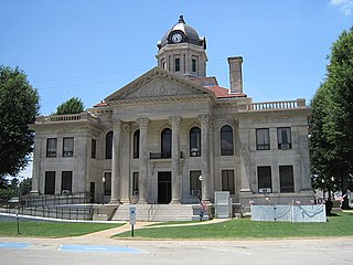
Piggott is a city in Clay County, Arkansas, United States. It is one of the two county seats of Clay County, along with Corning. It is the northern terminus of the Arkansas segment of the Crowley's Ridge Parkway, a National Scenic Byway. As of the 2010 census, Piggott's population was 3,849. The town was named after James A. Piggott, one of the early settlers and initiator of the local post office.

<span class="mw-page-title-main">Rector, Arkansas</span> City in Arkansas, United States

Rector is a city in southeastern Clay County, Arkansas, United States. The population was 1,977 at the 2010 census.

<span class="mw-page-title-main">Brookland, Arkansas</span> City in Arkansas, United States

Brookland is a city in Craighead County, Arkansas, United States. The population was 1,642 at the 2010 census. It is included in the Jonesboro, Arkansas Metropolitan Statistical Area.

<span class="mw-page-title-main">Jonesboro, Arkansas</span> City in Northeast Arkansas

Jonesboro is a city located on Crowley's Ridge in the northeastern corner of the U.S. State of Arkansas. Jonesboro is one of two county seats of Craighead County. In 2022, the city had an estimated population of 79,876, making it the fifth-most populous city in Arkansas. In 2020, the Jonesboro metropolitan area had a population of 134,196, and the Jonesboro-Paragould Combined Statistical Area had a population of 179,932.

<span class="mw-page-title-main">Delaplaine, Arkansas</span> Town in Arkansas, United States

Delaplaine is a town in Greene County, Arkansas, United States. The population was 116 at the time of the 2010 census.

<span class="mw-page-title-main">Lafe, Arkansas</span> Town in Arkansas, United States

Lafe is a town in Greene County, Arkansas, United States on Crowley's Ridge. The population was 448 at the 2010 census, up from 385 in 2000.

<span class="mw-page-title-main">Marmaduke, Arkansas</span> City in Arkansas, United States

Marmaduke is a city in Greene County, Arkansas, United States. The population was 1,212 in 2020.

<span class="mw-page-title-main">Oak Grove Heights, Arkansas</span> City in Arkansas, United States

Oak Grove Heights is a city in Greene County, Arkansas, United States. The population was 889 at the 2010 census.

<span class="mw-page-title-main">Paragould, Arkansas</span> City in Arkansas, United States

Paragould is the county seat of Greene County, and the 19th-largest city in Arkansas, in the United States. The city is located in northeastern Arkansas on the eastern edge of Crowley's Ridge, a geologic anomaly contained within the Arkansas delta.

<span class="mw-page-title-main">O'Kean, Arkansas</span> Town in Arkansas, United States

O'Kean is a town in Randolph County, Arkansas, United States. The population was 192 at the 2020 census.

<span class="mw-page-title-main">Jonesboro–Paragould combined statistical area</span> Statistical Area

The Jonesboro–Paragould Combined Statistical Area is made up of three counties in northeastern Arkansas. The CSA consists of the Jonesboro Metropolitan Statistical Area and the Paragould Micropolitan Statistical Area. As of the 2010 census, the CSA had a population of 163,116.

Greene County Tech High School (GCTHS) is a comprehensive public high school located in Paragould, Arkansas, United States. It is one of two public high schools in Greene County, Arkansas, along with cross-town rival Paragould High School, and is the sole high school managed by the Greene County Tech School District. It serves as the main feeder school for Greene County Tech Junior High School.

Greene County Technical School District is a public school district based in Paragould, Arkansas, United States. The school district encompasses 344.38 square miles (891.9 km2) of land, including portions of Greene County, Randolph County, Craighead County, and Clay County.

References

  1. "Census - Geography Profile: Greene County, Arkansas". United States Census Bureau . Retrieved January 20, 2023.
  2. "Find a County". National Association of Counties. Archived from the original on May 31, 2011. Retrieved June 7, 2011.
  3. Neville, A. W. (March 2, 1945). "Backward Glances". The Paris News. Paris, Texas. p. 4 via Newspapers.com. On the survey from Bird's Point, Mo., to Jonesboro, Ark., I had a Negro cook. As Negroes were not allowed to live in Clay, Greene and Craighead Counties, Ark., my cook was a curiosity to the children. The women used to bring the children to camp to see him.
  4. "2010 Census Gazetteer Files". United States Census Bureau. August 22, 2012. Retrieved August 26, 2015.
  5. "Annual Estimates of the Resident Population for Counties: April 1, 2020 to July 1, 2023". United States Census Bureau. Retrieved March 30, 2024.
  6. "U.S. Decennial Census". United States Census Bureau. Retrieved August 26, 2015.
  7. "Historical Census Browser". University of Virginia Library. Retrieved August 26, 2015.
  8. Forstall, Richard L., ed. (March 27, 1995). "Population of Counties by Decennial Census: 1900 to 1990". United States Census Bureau. Retrieved August 26, 2015.
  9. "Census 2000 PHC-T-4. Ranking Tables for Counties: 1990 and 2000" (PDF). United States Census Bureau. April 2, 2001. Archived (PDF) from the original on March 27, 2010. Retrieved August 26, 2015.
  10. "State & County QuickFacts". United States Census Bureau. Archived from the original on June 7, 2011. Retrieved May 21, 2014.
  11. Based on 2000 census data
  12. "Explore Census Data". data.census.gov. Retrieved December 30, 2021.
  13. "U.S. Census website". United States Census Bureau . Retrieved May 14, 2011.
  14. "Dave Leip's Atlas of U.S. Presidential Elections" . Retrieved November 18, 2016.
  15. 2011 Boundary and Annexation Survey (BAS): Greene County, AR (PDF) (Map). U. S. Census Bureau. Archived from the original (PDF) on October 19, 2012. Retrieved August 9, 2011.
  16. "Arkansas: 2010 Census Block Maps - County Subdivision". United States Census Bureau . Retrieved May 28, 2014.
  17. "2020 CENSUS - SCHOOL DISTRICT REFERENCE MAP: Greene County, AR" (PDF). U.S. Census Bureau. Archived (PDF) from the original on October 6, 2022. Retrieved August 5, 2022. - Text list
  18. 1 2 3 Home. Paragould School District. February 11, 1997. Retrieved on October 14, 2017. "Paragould School District is a consolidated district comprising the former districts of Oak Grove, Stanford, and Paragould."
  19. 1 2 3 4 "ConsolidationAnnex_from_1983.xls." Arkansas Department of Education. Retrieved on October 13, 2017.

36°06′21″N90°33′41″W / 36.10583°N 90.56139°W / 36.10583; -90.56139