 | |
|---|---|
| Highway system | |
Several special routes of U.S. Route 49 exist. In order from south to north they are as follows.
| | |
|---|---|
| Highway system | |
Several special routes of U.S. Route 49 exist. In order from south to north they are as follows.

U.S. Highway 49B | |
|---|---|
| Location | Helena-West Helena, Arkansas |
| Length | 6.92 mi [1] (11.14 km) |
| Existed | June 24, 1970 [2] –present |
U.S. Highway 49 Business (US 49B, Hwy. 49B) is a 6.92-mile (11.14 km) business route of U.S. Route 49 in Phillips County. [3]
The route's northern terminus is at US 49 in Helena-West Helena. It runs south as Sebastian Street and splits into two divided one-way streets known as Plaza Avenue at a junction Highway 242. These routes overlap for 0.13 miles (0.21 km) until Highway 242 turns north along 4th Street, where a concurrency with Crowley's Ridge Parkway (CRP). The one-way streets merge and become Richmond Drive headed east. US 49B passes the Faust House, Myers House, Central High School and the Helena Country Club before meeting the former corporate limit of West Helena prior to their 2005 merger. The route winds and splits into two divided one-way streets begin as it enters the area formerly designated as Helena. After a junction with Highway 185 the routes pass several historical properties on the National Register of Historic Places, including the Altman House, Beech Street Historic District, James C. Tappan House, Coolidge House, and the Jerome Bonaparte Pillow House. Highway 49B turns south onto Columbia Street, with CRP continuing eastbound on city streets toward the business district, while also intersecting the Great River Road, which runs northbound on Columbia Street and eastbound on Perry Street. US 49B runs south past the Allin House, William Nicholas Straub House, Centennial Baptist Church, and the St. Mary's Catholic Church. The route continues south past the Keesee House, William A. Short House, and Estevan Hall before becoming Biscoe Street and terminating at the parent route.
The route was designated June 24, 1970 following completion of a US 49 bypass around Helena and West Helena. The former US 49 alignment through downtown Helena and West Helena was assigned the US 49B designation. [2]
Major intersections
The entire route is in Helena-West Helena, Phillips County.
| mi [3] | km | Destinations | Notes | ||
|---|---|---|---|---|---|
| 0.00 | 0.00 | Northern terminus | |||
| 1.36– 1.49 | 2.19– 2.40 | Begin CRP overlap | |||
| 4.33 | 6.97 | AR 185 northern terminus | |||
| End CRP overlap | |||||
| 6.92 | 11.14 | Southern terminus | |||
1.000 mi = 1.609 km; 1.000 km = 0.621 mi
| |||||
U.S. Highway 49B | |
|---|---|
| Location | Brookland, Arkansas |
| Length | 3.66 mi [1] (5.89 km) |
| Existed | July 28, 2000 [4] –present |
U.S. Highway 49 Business (US 49B and Hwy. 49B) is a 3.66-mile (5.89 km) business route of U.S. Route 49 in Craighead County. [5] The route's southern terminus is at US 49 and Highway 1 (AR 1) in south Brookland. It runs north as Holman Street, passing the Brookland City Hall and Brookland High School. North of the high school, US 49B runs due north to meet Arkansas Highway 230 and eventually intersect US 49/AR 1 to terminate.
This roadway was originally part of AR 1, designated in 1926 in Arkansas's initial state highway system. US 49 overlapped AR 1 through the area after extension in 1978.
Major intersections
The entire route is in Brookland, Craighead County.
| mi [5] | km | Destinations | Notes | ||
|---|---|---|---|---|---|
| 0.00 | 0.00 | Southern terminus | |||
| 2.37 | 3.81 | AR 230 western terminus | |||
| 3.66 | 5.89 | Northern terminus | |||
| 1.000 mi = 1.609 km; 1.000 km = 0.621 mi | |||||
U.S. Highway 49B | |
|---|---|
| Location | Paragould, Arkansas |
| Length | 2.36 mi [1] (3.80 km) |
| Existed | August 22, 1979 [6] –present |
U.S. Highway 49 Business (US 49B and Hwy. 49B) is a 2.36-mile (3.80 km) business route of U.S. Route 49 in Greene County. [7] Posted as US 49B, the route's northern terminus is at US 49 in north Paragould. It runs south and intersects AR 135 near the Greene County Fairgrounds. The route continues south as 3rd Street, passing near the historic National Bank of Commerce Building, the Paragould War Memorial, the Paragould Downtown Commercial Historic District, and the Gulf Oil Company Service Station to terminate at US 412.
Following the designation of Highway 1 as US 49 between Jonesboro and Piggott, AR 1B in Paragould was redesignated as US 49B on August 22, 1979. [6]
Major intersections
The entire route is in Paragould, Greene County.
| mi [7] | km | Destinations | Notes | ||
|---|---|---|---|---|---|
| 0.0 | 0.0 | Northern terminus | |||
| 0.99 | 1.59 | AR 135 southern terminus | |||
| 2.36 | 3.80 | Begin US 412/CRP overlap | |||
| Southern terminus, end US 412 overlap | |||||
1.000 mi = 1.609 km; 1.000 km = 0.621 mi
| |||||
Court Street | |
|---|---|
| Location | Paragould, Arkansas |
| Length | 0.379 mi [8] (610 m) |
| Existed | March 18, 1981 [9] –present |
U.S. Highway 49Y (US 49Y, Hwy. 49Y, and Court Street, formerly AR 1Y and AR 25Y) is a short connector route in Paragould, Arkansas. It is maintained by the Arkansas Department of Transportation (ArDOT). Highway 49Y begins at US 49 and Highway 1 (Linwood Drive) west of downtown Paragould. The highway runs due west, with the Paragould High School on the north side of the road and an industrial area along the south side. US 49Y terminates at US Highway 412 Business (US 412B) and the Crowley's Ridge Parkway (Kingshighway) just south of Kirk Field. [10]
The ArDOT maintains US 49Y like all other parts of the state highway system. As a part of these responsibilities, the Department tracks the volume of traffic using its roads in surveys using a metric called average annual daily traffic (AADT). ArDOT estimates the traffic level for a segment of roadway for any average day of the year in these surveys. As of 2020, AADT was estimated to be 8,900 vehicles per day (VPD). [11]
In a May 1963 Arkansas Highway Department report, an unsigned section of state highway along Court Street in Paragould between 15th Street and Second Street was identified for deletion from the state highway system. In May 1968, the City of Paragould requested exchanging this roadway for a new state highway designation along Court Street between Highway 25 and a newly constructed Highway 1 (15th Street). The Highway Commission agreed to the request on June 26, 1968, designating it as Highway 1Y and declaring it would "provide a desirable connection between the two State Highways and would eliminate indirection of travel to motorists". [12] The designation was renumbered to Highway 25Y in 1979 when Highway 1B became US 49B. [6]
After US 412 supplanted Highway 25 between Walnut Ridge and Missouri in 1980, the highway was renumbered US 49Y. [13]
Major intersections
The entire route is in Paragould, Greene County.
| mi [8] | km | Destinations | Notes | ||
|---|---|---|---|---|---|
| 0.000 | 0.000 | Eastern terminus | |||
| 0.379 | 0.610 | Western terminus | |||
| 1.000 mi = 1.609 km; 1.000 km = 0.621 mi | |||||
U.S. Highway 49 Business | |
|---|---|
| Location | Hattiesburg, Mississippi |
| | This section needs expansion. You can help by adding to it. (January 2011) |
U.S. Highway 49E Business | |
|---|---|
| Location | Greenwood, Mississippi |
| | This section needs expansion. You can help by adding to it. (January 2011) |
U.S. Highway 49B | |
|---|---|
| Location | Jonesboro, Arkansas |
| Length | 5.2 mi [14] (8.4 km) |
| Existed | June 25, 1979 [15] –November 26, 1996 [16] |
U.S. Highway 49 Business (US 49B and Hwy. 49B) is a former 5.2-mile (8.4 km) business route of U.S. Route 49 in Craighead County. [14]
The route was created following an Arkansas State Highway Commission request to extend US 49 along Highway 1 between Jonesboro and Piggott. [17] It was approved by the United States Route Number Committee of American Association of State Highway and Transportation Officials (AASHTO) on June 25, 1979. [15] It was truncated at the end of the one-way pair in downtown Jonesboro near Cate Street on April 25, 1996. [18] The remainder was deleted eight months later, with pieces redesignated as Highway 18, Highway 141, and US 63B. [16]
Major intersections
The entire route was in Jonesboro, Craighead County.
| mi [5] | km | Destinations | Notes | ||
|---|---|---|---|---|---|
| 0.0 | 0.0 | Southern terminus | |||
| 1.3 | 2.1 | Begin US 63B/AR 18 overlap | |||
| 2.9 | 4.7 | End US 63B/AR 18 overlap, AR 141 southern terminus | |||
| 5.2 | 8.4 | Northern terminus | |||
1.000 mi = 1.609 km; 1.000 km = 0.621 mi
| |||||
Highway 43 is a designation for three north–south state highways in Arkansas. One segment of 27.1 miles (43.6 km) runs from Highway 264 in Siloam Springs north into Delaware County, Oklahoma along Oklahoma State Highway 20 (SH-20) to terminate at Missouri Route 43 (Route 43) at the Missouri/Oklahoma/Arkansas tri-point near Southwest City, Missouri. A second segment of 20.0 miles (32.2 km) runs northeast from Highway 21 at Boxley to Highway 7 in Harrison. The third segment runs 1.8 miles (2.9 km) north in Harrison from US Route 65 (US 65) to Highway 7.
Highway 392 is a 10.44-mile (16.80 km) state highway in the Ozark Mountains in northern Arkansas. The highway runs from U.S. Highway 62 (US 62) and US 412 in Little Arkansaw east to AR 7 in Harrison. The route is located entirely in Boone County, and also serves the communities of Batavia and Capps. AR 392 is maintained by the Arkansas Department of Transportation.

Highway 41 is a designation for two state highways in Western Arkansas. One route of 18.02 miles (29.00 km) runs from Franklin County Route 40 (CR 40) south to Highway 23 near Chismville. A second routing begins at US Route 70B (US 70B) in De Queen and runs south to Texas State Highway 8 at the Texas state line. The northern segment of Highway 41 contains a 0.60 miles (0.97 km) officially designated exception over Highway 22 in Branch.

Highway 8 is an east–west state highway in Lower Arkansas. The route of 229.83 miles (369.88 km) runs from Oklahoma State Highway 63 (SH-63) at the Oklahoma state line east across the state to US Route 65 (US 65) south of Eudora.

Highway 69 is a designation for three north–south state highways in northeast Arkansas. A western route of 57.64 miles (92.76 km) runs south from Highway 9 at Melbourne to Highway 14/Highway 367 in Newport. A second route of 15.31 miles (24.64 km) begins at Highway 163 and runs north through Trumann to Highway 158 at Lunsford. A third route begins at U.S. Route 49/Highway 1 (US 49/AR 1) at the city limits of Paragould and runs north to terminate at US 412B in the city.
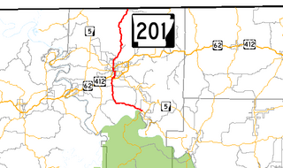
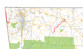
Highway 201 is a north–south state highway in Baxter County, Arkansas. The route runs 24.05 miles (38.70 km) from Arkansas Highway 341 in Salesville north to the Missouri state line through Mountain Home, the county seat of Baxter County.

Highway 135 is a north–south state highway in northeast Arkansas. The route of 69.67 miles (112.12 km) runs from US Route 63 (US 63) near Tyronza north through Paragould to US 62.

Highway 141 is designation for two north–south state highways in Northeast Arkansas. The longer segment was created in 1931 and extended throughout the mid-20th century to the current alignment connecting Jonesboro and points north. The Jonesboro segment was a former city street added to the state highway system in 1973. Both are maintained by the Arkansas Department of Transportation.

Highway 18 is an east–west state highway of 93.43 miles (150.36 km) in Northeast Arkansas.
Sixteen special routes of U.S. Route 62 currently exist. Seven of them lie within the state of Arkansas. Three existed in the past but have since been decommissioned.
Ten special routes of U.S. Route 63 currently exist. Five of them lie within the state of Arkansas. There are also four former routings that have been removed from the system.

Highway 75 is a north–south state highway in the Arkansas Delta. The route runs from Highway 38/Highway 50 north to Interstate 555/AR 14 in Marked Tree. Created during the initial 1926 Arkansas state highway numbering, Highway 75 has been shortened and extended over roughly the same alignment over its lifetime. The highway has one spur route, Highway 75 Spur in the small town of Parkin. Both highways are maintained by the Arkansas Department of Transportation (ArDOT).
Highway 227 is a designation for two north–south state highways in Garland County, Arkansas. One segment of 7.43 miles (11.96 km) runs north from US Highway 70 (US 70) to US 270. A second route of 11.74 miles (18.89 km) begins at US 270 at Piney and runs north to Lake Ouachita State Park. Both routes are maintained by the Arkansas Department of Transportation (ARDOT).
Highway 335 is a north–south state highway in Union County, Arkansas. The highway begins at Highway 15 and runs northeast to U.S. Highway 167 (US 167). It is maintained by the Arkansas Department of Transportation (ArDOT).
Highway 302 is a designation for three east–west state highways in the Arkansas Grand Prairie. All three are low traffic rural highways. The first segment was created in 1963, with the other two added ten years later. One segment was part of the Trail of Tears and is preserved as an Arkansas Heritage Trail. All are maintained by the Arkansas Department of Transportation (ArDOT).
Highway 130 is an east–west state highway in Arkansas County, Arkansas. Mostly a low-volume, two-lane road, Highway 130 connects the two county seats of Arkansas County, Stuttgart and DeWitt. The highway began as State Road 30, one of the original state highways in 1926 between North Little Rock and DeWitt. It was renumbered to 130 to prevent confusion with Interstate 30 in 1958, and the segment between North Little Rock and Stuttgart was replaced by an extension of US 165 in 1981, producing the current alignment. Highway 130 has one spur route in Almyra, and a former alternate route in DeWitt that was designated but never built. The routes are maintained by the Arkansas Department of Transportation (ARDOT).
Highway 369 is a designation for three north–south state highways in Arkansas. All are maintained by the Arkansas Department of Transportation (ArDOT). One segment provides connectivity in the Ouachita Mountains, with the other two serving as short industrial access roads. The longest segment was designated in 1966 and extended thrice, with the two industrial access roads created in 1978 and 1980. All three segments are maintained by the Arkansas Department of Transportation (ArDOT).
Highway 173 is a former state highway in Craighead County, Arkansas. Between designation as a state highway in 1940 and decommissioning to the city street system in 1979, it was maintained by the Arkansas Highway Department (AHD), now known as the Arkansas Department of Transportation (ArDOT).
Highway 156 is a former state highway in Prairie Grove, Arkansas. Between 1980 and 2007, the highway was maintained by the Arkansas State Highway and Transportation Department (AHTD), now known as the Arkansas Department of Transportation (ArDOT).
{{cite map}}: |author= has generic name (help){{cite map}}: |author= has generic name (help)