Cardwell, Missouri

Last updated

Cardwell, Missouri
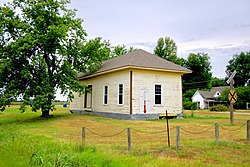
Cardwell-Depot-mo.jpg
Cotton Belt Depot in Cardwell, MO
Dunklin County Missouri Incorporated and Unincorporated areas Cardwell Highlighted.svg
Location of Cardwell, Missouri
Coordinates: 36°2′50″N90°17′33″W / 36.04722°N 90.29250°W / 36.04722; -90.29250
Country United States
State Missouri
County Dunklin
First settled1895
Incorporated1904
Named for Frank Cardwell
Government
  MayorMike Clark
Area
[1]
  Total
0.63 sq mi (1.63 km2)
  Land0.63 sq mi (1.63 km2)
  Water0.00 sq mi (0.00 km2)
Elevation
[2]
249 ft (76 m)
Population
 (2020)
  Total
561
  Density890.48/sq mi (343.92/km2)
Time zone UTC-6 (Central (CST))
  Summer (DST) UTC-5 (CDT)
ZIP code
63829
Area code 573
FIPS code 29-11350 [3]
GNIS feature ID2393741 [2]

Cardwell is a city in southwest Dunklin County, Missouri, United States. The 2024 recorded population is 526. The community was named after Frank Cardwell, an Arkansas banker who lent money to the town's founders. [4] [5] The current mayor of Cardwell is Mike Clark and the current aldermen are Harvey Beasley, Randall Duda, Sherry Horner, and Randy Dunigan. Kim Heit serves as the City Clerk. [6]

Contents

History

On January 1, 1893, the Paragould Southeastern Railway, originally a tramway, began construction to extend its mainline from Paragould, Arkansas eastward into the Missouri Bootheel. [7] By November 1894, the line had been graded to the new townsite and it was being advertised in local papers that plotts were being sold. [8] On January 19, 1895, the first train was reported to have arrived in Cardwell, and platting continued into the following year by the Bertig family of Paragould, AR, and a post office was established soon after. [4] [9] [10] [11] [12] A school district was established for Cardwell in 1899, and that July a contract was let for the construction of a two story brick school building. [13]

In 1902, the Paragould and Memphis Railroad, a "tap line" built a link between Cardwell and Manila, AR. This line was mostly used to haul lumber. [14] In 1904, the city of Cardwell was formally incorporated. [15]

Geography

Cardwell is situated in the southwestern corner of Missouri's Bootheel, with the Missouri-Arkansas state line lying both to the west and south. Missouri Route 164 traverses Cardwell, connecting the city with Arbyrd and Hornersville to the east. U.S. Route 412 passes just south and east of Cardwell. Paragould, Arkansas is ten miles to the west on Route 412. The St. Francis River follows the state line two miles to the west of the community. [16]

According to the United States Census Bureau, the city has a total area of 0.63 square miles (1.63 km2), all land. [17]

Climate

Cardwell experiences a humid subtropical climate, with hot summers and generally cold winters.

Climate data for Cardwell, Missouri
MonthJanFebMarAprMayJunJulAugSepOctNovDecYear
Mean daily maximum °F (°C)46
(8)
51
(11)
61
(16)
71
(22)
80
(27)
88
(31)
91
(33)
90
(32)
84
(29)
73
(23)
60
(16)
49
(9)
70
(21)
Mean daily minimum °F (°C)29
(−2)
33
(1)
41
(5)
50
(10)
60
(16)
68
(20)
71
(22)
70
(21)
62
(17)
50
(10)
40
(4)
32
(0)
51
(10)
Average precipitation inches (mm)3.3
(84)
4.1
(100)
4.7
(120)
5.2
(130)
5.2
(130)
3.5
(89)
3.8
(97)
3.4
(86)
3.2
(81)
4.3
(110)
5.0
(130)
4.9
(120)
50.6
(1,277)
Source: https://www.ncdc.noaa.gov

Demographics

Historical population
CensusPop.Note
1900 502
1910 87474.1%
1920 1,04319.3%
1930 861−17.4%
1940 9136.0%
1950 9524.3%
1960 816−14.3%
1970 8595.3%
1980 831−3.3%
1990 792−4.7%
2000 789−0.4%
2010 713−9.6%
2020 561−21.3%
source: [18]

2010 census

As of the census [19] of 2010, there were 713 people, 317 households, and 180 families residing in the city. The population density was 1,131.7 inhabitants per square mile (437.0/km2). There were 386 housing units at an average density of 612.7 per square mile (236.6/km2). The racial makeup of the city was 96.35% White, 0.42% Black or African American, 0.28% Native American, 1.12% from other races, and 1.82% from two or more races. Hispanic or Latino of any race were 3.37% of the population.

There were 317 households, of which 30.6% had children under the age of 18 living with them, 31.5% were married couples living together, 17.0% had a female householder with no husband present, 8.2% had a male householder with no wife present, and 43.2% were non-families. 36.0% of all households were made up of individuals, and 12.6% had someone living alone who was 65 years of age or older. The average household size was 2.25 and the average family size was 2.95.

The median age in the city was 39.5 years. 25% of residents were under the age of 18; 9.1% were between the ages of 18 and 24; 24.2% were from 25 to 44; 25.1% were from 45 to 64; and 16.5% were 65 years of age or older. The gender makeup of the city was 50.2% male and 49.8% female.

2000 census

As of the census [3] of 2000, there were 789 people, 345 households, and 218 families residing in the city. The population density was 1,246.1 inhabitants per square mile (481.1/km2). There were 387 housing units at an average density of 611.2 per square mile (236.0/km2). The racial makeup of the city was 97.34% White, 0.89% African American, 0.63% Native American, and 1.14% from two or more races. Hispanic or Latino of any race were 1.01% of the population.

There were 345 households, out of which 29.6% had children under the age of 18 living with them, 45.5% were married couples living together, 13.3% had a female householder with no husband present, and 36.8% were non-families. 33.6% of all households were made up of individuals, and 16.5% had someone living alone who was 65 years of age or older. The average household size was 2.29 and the average family size was 2.92.

In the city the population was spread out, with 24.3% under the age of 18, 7.5% from 18 to 24, 28.6% from 25 to 44, 22.6% from 45 to 64, and 17.0% who were 65 years of age or older. The median age was 39 years. For every 100 females, there were 88.3 males. For every 100 females age 18 and over, there were 86.0 males.

The median income for a household in the city was $21,042, and the median income for a family was $27,361. Males had a median income of $25,179 versus $19,500 for females. The per capita income for the city was $12,207. About 25.1% of families and 27.0% of the population were below the poverty line, including 34.0% of those under age 18 and 22.7% of those age 65 or over.
Education

Southland C-9 School District operates two schools at Cardwell: Southland Elementary School and Southland High School. [20]

Cardwell has a public library, a branch of the Dunklin County Library. [21]

Related Research Articles

<span class="mw-page-title-main">Dunklin County, Missouri</span> County in Missouri, United States

Dunklin County is located in the Bootheel of the U.S. state of Missouri. As of the 2020 census, the population was 28,283. The largest city and county seat is Kennett.

<span class="mw-page-title-main">Greene County, Arkansas</span> County in Arkansas, United States

Greene County is a county located in the U.S. state of Arkansas. As of the 2020 census, the population was 45,736. The county seat is Paragould, which sits atop Crowley's Ridge. Greene County is included in Jonesboro–Paragould Combined Statistical Area.

<span class="mw-page-title-main">Brookland, Arkansas</span> City in Arkansas, United States

Brookland is a city in Craighead County, Arkansas, United States. The population was 1,642 at the 2010 census. It is included in the Jonesboro, Arkansas Metropolitan Statistical Area.

<span class="mw-page-title-main">Marmaduke, Arkansas</span> City in Arkansas, United States

Marmaduke is a city in Greene County, Arkansas, United States. The population was 1,212 in 2020.

<span class="mw-page-title-main">Paragould, Arkansas</span> City in Arkansas, United States

Paragould is the county seat of Greene County, and the 19th-largest city in Arkansas, in the United States. The city is located in northeastern Arkansas on the eastern edge of Crowley's Ridge, a geologic anomaly contained within the Arkansas Delta.

<span class="mw-page-title-main">Arbyrd, Missouri</span> City in Missouri, United States

Arbyrd is a small town in southeast Dunklin County, Missouri, United States. The population was 404 at the 2020 census. The town was officially incorporated in 1919.

<span class="mw-page-title-main">Campbell, Missouri</span> City in Missouri, United States

Campbell is a city in northern Dunklin County, Missouri, United States. The population was 1,992 at the 2010 census.

<span class="mw-page-title-main">Clarkton, Missouri</span> City in Missouri, United States

Clarkton is a city in Dunklin County, Missouri, United States. The population was 1,288 at the 2010 census. Clarkton is the oldest city in Dunklin County.

<span class="mw-page-title-main">Holcomb, Missouri</span> City in Missouri, United States

HolcombHAW-kəm is a city in Dunklin County, Missouri, United States. The population was 635 at the 2010 census.

<span class="mw-page-title-main">Malden, Missouri</span> City in Missouri, United States

Malden is a city in the northeast corner of Dunklin County, Missouri, United States, located near the intersection of Missouri Route 25 and U.S. Route 62. The population was 4,277 at the 2010 census. Malden is within Missouri's 8th congressional district.

<span class="mw-page-title-main">Rives, Missouri</span> Village in Missouri, United States

Rives is a town in Dunklin County, Missouri, United States. The population was 63 at the 2010 census.

<span class="mw-page-title-main">Senath, Missouri</span> City in Missouri, United States

Senath is a city in Dunklin County, Missouri, United States. The population was 1,767 at the 2010 census.

<span class="mw-page-title-main">Horine, Missouri</span> Census-designated place in Missouri, United States

Horine is an unincorporated community and census-designated place (CDP) in Jefferson County, Missouri, United States. The population was 821 at the 2010 census, down from 923 in 2000.

<span class="mw-page-title-main">Pevely, Missouri</span> City in Missouri, United States

Pevely is a city in Jefferson County, Missouri, United States, and a suburb of St. Louis about 30 miles (48 km) south of St. Louis. The population was 6,012, at the 2020 United States Census.

<span class="mw-page-title-main">Stella, Missouri</span> Village in Missouri, United States

Stella is a village in southern Newton County, Missouri, United States. The population was 158 at the 2010 census. It is part of the Joplin, Missouri Metropolitan Statistical Area. The village of Stella is located 17 miles southeast of Neosho.

<span class="mw-page-title-main">Caruthersville, Missouri</span> City in Missouri, United States

Caruthersville is a city in and the county seat of Pemiscot County, Missouri, United States, located along the Mississippi River in the Bootheel region of the state's far southeast. The population was 5,562, according to the 2020 census.

<span class="mw-page-title-main">Cooter, Missouri</span> City in Missouri, United States

Cooter is a city in Pemiscot County, Missouri, United States. The population was 343 at the 2020 census.

<span class="mw-page-title-main">Steele, Missouri</span> City in Missouri, United States

Steele is a city in southern Pemiscot County in the Missouri Bootheel of southeastern Missouri, United States. The population was 1,853 at the 2020 census.

<span class="mw-page-title-main">Hornersville, Missouri</span> City in Missouri, United States

Hornersville is a city in Dunklin County, Missouri, United States, founded in 1840. The population was 537 at the 2020 census.

<span class="mw-page-title-main">Kennett, Missouri</span> City in Missouri, United States

Kennett is a city in and the county seat of Dunklin County, Missouri, United States. The city is located in the southeast corner of Missouri, 4 miles (6.4 km) east of Arkansas and 20 miles (32 km) from the Mississippi River. It had a population of 10,515 at the 2020 census. Kennett is the largest city in the Bootheel, a mostly agricultural area.

References

  1. "ArcGIS REST Services Directory". United States Census Bureau. Retrieved August 28, 2022.
  2. 1 2 U.S. Geological Survey Geographic Names Information System: Cardwell, Missouri
  3. 1 2 "U.S. Census website". United States Census Bureau . Retrieved January 31, 2008.
  4. 1 2 "Dunklin County Place Names, 1928–1945 (archived)". The State Historical Society of Missouri. Archived from the original on June 24, 2016. Retrieved September 29, 2016.{{cite web}}: CS1 maint: bot: original URL status unknown (link)
  5. Gannett, Henry (1905). The Origin of Certain Place Names in the United States. Govt. Print. Off. pp.  69.
  6. Police department questioned during Cardwell City Council meeting, Saturday, December 10, 2016 Jeff Dorris, Daily Dunklin Democrat
  7. "Valuation Docket No. 142, St. Louis Southwestern Railway Company, et al". April 26, 2024. Retrieved March 26, 2024.
  8. "Cardwell, Mo history". The Daily Dunklin Democrat. November 8, 1894. p. 4. Retrieved December 12, 2024.
  9. "Cardwell, One of Newest Towns in County Started as a Saw Mill Town". The Daily Dunklin Democrat. April 19, 1938. p. 52. Retrieved December 12, 2024.
  10. "Post Offices". Jim Forte Postal History. Retrieved September 29, 2016.
  11. Eaton, David Wolfe (1916). How Missouri Counties, Towns and Streams Were Named. The State Historical Society of Missouri. pp.  165.
  12. "First Train Expected at Cardwell, MO on Saturday". The Daily Dunklin Democrat. January 17, 1895. p. 4. Retrieved December 12, 2024.
  13. "Cardwell, Missouri". The Daily Dunklin Democrat. July 14, 1899. p. 3. Retrieved December 12, 2024.
  14. Tap Line Case 234 U.S. 1. 1914.{{cite book}}: |archive-url= requires |archive-date= (help)
  15. Douglass, Robert Sidney (1912). History of southeast Missouri : a narrative account of its historical progress, its people and its principal interests. Chicago: The Lewis Pub. Co.
  16. Missouri Atlas & Gazetteer, DeLorme, 1st ed., 1998, p. 70, ISBN   0899332242
  17. "US Gazetteer files 2010". United States Census Bureau. Archived from the original on July 2, 2012. Retrieved July 8, 2012.
  18. "Missouri Population 1900 - 1990" (PDF). Missouri Census Data Center. Archived from the original (CSV) on July 4, 2014. Retrieved October 6, 2014.
  19. "U.S. Census website". United States Census Bureau . Retrieved July 8, 2012.
  20. "Southland C-9 School District". Greatschools. Retrieved March 18, 2018.
  21. "Locations". Dunklin County Library. Retrieved March 17, 2018.