This article needs additional citations for verification .(March 2013) |
Brinkley, Arkansas | |
|---|---|
City | |
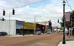 Downtown Brinkley | |
 Location in Monroe County, Arkansas | |
| Coordinates: 34°53′00″N91°11′34″W / 34.88333°N 91.19278°W | |
| Country | United States |
| State | Arkansas |
| County | Monroe |
| Area | |
• Total | 6.14 sq mi (15.91 km2) |
| • Land | 5.69 sq mi (14.73 km2) |
| • Water | 0.46 sq mi (1.18 km2) |
| Elevation | 200 ft (60 m) |
| Population | |
• Total | 2,700 |
• Estimate (2024) | 2,538 |
| • Density | 474.85/sq mi (183.35/km2) |
| Time zone | UTC-6 (Central (CST)) |
| • Summer (DST) | UTC-5 (CDT) |
| ZIP code | 72021 |
| Area code | 870 |
| FIPS code | 05-08950 |
| GNIS feature ID | 2403926 [2] |
| Website | cityofbrinkley |
Brinkley is the most populous city in Monroe County, Arkansas, United States. As of the 2020 census, the population was 2,700, [3] down from 3,188 in 2010.
Contents
- History
- Geography
- Climate
- Demographics
- 2020 Census
- 2000 Census
- Arts and culture
- Tourism
- Education
- Infrastructure
- Transportation
- Notable people
- See also
- References
- External links
Located within the Arkansas Delta, Brinkley was founded as a railroad town in 1872. The city has historically been a transportation and agricultural center in the region, more recently developing a reputation for outdoors recreation and the ivory-billed woodpecker. Birding has become important to the city and region following the purported discovery of the ivory-billed woodpecker in 2004, a species thought to be extinct 60 years earlier.
Located halfway between Little Rock and Memphis, the city has used the slogan "We'll Meet You Half-Way" in some of its advertising campaigns.[ citation needed ]


