Monroe, Arkansas | |
|---|---|
 Monroe  Monroe | |
| Coordinates: 34°44′03″N91°06′24″W / 34.73417°N 91.10667°W | |
| Country | United States |
| State | Arkansas |
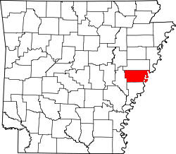
| Counties | Lee and Monroe |
| Area | |
• Total | 0.73 sq mi (1.9 km2) |
| • Land | 0.73 sq mi (1.9 km2) |
| • Water | 0.0 sq mi (0 km2) |
| Elevation | 190 ft (60 m) |
| Population (2020) [3] | |
• Total | 51 |
| Time zone | UTC-6 (Central (CST)) |
| • Summer (DST) | UTC-5 (CDT) |
| ZIP code | 72108 |
| Area code | 870 |
| GNIS feature ID | 2805661 [2] |
| FIPS code | 05-46460 |
Monroe is an unincorporated community and census-designated place (CDP) in Monroe County, Arkansas, United States. The unincorporated community extends beyond the CDP slightly into Lee County. It was first listed as a CDP in the 2020 census with a population of 51. [3]
Contents
Monroe is located at the junction of U.S. Route 79 and Arkansas Highway 39, 12 miles (19 km) east-northeast of Clarendon. Monroe has a post office with ZIP code 72108. [4]