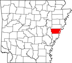
Aubrey, Arkansas | |
---|---|
Coordinates: 34°43′11″N90°53′53″W / 34.71972°N 90.89806°W | |
Country | United States |
State | Arkansas |
County | Lee |
Area | |
• Total | 0.33 sq mi (0.86 km2) |
• Land | 0.33 sq mi (0.86 km2) |
• Water | 0.00 sq mi (0.00 km2) |
Elevation | 203 ft (62 m) |
Population (2020) | |
• Total | 108 |
• Density | 325.30/sq mi (125.64/km2) |
Time zone | UTC-6 (Central (CST)) |
• Summer (DST) | UTC-5 (CDT) |
ZIP code | 72311 |
Area code | 870 |
FIPS code | 05-02680 |
GNIS feature ID | 2405183 [2] |
Aubrey is a town in Lee County, Arkansas, United States. The population was 108 at the 2020 census.
According to the United States Census Bureau, the town has a total area of 0.9 km2 (0.3 mi2), all land.
Census | Pop. | Note | %± |
---|---|---|---|
1970 | 351 | — | |
1980 | 267 | −23.9% | |
1990 | 204 | −23.6% | |
2000 | 221 | 8.3% | |
2010 | 170 | −23.1% | |
2020 | 108 | −36.5% | |
U.S. Decennial Census [3] |
As of the census [4] of 2000, there were 221 people, 92 households, and 59 families residing in the town. The population density was 251.0/km2 (641.7/mi2). There were 103 housing units at an average density of 117.0/km2 (299.1/mi2). The racial makeup of the town was 67.87% White, 30.32% Black or African American, 1.81% from other races. 4.07% of the population were Hispanic or Latino of any race.
There were 92 households, out of which 26.1% had children under the age of 18 living with them, 54.3% were married couples living together, 10.9% had a female householder with no husband present, and 34.8% were non-families. 32.6% of all households were made up of individuals, and 21.7% had someone living alone who was 65 years of age or older. The average household size was 2.40 and the average family size was 3.12.
In the town, the population was spread out, with 27.1% under the age of 18, 6.3% from 18 to 24, 18.1% from 25 to 44, 24.9% from 45 to 64, and 23.5% who were 65 years of age or older. The median age was 43 years. For every 100 females, there were 63.7 males. For every 100 females age 18 and over, there were 69.5 males.
The median income for a household in the town was $19,167, and the median income for a family was $19,167. Males had a median income of $20,250 versus $16,111 for females. The per capita income for the town was $11,805. About 15.2% of families and 18.0% of the population were below the poverty line, including 21.1% of those under the age of eighteen and 18.8% of those 65 or over.
It is in the Lee County School District, based in Marianna. [5] The local high school is Lee High School.
In 1967 the Aubrey, Brickeys, and Moro school districts all merged into the Marianna district. [6]
Big Flat is a town in Baxter and Searcy counties in the U.S. state of Arkansas. The population was 88 at the 2020 census.
Briarcliff is a second-class city in Baxter County, Arkansas, United States. The population was 236 at the 2010 census.
Everton is a town in Boone County, Arkansas, United States. The population was 133 at the 2010 census. It is part of the Harrison Micropolitan Statistical Area.
South Lead Hill is a town in Boone County, Arkansas, United States. The population was 102 at the 2010 census. It is part of the Harrison Micropolitan Statistical Area.
Valley Springs is a town in Boone County, Arkansas, United States. The population was 175 at the 2010 census. It is part of the Harrison Micropolitan Statistical Area.
Campbell Station is a city in Jackson County, Arkansas, United States. The population was 255 at the 2010 census.
Grubbs is a city in Jackson County, Arkansas, United States. The population was 386 at the 2010 census.
Haynes is a town in Lee County, Arkansas, United States. The population was 150 at the 2010 census, down from 214 at the 2000 census.
LaGrange is a town in Lee County, Arkansas, United States. The population was 89 at the 2010 census, down from 122 at the 2000 census.
Moro is a town in Lee County, Arkansas, United States. The population was 216 at the 2010 census.
Rondo is a town in Lee County, Arkansas, United States. The population was 198 at the 2010 census, down from 237 at the 2000 census.
Cale is a town in Nevada County, Arkansas, United States. The population was 75 at the 2000 census. It is part of the Hope Micropolitan Statistical Area.
Rosston is a town in south-central Nevada County, Arkansas, United States. The population was 265 at the 2000 census. It is part of the Hope Micropolitan Statistical Area.
Western Grove is a town in northeastern Newton County, Arkansas, United States. The population was 384 at the 2010 census. It is part of the Harrison Micropolitan Statistical Area.
Traskwood is a city in Saline County, Arkansas, United States. The population was 518 at the 2010 census. It is part of the Little Rock–North Little Rock–Conway Metropolitan Statistical Area.
Midland is a town in Sebastian County, Arkansas, United States. It is part of the Fort Smith, Arkansas-Oklahoma Metropolitan Statistical Area. The population was 325 at the 2010 census.
Gillham is a town in Sevier County, Arkansas, United States. The population was 188 at the 2000 census. It is located six miles from Gillham Lake.
Caldwell is a town in St. Francis County, Arkansas, United States. The population was 555 at the 2010 census, an increase from 465 in 2000.
Goshen is a city in Washington County, Arkansas, United States. The population was 2,102 at the 2020 census. It is part of the Northwest Arkansas region. According to Business Insider, it is the “most educated” city in the state of Arkansas.
Corinth is a town in Yell County, Arkansas, United States. The population was 65 at the 2000 census. It is part of the Russellville Micropolitan Statistical Area.