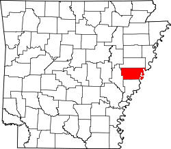
Moro, Arkansas

Last updated

Moro, Arkansas
Moro, AR 003.jpg
Moro City Park in downtown Moro
Lee County Arkansas Incorporated and Unincorporated areas Moro Highlighted 0546910.svg
Location of Moro in Lee County, Arkansas.
Coordinates: 34°47′40″N90°59′24″W / 34.79444°N 90.99000°W / 34.79444; -90.99000
Country United States
State Arkansas
County Lee
Area
[1]
  Total0.96 sq mi (2.50 km2)
  Land0.96 sq mi (2.50 km2)
  Water0.00 sq mi (0.00 km2)
Elevation
[2]
200 ft (60 m)
Population
 (2020)
  Total177
  Density183.42/sq mi (70.83/km2)
Time zone UTC-6 (Central (CST))
  Summer (DST) UTC-5 (CDT)
ZIP code
72368
Area code 870
FIPS code 05-46910
GNIS feature ID0077691 [2]

Moro is a town in Lee County, Arkansas, United States. The population was 216 at the 2010 census.

Contents

Geography

Moro is located at 34°47′40″N90°59′24″W / 34.79444°N 90.99000°W / 34.79444; -90.99000 (34.794503, -90.990119). [3]

According to the United States Census Bureau, the town has a total area of 2.5 km2 (0.9 mi2), all land.

Demographics

Historical population
CensusPop.Note
1880 51
1920 265
1930 187−29.4%
1940 27848.7%
1950 189−32.0%
1960 182−3.7%
1970 489168.7%
1980 327−33.1%
1990 287−12.2%
2000 241−16.0%
2010 216−10.4%
2020 177−18.1%
U.S. Decennial Census [4]

As of the census [5] of 2010, there were 216 people, 109 households, and 75 families residing in the town. The population density was 97.9/km2 (255.0/mi2). There were 115 housing units at an average density of 46.7/km2 (121.7/mi2). The racial makeup of the town was 98.34% White and 1.66% Black or African American.

There were 109 households, out of which 22.0% had children under the age of 18 living with them, 59.6% were married couples living together, 10.1% had a female householder with no husband present, and 30.3% were non-families. 29.4% of all households were made up of individuals, and 12.8% had someone living alone who was 65 years of age or older. The average household size was 2.21 and the average family size was 2.72.

In the town, the population was spread out, with 19.9% under the age of 18, 10.4% from 18 to 24, 22.8% from 25 to 44, 28.6% from 45 to 64, and 18.3% who were 65 years of age or older. The median age was 43 years. For every 100 females, there were 102.5 males. For every 100 females age 18 and over, there were 89.2 males.

The median income for a household in the town was $27,857, and the median income for a family was $35,625. Males had a median income of $21,667 versus $21,250 for females. The per capita income for the town was $13,264. About 12.3% of families and 16.5% of the population were below the poverty line, including 10.9% of those under the age of eighteen and 22.6% of those 65 or over.

Education

It is in the Lee County School District, based in Marianna. [6] The local high school is Lee High School.

In 1967 the Aubrey, Brickeys, and Moro school districts all merged into the Marianna district. [7]

Related Research Articles

<span class="mw-page-title-main">Lee County, Arkansas</span> County in Arkansas, United States

Lee County is a county located in the U.S. state of Arkansas. With its eastern border formed by the Mississippi River, it is considered to be part of the Arkansas Delta. As of the 2020 census, the population was 8,600. The county seat is Marianna.

<span class="mw-page-title-main">Big Flat, Arkansas</span> Town in Arkansas, United States

Big Flat is a town in Baxter and Searcy counties in the U.S. state of Arkansas. The population was 88 at the 2020 census.

<span class="mw-page-title-main">Knobel, Arkansas</span> City in Arkansas, United States

Knobel (/ˈnoʊbəl/) is a city in Clay County, Arkansas, United States. The population was 147 at the 2020 census.

<span class="mw-page-title-main">Cash, Arkansas</span> City in Arkansas, United States

Cash is a city in western Craighead County, Arkansas, United States. The population was 342 at the 2010 census. Cash Arkansas population was of mostly white with 99.8% and partial Puerto Rican ethnicity. It is included in the Jonesboro, Arkansas Metropolitan Statistical Area.

<span class="mw-page-title-main">Anthonyville, Arkansas</span> Town in Arkansas, United States

Anthonyville is a town in Crittenden County, Arkansas, United States. The population was 161 at the 2010 census, down from 250 in 2000.

<span class="mw-page-title-main">Horseshoe Lake, Arkansas</span> Town in Arkansas, United States

Horseshoe Lake is a town in Crittenden County, Arkansas, United States. The population was 264 at the 2020 census.

<span class="mw-page-title-main">Oil Trough, Arkansas</span> Town in Arkansas, United States

Oil Trough is a town in Independence County, Arkansas, United States. The population was 260 at the 2010 census. The town is believed to have acquired its name in the early 19th century from a trough used to render bear fat, which was sold to customers in New Orleans.

<span class="mw-page-title-main">Aubrey, Arkansas</span> Town in Arkansas, United States

Aubrey is a town in Lee County, Arkansas, United States. The population was 108 at the 2020 census.

<span class="mw-page-title-main">Haynes, Arkansas</span> Town in Arkansas, United States

Haynes is a town in Lee County, Arkansas, United States. The population was 150 at the 2010 census, down from 214 at the 2000 census.

<span class="mw-page-title-main">LaGrange, Arkansas</span> Town in Arkansas, United States

LaGrange is a town in Lee County, Arkansas, United States. The population was 89 at the 2010 census, down from 122 at the 2000 census.

<span class="mw-page-title-main">Marianna, Arkansas</span> Town in Arkansas, United States

Marianna is a town in and the county seat of Lee County, Arkansas, United States. As of the 2010 census it had a population of 4,115, but by 2018 the population had dropped to an estimated 3,477.

<span class="mw-page-title-main">Rondo, Arkansas</span> Town in Arkansas, United States

Rondo is a town in Lee County, Arkansas, United States. The population was 198 at the 2010 census, down from 237 at the 2000 census.

<span class="mw-page-title-main">Hatfield, Arkansas</span> Town in Arkansas, United States

Hatfield is a town in western Polk County, Arkansas, United States. The population was 413 at the 2010 census.

<span class="mw-page-title-main">Ulm, Arkansas</span> Town in Arkansas, United States

Ulm is a town in Prairie County, Arkansas, United States. The population was 205 at the 2000 census.

<span class="mw-page-title-main">O'Kean, Arkansas</span> Town in Arkansas, United States

O'Kean is a town in Randolph County, Arkansas, United States. The population was 192 at the 2020 census.

<span class="mw-page-title-main">Traskwood, Arkansas</span> City in Arkansas, United States

Traskwood is a city in Saline County, Arkansas, United States. The population was 518 at the 2010 census. It is part of the Little Rock–North Little Rock–Conway Metropolitan Statistical Area.

<span class="mw-page-title-main">Gillham, Arkansas</span> Town in Arkansas, United States

Gillham is a town in Sevier County, Arkansas, United States. The population was 188 at the 2000 census. It is located six miles from Gillham Lake.

<span class="mw-page-title-main">Caldwell, Arkansas</span> Town in Arkansas, United States

Caldwell is a town in St. Francis County, Arkansas, United States. The population was 555 at the 2010 census, an increase from 465 in 2000.

<span class="mw-page-title-main">Widener, Arkansas</span> Town in Arkansas, United States

Widener is a town in St. Francis County, Arkansas, United States. The population was 212 at the 2020 census, a decline from 273 in 2010.

<span class="mw-page-title-main">Bridgewater (CDP), Massachusetts</span> Census-designated place in Massachusetts, United States

Bridgewater was a census-designated place (CDP) in the town of Bridgewater in Plymouth County, Massachusetts, United States. The CDP ceased to exist when Bridgewater was given de facto city status in 2010. The population was 7,841 at the 2010 census.

References

  1. "2020 U.S. Gazetteer Files". United States Census Bureau. Retrieved October 29, 2021.
  2. 1 2 U.S. Geological Survey Geographic Names Information System: Moro, Arkansas
  3. "US Gazetteer files: 2010, 2000, and 1990". United States Census Bureau. February 12, 2011. Retrieved April 23, 2011.
  4. "Census of Population and Housing". Census.gov. Retrieved June 4, 2015.
  5. "U.S. Census website". United States Census Bureau . Retrieved January 31, 2008.
  6. "SCHOOL DISTRICT REFERENCE MAP (2010 CENSUS): Lee County, AR" (PDF). U.S. Census Bureau . Retrieved February 27, 2021.
  7. Goatcher, Truett (January 1999). "School District Consolidation Will Save Millions of Dollars: Fact of Myth?" (PDF). Arkansas Association of Educational Administrators. p. 12 (PDF p. 15/27).