Roe, Arkansas

Last updated

Roe, Arkansas
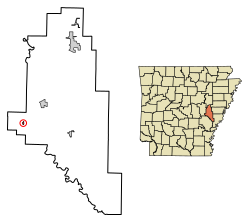
Monroe County Arkansas Incorporated and Unincorporated areas Roe Highlighted 0560380.svg
Location in Monroe County, Arkansas
Coordinates: 34°37′52″N91°23′09″W / 34.63111°N 91.38583°W / 34.63111; -91.38583
Country United States
State Arkansas
County Monroe
Area
[1]
  Total0.18 sq mi (0.46 km2)
  Land0.18 sq mi (0.46 km2)
  Water0.00 sq mi (0.00 km2)
Elevation
[2]
213 ft (65 m)
Population
 (2020) [3]
  Total68
  Density379.89/sq mi (146.91/km2)
Time zone UTC-6 (Central (CST))
  Summer (DST) UTC-5 (CDT)
ZIP code
72134
Area code 870
FIPS code 05-60380
GNIS feature ID2407234 [2]

Roe is a town in Monroe County, Arkansas, United States. Located at the junction of U.S. Route 79 and Arkansas Highway 33, the population was 68 at the 2020 census, [3] down from 114 in 2010.

Contents

History

Roe began as a railroad depot around 1880 on the Cotton Belt (officially the St. Louis Southwestern Railway). [4] Originally located in Prairie County, a boundary adjustment in 1883 placed it in Monroe County. [4] The small community saw new growth when U.S. Route 79 was constructed through the town in 1935. Roe was incorporated as a town in 1968. [4]

Geography

Roe is located in western Monroe County. Via U.S. Route 79, it is 14 miles (23 km) northeast of Stuttgart and 7 miles (11 km) southwest of Clarendon, the Monroe county seat.

According to the United States Census Bureau, the town has a total area of 0.18 square miles (0.47 km2), all land. [1] Roe is in the small portion of Monroe County that is west of the White River, and it is situated along the northern edge of the Grand Prairie in the Arkansas Delta.

Climate

The climate in this area is characterized by hot, humid summers and generally mild to cool winters. According to the Köppen Climate Classification system, Roe has a humid subtropical climate, abbreviated "Cfa" on climate maps. [5]

Demographics

Historical population
CensusPop.Note
1970 127
1980 1367.1%
1990 135−0.7%
2000 124−8.1%
2010 114−8.1%
2020 68−40.4%
U.S. Decennial Census [6]

As of the census [7] of 2000, there were 124 people, 50 households, and 36 families residing in the town. The population density was 252.0/km2 (636.5/mi2). There were 56 housing units at an average density of 113.8/km2 (287.5/mi2). The racial makeup of the town was 91.94% White, 7.26% Black or African American, and 0.81% from two or more races.

There were 50 households, out of which 34.0% had children under the age of 18 living with them, 60.0% were married couples living together, 6.0% had a female householder with no husband present, and 28.0% were non-families. 24.0% of all households were made up of individuals, and 10.0% had someone living alone who was 65 years of age or older. The average household size was 2.48 and the average family size was 2.92.

In the town, the population was spread out, with 25.8% under the age of 18, 3.2% from 18 to 24, 30.6% from 25 to 44, 26.6% from 45 to 64, and 13.7% who were 65 years of age or older. The median age was 39 years. For every 100 females, there were 106.7 males. For every 100 females age 18 and over, there were 114.0 males.

The median income for a household in the town was $38,750, and the median income for a family was $50,000. Males had a median income of $31,500 versus $33,125 for females. The per capita income for the town was $23,028. There were 6.7% of families and 9.0% of the population living below the poverty line, including 12.1% of under eighteens and 20.0% of those over 64.

Related Research Articles

<span class="mw-page-title-main">Almyra, Arkansas</span> Town in Arkansas, United States

Almyra is a town in Arkansas County, Arkansas, United States. The population was 283 at the 2010 census.

<span class="mw-page-title-main">Alpena, Arkansas</span> Town in Arkansas, United States

Alpena is a town in Boone and Carroll counties in the U.S. state of Arkansas. The population was 374 at the 2020 census.

<span class="mw-page-title-main">Diamond City, Arkansas</span> City in Arkansas, United States

Diamond City is a city in northeast Boone County, Arkansas, United States. The population was 782 at the 2010 census. It is part of the Harrison Micropolitan Statistical Area.

<span class="mw-page-title-main">Thornton, Arkansas</span> City in Arkansas, United States

Thornton is a city in Calhoun County, Arkansas, United States. The population was 407 as of the 2010 census, down from 517 in 2000. It is part of the Camden, Arkansas micropolitan area.

<span class="mw-page-title-main">Beedeville, Arkansas</span> Town in Arkansas, United States

Beedeville is a town in Jackson County, Arkansas, United States. The population was 107 at the 2010 census.

<span class="mw-page-title-main">Alicia, Arkansas</span> Town in Arkansas, United States

Alicia is a town in Lawrence County, Arkansas, United States. The population was 124 at the 2010 census.

<span class="mw-page-title-main">College City, Arkansas</span> Former town in Arkansas, United States

College City is a former town in Lawrence County, Arkansas, United States. The population was 455 at the 2010 census. It is the site of Williams Baptist College, a four-year liberal arts college. The town merged with nearby Walnut Ridge effective January 1, 2017.

<span class="mw-page-title-main">Clarendon, Arkansas</span> City in Arkansas, United States

Clarendon is a city in, and the county seat of, Monroe County, Arkansas, United States. Located in the Arkansas Delta, the city's position on the White River at the mouth of the Cache River has defined the community since first incorporating in 1859. Although the river has brought devastation and disaster to the city occasionally throughout history, it has also provided economic opportunities, transportation, recreation and tourism to the city.

<span class="mw-page-title-main">Rosston, Arkansas</span> Town in Arkansas, United States

Rosston is a town in south-central Nevada County, Arkansas, United States. The population was 265 at the 2000 census. It is part of the Hope Micropolitan Statistical Area.

<span class="mw-page-title-main">Perry, Arkansas</span> Town in Arkansas, United States

Perry is a town in Perry County, Arkansas, United States. The population was 314 at the 2000 census. It is part of the Little Rock–North Little Rock–Conway Metropolitan Statistical Area.

<span class="mw-page-title-main">Hatfield, Arkansas</span> Town in Arkansas, United States

Hatfield is a town in western Polk County, Arkansas, United States. The population was 413 at the 2010 census.

<span class="mw-page-title-main">Hector, Arkansas</span> Town in Arkansas, United States

Hector is a town in Pope County, Arkansas, United States. The population was 450 at the 2010 census. It is part of the Russellville Micropolitan Statistical Area.

<span class="mw-page-title-main">DeValls Bluff, Arkansas</span> City in Arkansas, United States

DeValls Bluff is a city in and the county seat of the southern district of Prairie County, Arkansas, United States. The population was 619 at the 2010 census.

<span class="mw-page-title-main">Hazen, Arkansas</span> City in Arkansas, United States

Hazen is a city in Prairie County, Arkansas, United States. The population was 1,481 at the 2020 census.

<span class="mw-page-title-main">Ulm, Arkansas</span> Town in Arkansas, United States

Ulm is a town in Prairie County, Arkansas, United States. The population was 205 at the 2000 census.

<span class="mw-page-title-main">Gilbert, Arkansas</span> Town in Arkansas, United States

Gilbert is a town in Searcy County, Arkansas, United States. The population was 26 at the 2020 census, ranking it as the smallest municipality in the state and one of the smallest in the nation. Over the years, Gilbert has gained a reputation as one of the coldest locations in Arkansas.

<span class="mw-page-title-main">Georgetown, Arkansas</span> Town in Arkansas, United States

Georgetown is a town in southeastern White County, Arkansas, United States, overlooking the White River. First settled in 1789 before the Louisiana Purchase, the community is the oldest continuously settled area in Arkansas.

<span class="mw-page-title-main">Yankeetown, Florida</span> Town in the state of Florida, United States

Yankeetown is a town in Levy County, Florida, United States. Its located in North Florida along the Gulf of Mexico. The Town of Yankeetown is part of both the Big Bend Coast and the Nature Coast. In the 2020 census, the population was 588.

<span class="mw-page-title-main">Marion Center, Massachusetts</span> Census-designated place in Massachusetts, United States

Marion Center is a census-designated place (CDP) in the town of Marion in Plymouth County, Massachusetts, United States. The population was 1,111 at the 2010 census.

<span class="mw-page-title-main">Manchester Center, Vermont</span> Census-designated place in Vermont, United States

Manchester Center is a census-designated place (CDP) in the town of Manchester in Bennington County, Vermont, United States. As of the 2010 census, the CDP had a population of 2,120, out of 4,391 people in the entire town of Manchester.

References

  1. 1 2 "2021 U.S. Gazetteer Files: Arkansas". United States Census Bureau. Retrieved June 23, 2022.
  2. 1 2 U.S. Geological Survey Geographic Names Information System: Roe, Arkansas
  3. 1 2 "P1. Race – Roe town, Arkansas: 2020 DEC Redistricting Data (PL 94-171)". U.S. Census Bureau. Retrieved June 23, 2022.
  4. 1 2 3 Teske, Steven. "Roe (Monroe County)". Encyclopedia of Arkansas. Retrieved July 9, 2019.
  5. Climate Summary for Roe, Arkansas
  6. "Census of Population and Housing". Census.gov. Retrieved June 4, 2015.
  7. "U.S. Census website". United States Census Bureau . Retrieved January 31, 2008.