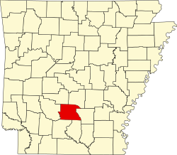
Dallas County | |
---|---|
Coordinates: 33°58′37″N92°40′23″W / 33.976944444444°N 92.673055555556°W | |
Country | United States |
State | Arkansas |
Founded | January 1, 1845 |
Named for | George M. Dallas |
Seat | Fordyce |
Largest city | Fordyce |
Area | |
• Total | 668 sq mi (1,730 km2) |
• Land | 667 sq mi (1,730 km2) |
• Water | 0.7 sq mi (2 km2) 0.1% |
Population (2020) | |
• Total | 6,482 |
• Density | 9.7/sq mi (3.7/km2) |
Time zone | UTC−6 (Central) |
• Summer (DST) | UTC−5 (CDT) |
Congressional district | 4th |
Dallas County is a county located in the U.S. state of Arkansas. As of the 2020 census, the population was 6,482, [1] making it the fourth-least populous county in Arkansas. The county seat is Fordyce. [2] Dallas County is Arkansas's 49th county, formed on January 1, 1845; it was named for George M. Dallas, 11th Vice President of the United States.
According to the U.S. Census Bureau, the county has a total area of 668 square miles (1,730 km2), of which 667 square miles (1,730 km2) is land and 0.7 square miles (1.8 km2) (0.1%) is water. [3]
Census | Pop. | Note | %± |
---|---|---|---|
1850 | 6,877 | — | |
1860 | 8,283 | 20.4% | |
1870 | 5,707 | −31.1% | |
1880 | 6,505 | 14.0% | |
1890 | 9,296 | 42.9% | |
1900 | 11,518 | 23.9% | |
1910 | 12,621 | 9.6% | |
1920 | 14,424 | 14.3% | |
1930 | 14,671 | 1.7% | |
1940 | 14,471 | −1.4% | |
1950 | 12,416 | −14.2% | |
1960 | 10,522 | −15.3% | |
1970 | 10,022 | −4.8% | |
1980 | 10,515 | 4.9% | |
1990 | 9,614 | −8.6% | |
2000 | 9,210 | −4.2% | |
2010 | 8,116 | −11.9% | |
2020 | 6,482 | −20.1% | |
2023 (est.) | 6,185 | [4] | −4.6% |
U.S. Decennial Census [5] 1790–1960 [6] 1900–1990 [7] 1990–2000 [8] 2010 [9] |
Race | Num. | Perc. |
---|---|---|
White (non-Hispanic) | 3,425 | 52.84% |
Black or African American (non-Hispanic) | 2,582 | 39.83% |
Native American | 14 | 0.22% |
Asian | 7 | 0.11% |
Other/Mixed | 253 | 3.9% |
Hispanic or Latino | 201 | 3.1% |
As of the 2020 United States census, there were 6,482 people, 2,969 households, and 1,797 families residing in the county.
As of the 2000 census, [12] there were 9,210 people, 3,519 households, and 2,431 families residing in the county. The population density was 14 people per square mile (5.4 people/km2). There were 4,401 housing units at an average density of 7 units per square mile (2.7 units/km2). The racial makeup of the county was 56.96% White, 40.98% Black or African American, 0.24% Native American, 0.23% Asian, 1.01% from other races, and 0.59% from two or more races. 1.92% of the population were Hispanic or Latino of any race.
There were 3,519 households, out of which 29.60% had children under the age of 18 living with them, 51.00% were married couples living together, 13.80% had a female householder with no husband present, and 30.90% were non-families. 28.30% of all households were made up of individuals, and 13.90% had someone living alone who was 65 years of age or older. The average household size was 2.48 and the average family size was 3.03.
In the county, the population was spread out, with 26.20% under the age of 18, 8.30% from 18 to 24, 24.50% from 25 to 44, 24.10% from 45 to 64, and 17.00% who were 65 years of age or older. The median age was 38 years. For every 100 females there were 94.30 males. For every 100 females age 18 and over, there were 91.90 males.
The median income for a household in the county was $26,608, and the median income for a family was $32,630. Males had a median income of $28,538 versus $17,884 for females. The per capita income for the county was $14,610. About 13.30% of families and 18.90% of the population were below the poverty line, including 23.80% of those under age 18 and 20.00% of those age 65 or over.
Prior to 2004, this county was considered an "ancestral" Democratic county, where Democrats won every presidential race with exceptions for the 1968 campaign of George Wallace and the 1972 and 1984 landslides of Richard Nixon and Ronald Reagan, respectively. Former Governor Bill Clinton won this county twice in his presidential runs: 1992 and 1996. Al Gore won this county in 2000, the most recent Democrat to do so.
Year | Republican | Democratic | Third party(ies) | |||
---|---|---|---|---|---|---|
No. | % | No. | % | No. | % | |
2024 | 1,482 | 63.77% | 798 | 34.34% | 44 | 1.89% |
2020 | 1,573 | 59.38% | 963 | 36.35% | 113 | 4.27% |
2016 | 1,509 | 54.46% | 1,165 | 42.04% | 97 | 3.50% |
2012 | 1,665 | 53.99% | 1,337 | 43.35% | 82 | 2.66% |
2008 | 1,757 | 52.95% | 1,471 | 44.33% | 90 | 2.71% |
2004 | 1,700 | 50.18% | 1,671 | 49.32% | 17 | 0.50% |
2000 | 1,571 | 47.25% | 1,710 | 51.43% | 44 | 1.32% |
1996 | 1,041 | 30.31% | 2,118 | 61.66% | 276 | 8.03% |
1992 | 1,458 | 37.15% | 2,107 | 53.68% | 360 | 9.17% |
1988 | 1,947 | 49.19% | 1,990 | 50.28% | 21 | 0.53% |
1984 | 2,361 | 52.80% | 2,035 | 45.51% | 76 | 1.70% |
1980 | 1,596 | 35.16% | 2,838 | 62.52% | 105 | 2.31% |
1976 | 1,012 | 23.61% | 3,266 | 76.20% | 8 | 0.19% |
1972 | 2,152 | 60.55% | 1,402 | 39.45% | 0 | 0.00% |
1968 | 672 | 18.43% | 1,253 | 34.36% | 1,722 | 47.22% |
1964 | 1,625 | 47.14% | 1,779 | 51.61% | 43 | 1.25% |
1960 | 659 | 25.20% | 1,639 | 62.68% | 317 | 12.12% |
1956 | 984 | 35.63% | 1,726 | 62.49% | 52 | 1.88% |
1952 | 737 | 25.03% | 2,202 | 74.80% | 5 | 0.17% |
1948 | 152 | 8.93% | 1,174 | 68.98% | 376 | 22.09% |
1944 | 266 | 17.65% | 1,238 | 82.15% | 3 | 0.20% |
1940 | 118 | 8.04% | 1,295 | 88.28% | 54 | 3.68% |
1936 | 103 | 6.71% | 1,433 | 93.29% | 0 | 0.00% |
1932 | 150 | 6.53% | 2,139 | 93.16% | 7 | 0.30% |
1928 | 503 | 32.73% | 1,030 | 67.01% | 4 | 0.26% |
1924 | 401 | 26.68% | 1,068 | 71.06% | 34 | 2.26% |
1920 | 659 | 36.19% | 1,140 | 62.60% | 22 | 1.21% |
1916 | 527 | 31.43% | 1,150 | 68.57% | 0 | 0.00% |
1912 | 228 | 17.33% | 654 | 49.70% | 434 | 32.98% |
1908 | 636 | 44.26% | 721 | 50.17% | 80 | 5.57% |
1904 | 496 | 43.06% | 604 | 52.43% | 52 | 4.51% |
1900 | 514 | 40.35% | 746 | 58.56% | 14 | 1.10% |
1896 | 479 | 31.55% | 1,032 | 67.98% | 7 | 0.46% |
Townships in Arkansas are the divisions of a county. Each township includes unincorporated areas; some may have incorporated cities or towns within part of their boundaries. Arkansas townships have limited purposes in modern times. However, the United States census does list Arkansas population based on townships (sometimes referred to as "county subdivisions" or "minor civil divisions"). Townships are also of value for historical purposes in terms of genealogical research. Each town or city is within one or more townships in an Arkansas county based on census maps and publications. The townships of Dallas County are listed below; listed in parentheses are the cities, towns, and/or census-designated places that are fully or partially inside the township. [14] [15]
Sharp County is a county located in the U.S. state of Arkansas. As of the 2020 census, the population was 17,271. The county seat is Ash Flat. The county was formed on July 18, 1868, and named for Ephraim Sharp, a state legislator from the area.
Pulaski County is a county in the U.S. state of Arkansas. With a population of 399,125 as of the 2020 United States Census, it is the most populous county in Arkansas. The county is included in the Little Rock–North Little Rock–Conway metropolitan area. Its county seat is Little Rock, which is also Arkansas's capital and largest city.
Polk County is a county located in the U.S. state of Arkansas. As of the 2020 census, the population was 19,221. The county seat is Mena. Polk County is Arkansas's 48th county, formed on November 30, 1844; it was named for James K. Polk, 11th President of the United States.
Ouachita County is a county located in the south central part of the U.S. state of Arkansas. As of the 2020 census, the population was 22,650.
Nevada County is a county located in the southwestern part of the U.S. state of Arkansas. As of the 2020 Census, the population was 8,310, less than half of its peak in 1920. The county seat is Prescott. Nevada County is Arkansas's 63rd county, formed during the Reconstruction era on March 20, 1871, from portions of Hempstead, Ouachita and Columbia counties. It was named after the state of Nevada because of the perceived similarity between their physical shapes; the Arkansas county's shape, inverted, roughly follows the same outline as the state's boundary. It is an alcohol prohibition or dry county.
Izard County is a county located in the U.S. state of Arkansas. As of the 2020 census, the population was 13,577. The county seat is Melbourne. Izard County is Arkansas's 13th county, formed on October 27, 1825, and named for War of 1812 General and Arkansas Territorial Governor George Izard. It is an alcohol prohibition or dry county.
Howard County is a county located in the U.S. state of Arkansas. As of the 2020 census, the population was 12,785. The county seat is Nashville. Howard County is Arkansas's 74th county, formed on April 17, 1873, and named for James Howard, a state senator. It is a dry county.
Hempstead County is a county located in the U.S. state of Arkansas. As of the 2020 census, the population was 20,065, down from 22,609 at the 2010 census. The county seat is Hope. Hempstead County is Arkansas's fourth county, formed on December 15, 1818, alongside Clark and Pulaski counties. The county is named for Edward Hempstead, a delegate to the U.S. Congress from the Missouri Territory, which included present-day Arkansas at the time. It is an alcohol prohibition or dry county.
Fulton County is a county located in the U.S. state of Arkansas. As of the 2020 census, the population was 12,075. The county seat is Salem. Fulton County was formed on December 21, 1842, and named for William Fulton, the last governor of the Arkansas Territory. It is an alcohol prohibition or dry county.
Faulkner County is a county located in the Central Arkansas region of the U.S. state of Arkansas. As of the 2020 census, the population was 123,498, making it the fifth most populous of Arkansas's 75 counties. The county seat and largest city is Conway. Faulkner County was created on April 12, 1873, one of nine counties formed during Reconstruction, and is named for Sandford C. Faulkner, better known as Sandy Faulkner, a popular figure in the state at the time.
Drew County is a county located in the southeast region of the U.S. state of Arkansas. As of the 2020 census, the population was 17,350. The county seat and largest city is Monticello. Drew County was formed on November 26, 1846, and named for Thomas Drew, the third governor of Arkansas.
Cleveland County is a county located in the U.S. state of Arkansas. Its population was 7,550 at the 2020 U.S. census. The county seat and largest city is Rison. Cleveland County is included in the Pine Bluff, AR Metropolitan Statistical Area, which is also included in the Little Rock-North Little Rock, AR Combined Statistical Area.
Cleburne County is a county located in the U.S. state of Arkansas. As of the 2020 census, the population was 24,711. The county seat and most populous city is Heber Springs. The county was formed on February 20, 1883, as the last of Arkansas's 75 counties to be formed. It is named for Confederate Major-General Patrick Cleburne. Cleburne is an alcohol prohibition or dry county.
Chicot County is a county located in the southeastern corner of the U.S. state of Arkansas. As of the 2020 census, the population was 10,208. The county seat is Lake Village. Chicot County is Arkansas's 10th county, formed on October 25, 1823, and named after Point Chicot on the Mississippi River. It is part of the Arkansas Delta, lowlands along the river that have been historically important as an area for large-scale cotton cultivation.
Carroll County is a county located in the U.S. state of Arkansas. As of the 2020 census, the population was 28,260. The county has two county seats, Berryville and Eureka Springs. Carroll County is Arkansas's 26th county, formed on November 1, 1833, and named after Charles Carroll, the last surviving signer of the United States Declaration of Independence.
Hampton is a town in Calhoun County, Arkansas, United States. The population was 1,181 according to the 2020 United States Census. The town is the county seat of Calhoun County.
Fordyce is a city in southeast Dallas County, Arkansas, United States. Its population has been decreasing since the 1980s when the town reached an all time high of 5,175. The population in 2020 was 3,396 down from 4,300 at the 2010 census, and from 4,799 in 2000.
Sparkman is a city in Dallas County, Arkansas, United States. The population was 355 at the 2020 census, down from 427 in 2010.
Maine Prairie Township is a township in Stearns County, Minnesota, United States. The population was 1,887 at the 2010 census.
Shenango Township is a township in Mercer County, Pennsylvania, United States. The population was 3,519 at the 2020 census, down from 3,929 in 2010.