Carthage, Arkansas

Last updated

Carthage, Arkansas
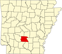
Dallas County Arkansas Incorporated and Unincorporated areas Carthage Highlighted 0511830.svg
Location of Carthage in Dallas County, Arkansas.
Coordinates: 34°04′21″N92°33′19″W / 34.07250°N 92.55528°W / 34.07250; -92.55528
Country United States
State Arkansas
County Dallas
Area
[1]
  Total0.99 sq mi (2.56 km2)
  Land0.99 sq mi (2.56 km2)
  Water0.00 sq mi (0.00 km2)
Elevation
[2]
308 ft (94 m)
Population
 (2020)
  Total222
  Density224.47/sq mi (86.68/km2)
Time zone UTC-6 (Central (CST))
  Summer (DST) UTC-5 (CDT)
ZIP code
71725
Area code 870
FIPS code 05-11830
GNIS feature ID2404003 [2]

Carthage is a town [3] in Dallas County, Arkansas, United States. The population was 343 at the 2010 census.

Contents

Geography

According to the United States Census Bureau, the city has a total area of 1.0 square mile (2.6 km2), all land.

Demographics

Historical population
CensusPop.Note
1910 386
1920 53237.8%
1930 5584.9%
1940 68723.1%
1950 533−22.4%
1960 528−0.9%
1970 5667.2%
1980 5680.4%
1990 452−20.4%
2000 442−2.2%
2010 343−22.4%
2020 222−35.3%
U.S. Decennial Census [4]
2014 Estimate [5]

2020 census

Carthage, Arkansas – Racial and ethnic composition
(NH = Non-Hispanic)
Note: the US Census treats Hispanic/Latino as an ethnic category. This table excludes Latinos from the racial categories and assigns them to a separate category. Hispanics/Latinos may be of any race.
Race / EthnicityPop 2000 [6] Pop 2010 [7] Pop 2020 [8] % 2000% 2010% 2020
White alone (NH)63513014.25%14.87%13.51%
Black or African American alone (NH)36327217982.13%79.30%80.63%
Native American or Alaska Native alone (NH)0200.00%0.58%0.00%
Asian alone (NH)0010.00%0.00%0.45%
Pacific Islander alone (NH)0000.00%0.00%0.00%
Some Other Race alone (NH)0010.00%0.00%0.45%
Mixed Race/Multi-Racial (NH)1970.23%2.62%3.15%
Hispanic or Latino (any race)15943.39%2.62%1.80%
Total442343222100.00%100.00%100.00%

As of the 2010 United States Census, there were 343 people living in the city. The racial makeup of the city was 79.3% Black, 14.9% White, 0.6% Native American and 2.6% from two or more races. 2.6% were Hispanic or Latino of any race.

As of the census [9] of 2000, there were 442 people, 159 households, and 94 families living in the city. The population density was 439.8 inhabitants per square mile (169.8/km2). There were 193 housing units at an average density of 192.1 per square mile (74.2/km2). The racial makeup of the city was 16.29% White, 82.8% Black or African American, 0.68% from other races, and 0.23% from two or more races. 3.39% of the population were Hispanic or Latino of any race.

There were 159 households, out of which 29.6% had children under the age of 18 living with them, 35.2% were married couples living together, 19.5% had a female householder with no husband present, and 40.3% were non-families. 39.0% of all households were made up of individuals, and 21.4% had someone living alone who was 65 years of age or older. The average household size was 2.45 and the average family size was 3.20.

In the city the population was spread out, with 25.6% under the age of 18, 7.5% from 18 to 24, 22.6% from 25 to 44, 20.8% from 45 to 64, and 23.5% who were 65 years of age or older. The median age was 40 years. For every 100 females, there were 110.5 males. For every 100 females age 18 and over, there were 98.2 males.

The median income for a household in the city was $23,750, and the median income for a family was $33,750. Males had a median income of $22,188 versus $18,229 for females. The per capita income for the city was $11,466. About 19.3% of families and 24.0% of the population were below the poverty line, including 29.2% of those under age 18 and 33.3% of those age 65 or over.

Transportation

Carthage is traversed by two Arkansas state highways, 48 to the east and 229 to the south.

Education

It is served by the Malvern School District. [10] Zoned schools include Malvern Elementary School, Wilson Intermediate School, Malvern Middle School, and Malvern High School.

On July 1, 2004, the Carthage School District consolidated into the Malvern School District. [11]

Related Research Articles

<span class="mw-page-title-main">Panola County, Texas</span> County in Texas, United States

Panola County is a county located in the U.S. state of Texas. As of the 2020 census, its population was 22,491. The county seat is Carthage. Located in East Texas and originally developed for cotton plantations, the county's name is derived from a Choctaw word for cotton.

<span class="mw-page-title-main">North Crossett, Arkansas</span> CDP in Arkansas, United States

North Crossett is a census-designated place (CDP) in Ashley County, Arkansas, United States. Per the 2020 census, the population was 2,756.

<span class="mw-page-title-main">West Crossett, Arkansas</span> CDP in Arkansas, United States

West Crossett is a census-designated place (CDP) in Ashley County, Arkansas, United States. Per the 2020 census, the population was 1,144.

<span class="mw-page-title-main">Prairie Creek, Arkansas</span> CDP in Arkansas, United States

Prairie Creek is a census-designated place (CDP) in Benton County, Arkansas, United States. Per the 2020 census, the population was 2,217. It is a lakefront community adjacent to Beaver Lake and Rogers within the Northwest Arkansas region.

<span class="mw-page-title-main">Harrell, Arkansas</span> Town in Arkansas, United States

Harrell is a town in Calhoun County, Arkansas, United States. The population was 254 at the 2010 census. It is part of the Camden Micropolitan Statistical Area.

<span class="mw-page-title-main">Anthonyville, Arkansas</span> Town in Arkansas, United States

Anthonyville is a town in Crittenden County, Arkansas, United States. The population was 161 at the 2010 census, down from 250 in 2000.

<span class="mw-page-title-main">Edmondson, Arkansas</span> Town in Arkansas, United States

Edmondson is a town in Crittenden County, Arkansas, United States. The population was 427 at the 2010 census.

<span class="mw-page-title-main">Gilmore, Arkansas</span> City in Arkansas, United States

Gilmore is a city in Crittenden County, Arkansas, United States. Per the 2020 census, the population was 176.

<span class="mw-page-title-main">Turrell, Arkansas</span> City in Arkansas, United States

Turrell is a city in Crittenden County, Arkansas, United States. Per the 2020 census, the population was 517.

<span class="mw-page-title-main">Bradley, Arkansas</span> City in Arkansas, United States

Bradley is a city in Lafayette County, Arkansas, United States. The population was 628 at the 2010 census.

<span class="mw-page-title-main">Bluff City, Arkansas</span> Town in Arkansas, United States

Bluff City is an unincorporated town in Nevada County, Arkansas, United States. The population was 158 at the 2000 census. It is part of the Hope Micropolitan Statistical Area.

<span class="mw-page-title-main">Fredonia (Biscoe), Arkansas</span> City in Arkansas, United States

Fredonia (Biscoe) is a city in Prairie County, Arkansas, United States. The population was 363 at the 2010 census.

<span class="mw-page-title-main">Landmark, Arkansas</span> CDP in Arkansas, United States

Landmark is a census-designated place (CDP) in Pulaski County, Arkansas, United States. Per the 2020 census, the population was 3,585. It is part of the Little Rock–North Little Rock–Conway Metropolitan Statistical Area.

<span class="mw-page-title-main">Salem, Saline County, Arkansas</span> CDP in Arkansas, United States

Salem is a census-designated place (CDP) in Saline County, Arkansas, United States. Per the 2020 census, the population was 2,544. It is part of the Little Rock–North Little Rock–Conway Metropolitan Statistical Area.

<span class="mw-page-title-main">Hughes, Arkansas</span> Town in Arkansas, United States

Hughes is a city in St. Francis County, Arkansas, United States. As of the 2020 census, it had a population of 1,056.

<span class="mw-page-title-main">Bonita, Louisiana</span> Village in Louisiana, United States

Bonita is a village in Morehouse Parish, Louisiana, United States. The population was 170 at the 2020 census, down from 284 in 2010.

<span class="mw-page-title-main">Bel-Ridge, Missouri</span> City in Missouri, United States

Bel-Ridge is a suburban city in northern St. Louis County, Missouri, United States. The population was 2,737 at the 2010 census. Bel-Ridge is part of the Normandy Schools Collaborative. Bel-Ridge became a city in 2015 by a vote of the voters.

<span class="mw-page-title-main">Bellerive Acres, Missouri</span> City in Missouri, United States

Bellerive Acres is a northern suburban city in St. Louis County, Missouri, United States. The population was 188 at the 2010 census. In April, 2015, the residents voted to change the village of Bellerive to a fourth class city named Bellerive Acres.

<span class="mw-page-title-main">Ansonville, North Carolina</span> Town in North Carolina, United States

Ansonville is a town in Anson County, North Carolina, United States. The population was 440 at the 2020 census. The town has a total area of 1.5 square miles (3.8 km2), all land. It is located on the northern edge of Anson County, about a mile west of the Pee Dee River.

<span class="mw-page-title-main">Urbancrest, Ohio</span> Village in Ohio, United States

Urbancrest is a village in Franklin County, Ohio, United States. The population was 1,031 at the 2020 census. Urbancrest is in the South-Western City Schools District.

References

  1. "2020 U.S. Gazetteer Files". United States Census Bureau. Retrieved October 29, 2021.
  2. 1 2 U.S. Geological Survey Geographic Names Information System: Carthage, Arkansas
  3. Local.Arkansas.gov - Carthage , retrieved September 3, 2012
  4. "Census of Population and Housing". Census.gov. Retrieved June 4, 2015.
  5. "Annual Estimates of the Resident Population for Incorporated Places: April 1, 2010 to July 1, 2014". Archived from the original on May 22, 2015. Retrieved June 4, 2015.
  6. "P004: Hispanic or Latino, and Not Hispanic or Latino by Race – 2000: DEC Summary File 1 – Carthage city, Arkansas". United States Census Bureau.
  7. "P2 Hispanic or Latino, and Not Hispanic or Latino by Race – 2010: DEC Redistricting Data (PL 94-171) – Carthage city, Arkansas". United States Census Bureau .
  8. "P2 Hispanic or Latino, and Not Hispanic or Latino by Race – 2020: DEC Redistricting Data (PL 94-171) – Carthage city, Arkansas". United States Census Bureau .
  9. "U.S. Census website". United States Census Bureau . Retrieved January 31, 2008.
  10. "2020 CENSUS - SCHOOL DISTRICT REFERENCE MAP: Dallas County, AR" (PDF). U.S. Census Bureau . Retrieved September 17, 2022. - 2010 map
  11. "ConsolidationAnnex_from_1983.xls Archived 2015-09-12 at the Wayback Machine ." Arkansas Department of Education. Retrieved on April 25, 2018.