Ouachita | |
---|---|
Coordinates: 33°51′08″N92°49′46″W / 33.85222°N 92.82944°W | |
Country | United States |
State | Arkansas |
County | Dallas |
Elevation | 154 ft (47 m) |
Time zone | UTC-6 (Central (CST)) |
• Summer (DST) | UTC-5 (CDT) |
Area code | 870 |
GNIS feature ID | 77932 [1] |
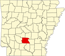
Ouachita (also Washita) is an unincorporated community in Dallas County, Arkansas, United States. [1] [2]
Ouachita County is a county located in the south central part of the U.S. state of Arkansas. As of the 2020 census, the population was 22,650.
Hot Spring County is located in the U.S. state of Arkansas. As of the 2020 census, the population was 33,040. The county seat is Malvern. Established on November 2, 1829, in the Arkansas Territory from a part of Clark County; it was named after the hot springs at Hot Springs, Arkansas, which were formerly in the county.
Dallas County is a county located in the U.S. state of Arkansas. As of the 2020 census, the population was 6,482, making it the fourth-least populous county in Arkansas. The county seat is Fordyce. Dallas County is Arkansas's 49th county, formed on January 1, 1845; it was named for George M. Dallas, 11th Vice President of the United States.
Arkadelphia is a city in Clark County, Arkansas, United States. As of the 2020 census, the population was 10,380. The city is the county seat of Clark County. It is situated at the foothills of the Ouachita Mountains. Two universities, Henderson State University and Ouachita Baptist University, are located here. Arkadelphia was incorporated in 1857.
Malvern is a city in and the county seat of Hot Spring County, Arkansas, United States. Founded as a railroad stop at the eastern edge of the Ouachita Mountains, the community's history and economy have been tied to available agricultural and mineral resources. The production of bricks from locally available clay has earned the city the nickname, "The Brick Capital of the World". The city had a population of 10,318 at the time of the 2010 census, and in 2019 the estimated population was 10,931.
Camden is a city in and the county seat of Ouachita County in the south-central part of the U.S. state of Arkansas. The city is located about 100 miles south of Little Rock. Situated on bluffs overlooking the Ouachita River, the city developed because of the river.
The Ouachita National Forest is a vast congressionally-designated National Forest that lies in the western portion of Arkansas and portions of extreme-eastern Oklahoma, USA.
David Hampton Pryor was an American politician who served as a representative for Arkansas's 4th congressional district from 1966 until 1973 and as a senator from Arkansas from 1979 until 1997. A member of the Democratic Party, Pryor also served as the 39th Governor of Arkansas from 1975 to 1979 and was a member of the Arkansas House of Representatives from 1960 to 1966. He served as the acting chairman of the Arkansas Democratic Party from 2008 to 2009, following Bill Gwatney's assassination.
Ouachita Baptist University (OBU) is a private Baptist university in Arkadelphia, Arkansas. The university's name is taken from the Ouachita River, which forms the eastern campus boundary. It is affiliated with the Arkansas Baptist State Convention, a state convention affiliated with the Southern Baptist Convention.
The Ouachita Mountains, simply referred to as the Ouachitas, are a mountain range in western Arkansas and southeastern Oklahoma. They are formed by a thick succession of highly deformed Paleozoic strata constituting the Ouachita Fold and Thrust Belt, one of the important orogenic belts of North America. The Ouachitas continue in the subsurface to the northeast, where they make a poorly understood connection with the Appalachians and to the southwest, where they join with the Marathon uplift area of West Texas. Together with the Ozark Plateaus, the Ouachitas form the U.S. Interior Highlands. The highest natural point is Mount Magazine at 2,753 feet (839 m).
Highway 7 is a north–south state highway that runs across the state of Arkansas. As Arkansas's longest state highway, the route runs 297.27 miles (478.41 km) from Louisiana Highway 558 at the Louisiana state line north to Bull Shoals Lake at Diamond City near the Missouri state line. With the exception of the segment north of Harrison, Highway 7 has been designated as an Arkansas Scenic Byway and a National Forest Scenic Byway. The road passes through the heart of both the Ozark Mountains and the Ouachita Mountains, and features scenic views. It's the route favored by motorcycle riders touring the region.
The Arkansas Timberlands is a region of the U.S. state of Arkansas generally encompassing the area south of the Ouachita Mountains, south of Central Arkansas and west of the Arkansas Delta. With several different definitions in use by various state agencies, the Arkansas Timberlands is essentially a region known for dense pine and cypress forests covering hilly terrain and lining numerous rivers. Modern settlement created a significant logging industry and subsequent clearance agriculture which provided the basis of the local economy until the discovery of petroleum. Local tourism is largely based on the popularity of deer hunting and bass fishing. Attractions there include Marks' Mills Battleground Historical Monument, Jenkins' Ferry Battleground Historical Monument, Overflow National Wildlife Refuge, Felsenthal National Wildlife Refuge, South Arkansas Arboretum, Arkansas Museum of Natural Resources, White Oak Lake State Park, Poison Springs Battleground State Park, Millwood State Park, and Pond Creek National Wildlife Refuge. The Arkansas Timberlands is the birthplace of former President of the United States Bill Clinton.
The Ouachita Baptist Tigers football program is the intercollegiate American football team for Ouachita Baptist University located in the U.S. state of Arkansas. The team competes in NCAA Division II and are members of the Great American Conference. Ouachita Baptist's first football team was fielded in 1896. The team plays its home games at Cliff Harris Stadium / Benson-Williams Field in Arkadelphia, Arkansas. The Tigers are coached by Todd Knight.
Harmony Grove School District (HGSD) is a public school district located in parts of Ouachita and Dallas counties with the majority of students living in Ouachita County. HGSD enrollment averages more than 1,000 students attending four schools. The district that encompasses 359.17 square miles (930.2 km2) of land.
Bearden School District 53 is a public school district based in Bearden, Arkansas, United States.
The 1984 United States presidential election in Arkansas took place on November 6, 1984. All fifty states and the District of Columbia, were part of the 1984 United States presidential election. State voters chose six electors to the Electoral College, which selected the president and vice president of the United States.
The 1976 United States presidential election in Arkansas took place on November 2, 1976, as part of the wider 1976 United States presidential election. State voters chose six electors to represent them in the Electoral College.
The 1972 United States presidential election in Arkansas took place on November 7, 1972, as part of the 1972 United States presidential election. State voters chose six representatives, or electors, to the Electoral College, who voted for president and vice president.