Bothersome, Arkansas | |
|---|---|
 Bothersome, Arkansas  Bothersome, Arkansas | |
| Coordinates: 35°44′55″N91°56′16″W / 35.74861°N 91.93778°W | |
| Country | United States |
| State | Arkansas |
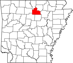
| County | Stone |
| Elevation | 1,250 ft (380 m) |
| Time zone | UTC-6 (Central (CST)) |
| • Summer (DST) | UTC-5 (CDT) |
| GNIS feature ID | 65825 [1] |
Bothersome was an unincorporated community in Stone County, Arkansas, United States. Its post office [2] is closed.