
White County is a county located in the U.S. state of Arkansas. As of the 2010 census, the population was 77,076. The county seat is Searcy. White County is Arkansas's 31st county, formed on October 23, 1835, from portions of Independence, Jackson, and Pulaski counties and named for Hugh Lawson White, a Whig candidate for President of the United States. It is an alcohol prohibition or dry county, though a few private establishments can serve alcohol.
Stone County is located in the Ozark Mountains in the U.S. state of Arkansas. The county is named for rugged, rocky area terrain of the Ozarks. Created as Arkansas's 74th county on April 21, 1873, Stone County has two incorporated cities: Mountain View, the county seat and most populous city, and Fifty-Six. The county is also the site of numerous unincorporated communities and ghost towns.

Marion County is located in the Ozark Mountains in the U.S. state of Arkansas. The county is named for Francis Marion, the famous "Swamp Fox" of the Revolutionary War. Created as Arkansas's 35th county in 1836, Marion County is home to one incorporated town and four incorporated cities, including Yellville, the county seat. The county is also the site of numerous unincorporated communities and ghost towns. The county included part of what is now Searcy County, Arkansas, with many opposing to dividing them, which helped fueled the bloody Tutt-Everett War between 1844 and 1850.
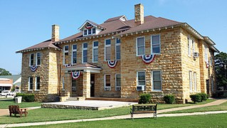
Izard County is a county located in the U.S. state of Arkansas. As of the 2010 census, the population was 13,696. The county seat is Melbourne. Izard County is Arkansas's 13th county, formed on October 27, 1825, and named for War of 1812 General and Arkansas Territorial Governor George Izard. It is an alcohol prohibition or dry county.

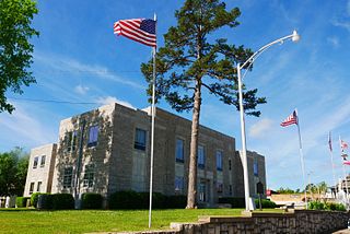
Baxter County is a county in the U.S. state of Arkansas. As of the 2010 census, the county's population was 41,513. The county seat is Mountain Home. It is Arkansas's 66th county, formed on March 24, 1873, and named for Elisha Baxter, the tenth governor of Arkansas.

Searcy is the largest city and county seat of White County, Arkansas, United States. According to 2019 Census Bureau estimates, the population of the city is 23,660. It is the principal city of the Searcy, AR Micropolitan Statistical Area which encompasses all of White County. The city takes its name from Richard Searcy, a judge for the Superior Court of the Arkansas Territory. A college town, Searcy is the home of Harding University and ASU-Searcy.

Arkansas's 1st congressional district is a U.S. congressional district in eastern Arkansas that elects a representative to the United States House of Representatives. It is currently represented by Republican Rick Crawford. With a Cook Partisan Voting Index rating of R+21, it is the most Republican district in Arkansas, a state with an all-Republican congressional delegation.
Rumley is an unincorporated community in Van Buren County, Arkansas, United States. It was founded in 1866 by Henry Rumley. Rumley originally consisted of a series of small homes, a general store and had a largely self-sustaining agrarian economy. As with many contemporary towns, Rumley was situated on a railroad. Trains would provide dry goods and mail to the local store.
The following is an alphabetical list of articles related to the U.S. state of Arkansas.

Highway 14 is an east–west state highway in north Arkansas. The route of 227.35 miles (365.88 km) begins at Boat Dock Road near Table Rock Lake and runs east to Mississippi County Route W1020 (CR W1020) at Golden Lake. Segments of the highway are part of two Arkansas Scenic Byways: Sylamore Scenic Byway in the Ozark National Forest and the Crowley's Ridge Parkway atop Crowley's Ridge.

Harriet is an unincorporated community in Searcy County, Arkansas, United States. Harriet is located at the junction of Arkansas highways 14 and 27, 8.5 miles (13.7 km) northeast of Marshall. Harriet has a post office with ZIP code 72639.
Witts Springs is an unincorporated community in Searcy County, Arkansas, United States. Witts Springs is located on Arkansas Highway 16, 16.5 miles (26.6 km) southwest of Marshall. Witts Springs has a post office with ZIP code 72686.
Glencoe is an unincorporated community in southern Fulton County, Arkansas, United States. Glencoe is located at the junction of U.S. Routes 62 and 412 and Arkansas Highway 289, 7 miles (11 km) southeast of Salem and 4 miles (6.4 km) north of Horseshoe Bend in Izard County. Glencoe has a post office with ZIP code 72539.
Dolph is an unincorporated community in Izard County, Arkansas, United States. Dolph is 4.5 miles (7.2 km) north of Pineville. Dolph has a post office with ZIP code 72528.
Sage is an unincorporated community in Izard County, Arkansas, United States. Sage is 5 miles (8.0 km) east-southeast of Melbourne. Sage has a post office with ZIP code 72573.
Violet Hill is an unincorporated community in Izard County, Arkansas, United States. Violet Hill is located on Arkansas Highway 56, 4 miles (6.4 km) west-southwest of Franklin. Violet Hill has a post office with ZIP code 72584.
Wideman is an unincorporated community in Izard County, Arkansas, United States. Wideman is 5 miles (8.0 km) west-southwest of Oxford. Wideman has a post office with ZIP code 72585.
Tri-County School District was a school district in Arkansas. It served all or parts of: Baxter, Izard, Searcy, and Stone counties. It included the communities of Big Flat and Fifty Six.


