National Register of Historic Places listings in Clark County, Arkansas

Last updated

Location of Clark County in Arkansas Map of Arkansas highlighting Clark County.svg
Location of Clark County in Arkansas

This is a list of the National Register of Historic Places listings in Clark County, Arkansas.

Contents

This is intended to be a complete list of the properties on the National Register of Historic Places in Clark County, Arkansas, United States. The locations of National Register properties for which the latitude and longitude coordinates are included below, may be seen in a map. [1]

There are 41 properties listed on the National Register in the county, including one site, Elkin's Ferry, which is part of the Camden Expedition Sites, a National Historic Landmark District associated with events of the Civil War. Another two properties were once listed but have been removed.

Contents: Counties in Arkansas


    This National Park Service list is complete through NPS recent listings posted October 27, 2023. [2]

Map all coordinates using: OpenStreetMap

Current listings

[3] Name on the Register [4] ImageDate listed [5] Location City or townDescription
1 Arkadelphia Boy Scout Hut
Arkadelphia Boy Scout Hut Arkadelphia Boy Scout Hut 002.jpg
Arkadelphia Boy Scout Hut
January 28, 2002
(#01001526)
8th St.
34°07′45″N93°03′16″W / 34.129167°N 93.054444°W / 34.129167; -93.054444 (Arkadelphia Boy Scout Hut)
Arkadelphia
2 Arkadelphia Commercial Historic District
Arkadelphia Commercial Historic District Downtown Arkadelphia, AR 001.jpg
Arkadelphia Commercial Historic District
July 20, 2011
(#11000464)
Roughly Main St. between 5th & 7th Sts., & Clinton St between 6th & 9th Sts.
34°07′12″N93°03′13″W / 34.12°N 93.053611°W / 34.12; -93.053611 (Arkadelphia Commercial Historic District)
Arkadelphia 1870-1961 commercial core of Clark County
3 Arkadelphia Confederate Monument
Arkadelphia Confederate Monument Clark County Courthouse (Arkansas) 004.jpg
Arkadelphia Confederate Monument
May 3, 1996
(#96000507)
Courthouse lawn, near the southwestern corner of the junction of Court and Clay Sts.
34°07′12″N93°03′03″W / 34.12°N 93.050833°W / 34.12; -93.050833 (Arkadelphia Confederate Monument)
Arkadelphia
4 Arkansas 7/51 Bridge
Arkansas 7/51 Bridge Highway 7 and Highway 51 bridge in Arkadelphia, AR 001.jpg
Arkansas 7/51 Bridge
February 1, 2006
(#05001591)
Highways 7 and 51
34°07′23″N93°02′47″W / 34.123056°N 93.046389°W / 34.123056; -93.046389 (Arkansas 7/51 Bridge)
Arkadelphia 1933 Parker Through Truss spanning the Ouachita River
5 James E. M. Barkman House
James E. M. Barkman House James E. M. Barkman House 001.jpg
James E. M. Barkman House
July 30, 1974
(#74000467)
406 N. 10th St.
34°07′31″N93°03′22″W / 34.125278°N 93.056111°W / 34.125278; -93.056111 (James E. M. Barkman House)
Arkadelphia ca. 1860 house in Greek and Gothic Revival styles
6 Bayou Sel September 10, 1974
(#74000468)
Address Restricted
Arkadelphia
7 Nannie Gresham Biscoe House
Nannie Gresham Biscoe House Nannie Gresham Biscoe House.JPG
Nannie Gresham Biscoe House
January 21, 2004
(#03001450)
227 Cherry St.
34°07′22″N93°02′57″W / 34.122778°N 93.049167°W / 34.122778; -93.049167 (Nannie Gresham Biscoe House)
Arkadelphia
8 Dr. Boaz House
Dr. Boaz House Dr. Boaz House.JPG
Dr. Boaz House
January 28, 1992
(#91002014)
Highway 26
34°04′23″N93°22′19″W / 34.073056°N 93.371944°W / 34.073056; -93.371944 (Dr. Boaz House)
Clear Spring
9 Bozeman House
Bozeman House Bozeman House.jpg
Bozeman House
November 14, 1978
(#78000576)
West of Arkadelphia on Highway 26
34°05′44″N93°09′03″W / 34.095556°N 93.150833°W / 34.095556; -93.150833 (Bozeman House)
Arkadelphia
10 Clark County Courthouse
Clark County Courthouse Clark County Courthouse (Arkansas) 001.jpg
Clark County Courthouse
December 1, 1978
(#78000577)
4th and Crittenden Sts.
34°07′06″N93°03′03″W / 34.118333°N 93.050833°W / 34.118333; -93.050833 (Clark County Courthouse)
Arkadelphia
11 Clark County Library
Clark County Library Arkadelphia Public Library 002.jpg
Clark County Library
November 5, 1974
(#74000469)
609 Caddo St.
34°07′14″N93°03′15″W / 34.120556°N 93.054167°W / 34.120556; -93.054167 (Clark County Library)
Arkadelphia
12 Clear Springs Tabernacle
Clear Springs Tabernacle Clear Springs Tabernacle.JPG
Clear Springs Tabernacle
February 13, 1992
(#92000057)
Junction of Highway 26 and Bobo Rd.
34°03′23″N93°23′31″W / 34.056389°N 93.391944°W / 34.056389; -93.391944 (Clear Springs Tabernacle)
Okolona
13 DeGray Creek Bridge
DeGray Creek Bridge VIEW LOOKING SSW BY 205 DEGREES - DeGray Creek Bridge, Spanning DeGray Creek at Blish Road (CR 50), Arkadelphia, Clark County, AR HAER AR-81-5.tif
DeGray Creek Bridge
January 21, 2010
(#09001239)
County Road 50 over DeGray Creek
34°09′37″N93°11′21″W / 34.160411°N 93.189214°W / 34.160411; -93.189214 (DeGray Creek Bridge)
Arkadelphia Washed away by flooding.
14 Domestic Science Building
Domestic Science Building Domestic Science Building.JPG
Domestic Science Building
December 22, 1982
(#82000800)
11th and Haddock
34°06′19″N93°03′35″W / 34.105278°N 93.059722°W / 34.105278; -93.059722 (Domestic Science Building)
Arkadelphia
15 Elkins' Ferry
Elkins' Ferry Elkins' Ferry.JPG
Elkins' Ferry
April 19, 1994
(#94001182)
Both banks of the Little Missouri River, about 10 miles north of Prescott
33°56′09″N93°21′12″W / 33.935833°N 93.353333°W / 33.935833; -93.353333 (Elkins' Ferry)
Prescott Site of the Civil War Battle of Elkin's Ferry; one of the Camden Expedition Sites, a National Historic Landmark consisting of sites in several counties; extends into Nevada County
16 Horace Estes House
Horace Estes House Horace Estes House.JPG
Horace Estes House
September 21, 1993
(#93000487)
614 E. Main St.
33°55′00″N93°08′48″W / 33.916667°N 93.146667°W / 33.916667; -93.146667 (Horace Estes House)
Gurdon
17 Flanagin Law Office
Flanagin Law Office Flanigan Law Office 001.jpg
Flanagin Law Office
December 22, 1977
(#77000245)
320 Clay St.
34°07′08″N93°03′03″W / 34.118889°N 93.050833°W / 34.118889; -93.050833 (Flanagin Law Office)
Arkadelphia
18 Gurdon Jail
Gurdon Jail Gurdon Jail.JPG
Gurdon Jail
November 13, 1989
(#89001959)
W. Joslyn and Front Sts.
33°55′11″N93°09′14″W / 33.919722°N 93.153889°W / 33.919722; -93.153889 (Gurdon Jail)
Gurdon
19 Habicht-Cohn-Crow House
Habicht-Cohn-Crow House Habicht-Cohn-Crow House 001.jpg
Habicht-Cohn-Crow House
October 3, 1985
(#85002717)
8th and Pine
34°07′21″N93°03′21″W / 34.1225°N 93.055833°W / 34.1225; -93.055833 (Habicht-Cohn-Crow House)
Arkadelphia 1870 Greek Revival house
20 Henderson State University Historic District
Henderson State University Historic District Henderson State University 002.jpg
Henderson State University Historic District
August 8, 2023
(#100008977)
1100 Henderson St.
34°07′32″N93°03′33″W / 34.1256°N 93.0592°W / 34.1256; -93.0592 (Henderson State University Historic District)
Arkadelphia
21 Capt. Charles C. Henderson House
Capt. Charles C. Henderson House Captain Charles C. Henderson House 001.jpg
Capt. Charles C. Henderson House
August 24, 1998
(#98000957)
Junction of 10th and Henderson Sts.
34°07′12″N93°03′25″W / 34.12°N 93.056944°W / 34.12; -93.056944 (Capt. Charles C. Henderson House)
Arkadelphia
22 Hoo Hoo Monument
Hoo Hoo Monument Gurdon hoohoo trainside plaque.jpg
Hoo Hoo Monument
September 2, 1999
(#94000821)
1st St.
33°55′13″N93°09′14″W / 33.920278°N 93.153889°W / 33.920278; -93.153889 (Hoo Hoo Monument)
Gurdon
23 Hudson-Jones House
Hudson-Jones House Hudson-Jones House.JPG
Hudson-Jones House
September 30, 1982
(#82002096)
East of Arkadelphia on Highway 2
34°04′11″N92°56′33″W / 34.069722°N 92.9425°W / 34.069722; -92.9425 (Hudson-Jones House)
Arkadelphia
24 Loy Kirksey House
Loy Kirksey House Loy Kirksey House, 1 of 3.JPG
Loy Kirksey House
February 3, 1992
(#91000586)
County Road 59 west of De Gray Lake
34°14′02″N93°17′45″W / 34.233889°N 93.295833°W / 34.233889; -93.295833 (Loy Kirksey House)
Fendley
25 Little Missouri River Bridge
Little Missouri River Bridge Little Missouri River Bridge.jpg
Little Missouri River Bridge
April 9, 1990
(#90000536)
formerly County Road 179, over the Little Missouri River
33°54′10″N93°18′35″W / 33.902778°N 93.309722°W / 33.902778; -93.309722 (Little Missouri River Bridge)
Prescott Bridge appears to be closed to traffic.
26 Magnolia Manor
Magnolia Manor Magnolia Manor, Arkadelphia, AR.jpg
Magnolia Manor
September 27, 1972
(#72000200)
0.6 miles southwest of the junction of Interstate 30 and Highway 51
34°06′44″N93°06′20″W / 34.112222°N 93.105556°W / 34.112222; -93.105556 (Magnolia Manor)
Arkadelphia
27 Missouri-Pacific Railroad Depot-Arkadelphia
Missouri-Pacific Railroad Depot-Arkadelphia Arkadelphia Train Station.jpg
Missouri-Pacific Railroad Depot-Arkadelphia
June 11, 1992
(#92000599)
S. 5th St.
34°07′05″N93°03′09″W / 34.118136°N 93.052453°W / 34.118136; -93.052453 (Missouri-Pacific Railroad Depot-Arkadelphia)
Arkadelphia
28 Missouri-Pacific Railroad Depot-Gurdon
Missouri-Pacific Railroad Depot-Gurdon Gurdon depot.jpg
Missouri-Pacific Railroad Depot-Gurdon
June 11, 1992
(#92000609)
Northwest of the junction of N. 1st and E. Walnut Sts.
33°55′14″N93°09′07″W / 33.920556°N 93.151944°W / 33.920556; -93.151944 (Missouri-Pacific Railroad Depot-Gurdon)
Gurdon
29 Okolona Colored High School Gymnasium
Okolona Colored High School Gymnasium Okolona Colored High School Gymnasium.JPG
Okolona Colored High School Gymnasium
September 23, 2011
(#11000686)
767 Layne St.
33°59′35″N93°20′23″W / 33.993056°N 93.339722°W / 33.993056; -93.339722 (Okolona Colored High School Gymnasium)
Okolona
30 Old Arkansas 51, Curtis to Gum Springs
Old Arkansas 51, Curtis to Gum Springs Old Arkansas 51, Curtis to Gum Springs.JPG
Old Arkansas 51, Curtis to Gum Springs
January 21, 2004
(#03001457)
West of U.S. Route 67, starting approximately 0.5 miles south of the junction of U.S. Route 67 and Curtis Cemetery Rd., and ending at its junction with Highway 26
34°01′58″N93°06′18″W / 34.032778°N 93.105°W / 34.032778; -93.105 (Old Arkansas 51, Curtis to Gum Springs)
Curtis
31 Old Bank of Amity
Old Bank of Amity OLD BANK OF AMITY.jpg
Old Bank of Amity
June 5, 1991
(#91000690)
Northwestern corner of the town square
34°15′55″N93°27′40″W / 34.265278°N 93.461111°W / 34.265278; -93.461111 (Old Bank of Amity)
Amity
32 Old US 67 Rest Area
Old US 67 Rest Area Old US 67 Rest Area.JPG
Old US 67 Rest Area
October 5, 2006
(#06000907)
Western side of Old U.S. Route 67, approx. 0.5 miles south of Middleton
34°01′12″N93°06′35″W / 34.02°N 93.109722°W / 34.02; -93.109722 (Old US 67 Rest Area)
Curtis
33 Peake High School
Peake High School Peake High School.JPG
Peake High School
January 19, 2005
(#04001499)
1600 Caddo St.
34°07′17″N93°04′03″W / 34.121389°N 93.0675°W / 34.121389; -93.0675 (Peake High School)
Arkadelphia
34 Ronoake Baptist Church
Ronoake Baptist Church Ronoake Baptist Church, 2 of 3.JPG
Ronoake Baptist Church
September 23, 2011
(#11000687)
North end of Ronoake Baptist Church Rd.
33°56′33″N93°08′48″W / 33.9425°N 93.1467°W / 33.9425; -93.1467 (Ronoake Baptist Church)
Gurdon vicinity
35 Rose Hill Cemetery
Rose Hill Cemetery Rose Hill Cemetery, Main Entrance.JPG
Rose Hill Cemetery
February 1, 1999
(#98000613)
1200 block of Main St.
34°07′07″N93°03′41″W / 34.118611°N 93.061389°W / 34.118611; -93.061389 (Rose Hill Cemetery)
Arkadelphia
36 Rosedale Plantation Barn
Rosedale Plantation Barn Rosedale Plantation Barn.JPG
Rosedale Plantation Barn
January 21, 2004
(#03001451)
879 Old Military Rd.
34°09′41″N93°06′07″W / 34.161389°N 93.101944°W / 34.161389; -93.101944 (Rosedale Plantation Barn)
Arkadelphia
37 Ross Site (3CL401) October 10, 1985
(#85003133)
Address Restricted
Whelen Springs
38 June Sandidge House
June Sandidge House June Sandidge House.JPG
June Sandidge House
February 25, 1993
(#93000093)
811 Cherry St.
33°55′21″N93°08′41″W / 33.9225°N 93.144722°W / 33.9225; -93.144722 (June Sandidge House)
Gurdon
39 C. E. Thompson General Store and House
C. E. Thompson General Store and House C. E. Thompson General Store and House.jpg
C. E. Thompson General Store and House
April 4, 2001
(#01000302)
3100 Hollywood
34°07′03″N93°05′49″W / 34.1175°N 93.096944°W / 34.1175; -93.096944 (C. E. Thompson General Store and House)
Arkadelphia
40 US 67 Bridge over Little Missouri River
US 67 Bridge over Little Missouri River US 67 Bridge over Little Missouri River.JPG
US 67 Bridge over Little Missouri River
January 24, 2007
(#06001271)
U.S. Route 67
33°52′48″N93°18′16″W / 33.88°N 93.304444°W / 33.88; -93.304444 (US 67 Bridge over Little Missouri River)
Prescott Extends into Nevada County.
41 W. H. Young House
W. H. Young House W. H. Young House.JPG
W. H. Young House
September 20, 2006
(#06000842)
316 Meador Ln.
34°07′32″N93°02′21″W / 34.125556°N 93.039167°W / 34.125556; -93.039167 (W. H. Young House)
Arkadelphia

Former listing

[3] Name on the RegisterImageDate listedDate removedLocationCity or townDescription
1 Benjamin Mercantile Building September 5, 1990
(#90001378)
January 14, 2002410 Main Street
Arkadelphia
2 Cobb-Weber House September 14, 2002
(#02000956)
January 26, 2006307 N. 6th Street
Arkadelphia Delisted after being relocated to Washington in April, 2005 [6]
3 McNeely Creek Bridge
McNeely Creek Bridge McNeely Creek Bridge.JPG
McNeely Creek Bridge
May 26, 2004
(#04000495)
September 1, 2022County Road 12
33°53′20″N93°12′34″W / 33.888889°N 93.209444°W / 33.888889; -93.209444 (McNeely Creek Bridge)
Beirne

See also

Related Research Articles

<span class="mw-page-title-main">National Register of Historic Places listings in Grant County, Arkansas</span>

This is a list of the National Register of Historic Places listings in Grant County, Arkansas.

<span class="mw-page-title-main">National Register of Historic Places listings in Sevier County, Arkansas</span>

This is a list of the National Register of Historic Places listings in Sevier County, Arkansas.

<span class="mw-page-title-main">National Register of Historic Places listings in Calhoun County, Arkansas</span>

This is a list of the National Register of Historic Places listings in Calhoun County, Arkansas.

<span class="mw-page-title-main">National Register of Historic Places listings in Bradley County, Arkansas</span>

This is a list of the National Register of Historic Places listings in Bradley County, Arkansas.

<span class="mw-page-title-main">National Register of Historic Places listings in Cross County, Arkansas</span>

This is a list of the National Register of Historic Places listings in Cross County, Arkansas.

<span class="mw-page-title-main">National Register of Historic Places listings in Faulkner County, Arkansas</span>

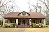
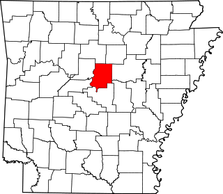
This is a list of the National Register of Historic Places listings in Faulkner County, Arkansas.

<span class="mw-page-title-main">National Register of Historic Places listings in Cleveland County, Arkansas</span>

This is a list of the National Register of Historic Places listings in Cleveland County, Arkansas.

<span class="mw-page-title-main">National Register of Historic Places listings in Garland County, Arkansas</span>

This is a list of the National Register of Historic Places listings in Garland County, Arkansas.

<span class="mw-page-title-main">National Register of Historic Places listings in Dallas County, Arkansas</span>

This is a list of the National Register of Historic Places listings in Dallas County, Arkansas.

<span class="mw-page-title-main">National Register of Historic Places listings in Jackson County, Arkansas</span>

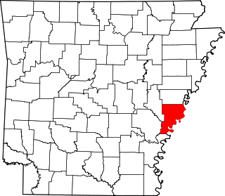
This is a list of the National Register of Historic Places listings in Jackson County, Arkansas.

<span class="mw-page-title-main">National Register of Historic Places listings in Lee County, Arkansas</span>

This is a list of the National Register of Historic Places listings in Lee County, Arkansas.

<span class="mw-page-title-main">National Register of Historic Places listings in Lonoke County, Arkansas</span>

This is a list of the National Register of Historic Places listings in Lonoke County, Arkansas.

<span class="mw-page-title-main">National Register of Historic Places listings in Lawrence County, Arkansas</span>

This is a list of the National Register of Historic Places listings in Lawrence County, Arkansas.

<span class="mw-page-title-main">National Register of Historic Places listings in Nevada County, Arkansas</span>

This is a list of the National Register of Historic Places listings in Nevada County, Arkansas.

<span class="mw-page-title-main">National Register of Historic Places listings in Ouachita County, Arkansas</span>

This is a list of the National Register of Historic Places listings in Ouachita County, Arkansas.

<span class="mw-page-title-main">National Register of Historic Places listings in Phillips County, Arkansas</span>

This is a list of the National Register of Historic Places listings in Phillips County, Arkansas.

<span class="mw-page-title-main">National Register of Historic Places listings in Saline County, Arkansas</span>

This is a list of the National Register of Historic Places listings in Saline County, Arkansas.

<span class="mw-page-title-main">National Register of Historic Places listings in Searcy County, Arkansas</span>

This is a list of the National Register of Historic Places listings in Searcy County, Arkansas.

<span class="mw-page-title-main">National Register of Historic Places listings in Sebastian County, Arkansas</span>

This is a list of the National Register of Historic Places listings in Sebastian County, Arkansas.

<span class="mw-page-title-main">National Register of Historic Places listings in White County, Arkansas</span>

This is a list of the National Register of Historic Places listings in White County, Arkansas.

References

  1. The latitude and longitude information provided in this table was derived originally from the National Register Information System, which has been found to be fairly accurate for about 99% of listings. Some locations in this table may have been corrected to current GPS standards.
  2. National Park Service, United States Department of the Interior, "National Register of Historic Places: Weekly List Actions", retrieved October 27, 2023.
  3. 1 2 Numbers represent an alphabetical ordering by significant words. Various colorings, defined here, differentiate National Historic Landmarks and historic districts from other NRHP buildings, structures, sites or objects.
  4. "National Register Information System". National Register of Historic Places . National Park Service. March 13, 2009.
  5. The eight-digit number below each date is the number assigned to each location in the National Register Information System database, which can be viewed by clicking the number.
  6. National Archives