
The Mulberry River Bridge, also known as the Silver Bridge and the Wire Ford Bridge, is a historic Pratt through truss bridge northeast of Pleasant Hill, Arkansas, now a neighborhood of the city of Mulberry. The bridge normally carries Wire Road/Center Point Road across the Mulberry River. The bridge has three spans, set on metal caissons filled with concrete, and has a total length of 342 feet (104 m). Each span measures 105 feet (32 m), and has a deck width of 12 feet (3.7 m) and a vertical clearance of 13 feet (4.0 m). In 1927 it was rebuilt when two of the three spans were washed out by the Mulberry River. The bridge is the last known multi-span Pratt through truss bridge in the state.

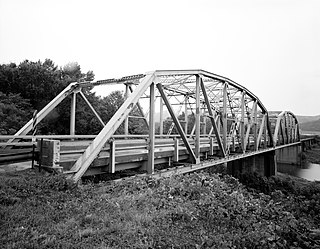
The St. Francis River Bridge carries United States Route 70 over the St. Francis River near Madison in St. Francis County, Arkansas, United States. It consists of three Parker through trusses, each 162 feet (49 m) long, and a swing bridge span 230 feet (70 m) long. With approaches, the bridge has a total length of 921 feet (281 m). The swing span is mounted on a central pier, and is rotated by two workers operating a large hickory handle. The bridge was built in 1932–33, with the swing span design made to accommodate the demands of the United States War Department that the river remain navigable by military vessels. The bridge is one of three swing-span bridges in the state. It is likely that the swinging mechanism has never been used.
The Lee Creek Bridge in Natural Dam, Arkansas was a Pennsylvania through truss bridge that was built in 1934. It was a twin-span bridge with a total length of 587 feet (179 m), which carried Arkansas Highway 59 across Lee Creek. It rested on concrete piers and abutments, had a vertical clearance of 14 feet (4.3 m) and had a roadbed 22 feet (6.7 m) wide.

The St. Louis-San Francisco Overpass is a pony and deck truss bridge built in 1937 located in Imboden, Lawrence County, Arkansas. It carries U.S. Route 62 and Arkansas Highway 115 over the Spring River and the former St. Louis-San Francisco Railroad for 1,049.9 feet (320.0 m). The bridge has three Pratt deck trusses, each 112 feet (34 m) in length, and three Parker pony trusses, also 112 feet (34 m) long, with the balance of the bridge length in steel girder truss spans. The bridge is 24 feet (7.3 m) wide.

The North Fork Bridge carries Arkansas Highway 5 over the North Fork River, or the North Fork of the White River, in Norfork, Arkansas, United States. It is a modern steel girder bridge, replacing a 1937 Warren deck truss bridge, which was the first road crossing of the North Fork River in Norfork. The 1937 bridge, demolished in 2014, was listed on the U.S. National Register of Historic Places in 1990, but was delisted in 2015.
The US 67 Bridge over Little Missouri River is a historic bridge carrying U.S. Route 67 (US 67) over the Little Missouri River, the border between Clark County and Nevada County, Arkansas. It consists of three steel Parker Pony trusses, with a total length of 1,161 feet (354 m). Built in 1931, it is one of only seven surviving multi-span Parker truss bridges in the state.

The Ouachita River Bridge is a steel Parker through truss bridge carrying Arkansas Highway 7 and Arkansas Highway 51 across the Ouachita River at Arkadelphia, Arkansas. The trusses of the bridge were manufactured in 1933 by the Luten Bridge Company, and were first used to carry Highways 7 and US 67 over the Caddo River. That bridge was disassembled in the 1950s, and the trusses were stored until used to build this bridge in 1960. The main trusses span 202 feet (62 m), while the approaches combined measure 301 feet (92 m), giving the bridge a total length of 503 feet (153 m). The deck is concrete laid on steel girders and is 24 feet (7.3 m) wide. It is one of two crossings of the Ouachita River in Clark County.

The DeGray Creek Bridge is a historic bridge in rural Clark County, Arkansas. It carries County Road 50 over DeGray Creek, west of the county seat Arkadelphia. It is single-span Pratt pony truss bridge that is 61 feet (19 m) long, resting on concrete abutments. Its trusses were purchased by the county from the Hope Bridge Company and the Stupp Brothers Bridge and Iron Works in 1915. They were moved to the present bridge circa 1970, when the original location was slated to be flooded by the construction of DeGray Dam.

The Little Cossatot River Bridge is a historic bridge in rural Sevier County, Arkansas. It is located just west of Lockesburg, carrying County Road 139H over the Little Cossatot River. The bridge is a Warren pony truss structure, 70 feet (21 m) long, with 17-foot (5.2 m) approaches made of timber stringers. The trusses were built by the Morava Construction Company of Chicago, Illinois, and are believed to be the only of the company's trusses in the state. They feature a top chord that is a solid I-beam, which is connected by riveted plates to the bottom chord. The trusses are set on cylindrical concrete piers on either side of the river.

The Osage Creek Bridge is a historic bridge in southern Benton County, Arkansas. The bridge formerly carried County Road 71 across Osage Creek, about 4.5 miles (7.2 km) north of Tontitown, but it has been closed. It is a single-span iron Pratt through truss structure, with a span of 124 feet (38 m), resting on concrete abutments. It has a lattice guardrail on one side, a feature that rarely survives on bridges of this type. The bridge was built in 1911 by an unknown builder, and is one of about 60 Pratt truss bridges in the state.

The Mountain Fork Bridge is a historic bridge in rural Polk County, Arkansas. It carries County Road 38 across Mountain Fork River north of Hatfield and southwest of Mena. The bridge consists of two spans of steel Pratt pony trusses, with a total length of 406 feet (124 m), including approach spans. The trusses are set on piers consisting of steel rings filled with concrete; each of these spans is 80 feet (24 m) long. The bridge's construction date and builder are unknown; it predates the standardization of bridge designs in the state in 1923. It is estimated to date to the early 1900s.

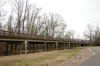
The Highway 79 Bridge was a historic bridge in Clarendon, Arkansas, United States. It was a tall two-span Warren truss bridge, formerly carrying two-lane U.S. Route 79 (US 79), a major arterial highway in the region, across the White River just west of the city's downtown. The steel truss had a total length of 720 feet (220 m), set on four concrete piers. The outer pairs of piers were 160 feet (49 m) apart, and the middle pair were 400 feet (120 m) apart. The approaches were concrete, set on concrete pilings, with the western approach continuing for some 3 miles (4.8 km) across secondary water bodies. The bridge was built in 1930-31 by the Austin Bridge Company.

The Buffalo River Bridge was a historic bridge, carrying Arkansas Highway 7 across the Buffalo River in northeastern Newton County, Arkansas. It was located in the Buffalo National River, managed by the National Park Service. It was an unusual Pennsylvania through truss, with a center span of 160 feet (49 m) and a total structure length of 375 feet (114 m). The central truss was flanked at the ends by eight-panel Warren trusses. The bridge was built in 1931 by a Kansas contractor under contract to the state highway department. At the time of its listing on the National Register of Historic Places in 1990, it was one of four known Pennsylvania through trusses in the state. It was delisted in 2022 following demolition that began in 2021.

The Judsonia Bridge is a historic bridge, carrying Van Buren Street across the Little Red River on the south side of Judsonia, Arkansas. It is a three-span metal truss swing bridge, with a total structure length of 397 feet (121 m). Its center span is 266 feet (81 m) long, and is mounted on a pivot on a central pier. It and the two approach trusses are all Warren trusses. Built in 1924, it is one of three known swing bridges in the state, and the only one with a cantilevered swinging truss. It was closed to traffic in 2007, and reopened in 2013 after restoration.
The Wallace Bridge, also known as the Nimrod Bridge, is a historic bridge in rural Perry County, Arkansas. It is located southeast of the hamlet of Nimrod, carrying County Road 18 across the Fourche La Fave River. It is a single-span camelback through truss structure, set on concrete abutments. The bridge has a truss length of 180 feet (55 m) and a roadway width of 15 feet (4.6 m). The bridge was built in 1908, its trusses constructed by the Southwestern Bridge Company. At the time of its listing on the National Register of Historic Places in 2008, it was one of three surviving camelback truss bridges in the state.

The Middle Fork of the Little Red River Bridge, also known as the Shirley Railroad Bridge, is a historic bridge in Shirley, Arkansas. It is a single-span iron Baltimore through truss, with a main span 153 feet (47 m) long, and steel beam approach spans giving it a total length of 339 feet (103 m). The main span rests on large concrete piers set in the river. The bridge was built in 1908 for the Missouri and North Arkansas Railroad, and carried the railroad until 1949. In 1978 the tracks were covered by a concrete deck, and the bridge was converted to single-lane vehicular road use, carrying County Road 125.

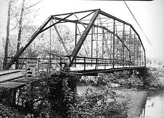
The Petit Jean River Bridge was a historic bridge in rural northeastern Yell County, Arkansas. It is located north of Ola, and carries County Road 49 across the Petit Jean River. It was a single-span Pratt through truss, with a truss length of 119 feet (36 m) long, and a total structure length of 159 feet (48 m). The trusses rest on concrete pillars. The bridge was 12 feet (3.7 m) wide, allowing for a single lane of traffic. Built in 1930, it was one of three Pratt truss bridges in the county. On February 1, 2019, the bridge was destroyed by an undertrained trucker who was unable to comprehend the clearly marked weight limits of the structure

The Ward's Crossing Bridge is a historic bridge in rural eastern Yell County, Arkansas. The bridge carries County Road 8 across the Fourche La Fave River, south of Plainview. It is a single-span camelback through truss, whose main span measures 160 feet (49 m), with a total structure length, including approaches of 240 feet (73 m). The bridge is mounted on concrete piers, and has a wooden deck carrying a single lane of traffic. The bridge was built in 1905 by the Converse Bridge Company. It is the only camelback truss bridge in the county, and one of only three known in the state.
The Petit Jean River Bridge is a historic bridge in rural southern Logan County, Arkansas. The bridge carries Old Highway 109 across the Petit Jean River between Sugar Grove and Magazine. It consists of a single-span steel Pratt through truss and two masonry approach spans, set on concrete piers in the river. The total structure length is 273 feet (83 m), with a roadway width of 19 feet (5.8 m) and a total width of 24 feet (7.3 m). The bridge was built in 1938.

The Scenic Bridge crossing Clark Fork River about 4 miles (6.4 km) east of Tarkio in Mineral County, Montana, was built in 1928. It is located at Milepost 0 on Old U.S. Route 10 West. The bridge has also been denoted 24MN304 and MDT No. L31012000+08. It was listed on the National Register of Historic Places in 2010.


