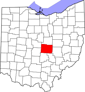
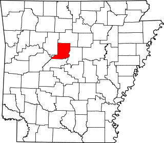
[3] Name on the Register [4] Image Date listed [5] Location City or town Description 1 Harold Adams Office Building Harold Adams Office Building September 30, 2014 (# 14000796 2101 S. H St. 35°22′31″N 94°24′38″W / 35.3752°N 94.4105°W / 35.3752; -94.4105 (Harold Adams Office Building ) Fort Smith 2 Atkinson-Williams Warehouse Atkinson-Williams Warehouse December 13, 1979 (# 79000458 320 Rogers Ave. 35°23′15″N 94°25′42″W / 35.3875°N 94.428333°W / 35.3875; -94.428333 (Atkinson-Williams Warehouse ) Fort Smith 3 William Ayers House William Ayers House July 8, 1999 (# 99000792 820 N. 12th St. 35°23′56″N 94°24′47″W / 35.398889°N 94.413056°W / 35.398889; -94.413056 (William Ayers House ) Fort Smith 4 Birney Safety Streetcar No. 224 Birney Safety Streetcar No. 224 May 19, 1994 (# 94000465 100 S. 4th St. 35°23′09″N 94°25′47″W / 35.385833°N 94.429722°W / 35.385833; -94.429722 (Birney Safety Streetcar No. 224 ) Fort Smith 5 Bonneville House Bonneville House September 22, 1971 (# 71000128 318 N. 7th St. 35°23′21″N 94°25′14″W / 35.389167°N 94.420556°W / 35.389167; -94.420556 (Bonneville House ) Fort Smith 6 C.R. Breckinridge House C.R. Breckinridge House August 7, 1979 (# 79000460 504 N. 16th St. 35°23′09″N 94°24′47″W / 35.385833°N 94.413056°W / 35.385833; -94.413056 (C.R. Breckinridge House ) Fort Smith 7 Camp Chaffee Tank Destroyer Battalion Historic District Camp Chaffee Tank Destroyer Battalion Historic District September 23, 2011 (# 11000693 Roughly bounded by Terry St., Ward Ave., Ellis St. & Darby Ave.; Roughly bounded by Ward Ave., RR spur, Taylor Ave. & Terry St. 35°23′09″N 94°24′47″W / 35.385833°N 94.413056°W / 35.385833; -94.413056 (Camp Chaffee Tank Destroyer Battalion Historic District ) Fort Smith World War II Home Front Efforts in Arkansas, MPS ; second set of addresses represents a boundary increase April 6, 2014 8 Oscar Chambers House Oscar Chambers House June 7, 2016 (# 16000320 3200 S. Dallas St. 35°21′11″N 94°23′57″W / 35.353044°N 94.399077°W / 35.353044; -94.399077 (Oscar Chambers House ) Fort Smith 9 Christ the King Church Christ the King Church December 22, 1982 (# 82000936 Greenwood Ave. at S. South St. 35°21′53″N 94°24′15″W / 35.364722°N 94.404167°W / 35.364722; -94.404167 (Christ the King Church ) Fort Smith 10 W.H.H. Clayton House W.H.H. Clayton House September 4, 1970 (# 70000130 514 N. 6th St. 35°23′30″N 94°25′15″W / 35.391667°N 94.420833°W / 35.391667; -94.420833 (W.H.H. Clayton House ) Fort Smith 11 Commercial Hotel Commercial Hotel May 7, 1973 (# 73000391 123 N. 1st St. 35°23′24″N 94°25′44″W / 35.39°N 94.428889°W / 35.39; -94.428889 (Commercial Hotel ) Fort Smith 12 Coop Creek Bridge Coop Creek Bridge May 5, 1995 (# 95000566 County Road 236 over Coop Creek 35°03′27″N 94°14′10″W / 35.0575°N 94.236111°W / 35.0575; -94.236111 (Coop Creek Bridge ) Mansfield 13 Dr. Neil Crow Sr. House Upload image September 18, 2018 (# 100002956 19 Berry Hill Rd. 35°21′28″N 94°23′06″W / 35.3578°N 94.3849°W / 35.3578; -94.3849 (Dr. Neil Crow Sr. House ) Fort Smith 14 Dodson Avenue Methodist Episcopal Church Dodson Avenue Methodist Episcopal Church March 2, 2006 (# 06000082 1922 Dodson Ave. 35°22′19″N 94°24′45″W / 35.371944°N 94.4125°W / 35.371944; -94.4125 (Dodson Avenue Methodist Episcopal Church ) Fort Smith 15 Echols Memorial Christian Church Echols Memorial Christian Church February 21, 2006 (# 06000070 2801 Alabama 35°23′03″N 94°24′06″W / 35.384167°N 94.401667°W / 35.384167; -94.401667 (Echols Memorial Christian Church ) Fort Smith 16 Elmwood Cemetery Elmwood Cemetery January 26, 2018 (# 100002004 SW of intersection of Zero & S 24th Sts. 35°19′39″N 94°24′44″W / 35.327522°N 94.412266°W / 35.327522; -94.412266 (Elmwood Cemetery ) Fort Smith 17 Ferguson-Calderara House Upload image December 11, 1979 (# 79000461 214 N. 14th St. 35°23′01″N 94°25′00″W / 35.383611°N 94.416667°W / 35.383611; -94.416667 (Ferguson-Calderara House ) Fort Smith Note: The house is listed under the wrong address. The actual address is 211 N. 14th. 18 First Evangelical Lutheran Church First Evangelical Lutheran Church January 24, 2017 (# 100000558 1115 N. D St. 35°23′13″N 94°25′00″W / 35.386807°N 94.416774°W / 35.386807; -94.416774 (First Evangelical Lutheran Church ) Fort Smith 19 Fishback Neighborhood Historic District Fishback Neighborhood Historic District September 23, 2010 (# 10000780 Roughly bounded by Rogers, Greenwood, and Dodson Aves. and 31st St.; also roughly bounded by Rogers & Dodson Aves., S. 24th, S. 26th & J Sts. 35°22′25″N 94°24′05″W / 35.373611°N 94.401389°W / 35.373611; -94.401389 (Fishback Neighborhood Historic District ) Fort Smith Second set of addresses represents a boundary increase February 3, 2015 20 Fitzgerald Historic District Fitzgerald Historic District January 26, 2018 (# 100002005 Roughly bounded by Rogers & Dodson Aves., S I, S 22nd & S 25th Sts. 35°22′32″N 94°24′28″W / 35.375536°N 94.407738°W / 35.375536; -94.407738 (Fitzgerald Historic District ) Fort Smith 21 Fort Smith Masonic Temple Fort Smith Masonic Temple November 20, 1992 (# 92001624 200 N. 11th St. 35°23′09″N 94°25′06″W / 35.3858°N 94.4183°W / 35.3858; -94.4183 (Fort Smith Masonic Temple ) Fort Smith 22 Fort Smith National Cemetery Fort Smith National Cemetery May 20, 1999 (# 99000578 522 Garland Ave. and S. 6th St. 35°22′59″N 94°25′43″W / 35.3831°N 94.4286°W / 35.3831; -94.4286 (Fort Smith National Cemetery ) Fort Smith 23 Fort Smith National Historic Site Fort Smith National Historic Site October 15, 1966 (# 66000202 Southern side of Garland Avenue [6] 35°23′17″N 94°25′52″W / 35.3881°N 94.4311°W / 35.3881; -94.4311 (Fort Smith National Historic Site ) Fort Smith 24 Fort Smith US Post Office and Courthouse Fort Smith US Post Office and Courthouse December 13, 1999 (# 99001406 30 S. 6th St. 35°23′10″N 94°25′36″W / 35.3861°N 94.4267°W / 35.3861; -94.4267 (Fort Smith US Post Office and Courthouse ) Fort Smith 25 Fort Smith's Belle Grove Historic District Fort Smith's Belle Grove Historic District July 16, 1973 (# 73000392 Bounded by N. 4th, N. 9th, N. B, and N. H Sts. [7] 35°23′27″N 94°25′15″W / 35.3908°N 94.4208°W / 35.3908; -94.4208 (Fort Smith's Belle Grove Historic District ) Fort Smith 26 Ft. Smith Confederate Monument Ft. Smith Confederate Monument April 26, 1996 (# 96000460 Courthouse Lawn, near the junction of 6th St. and Rogers Ave. 35°23′14″N 94°25′40″W / 35.3872°N 94.4278°W / 35.3872; -94.4278 (Ft. Smith Confederate Monument ) Fort Smith 27 Greenwood Gymnasium Greenwood Gymnasium June 15, 2011 (# 11000357 300 E. Gary St. 35°13′08″N 94°15′40″W / 35.2189°N 94.2611°W / 35.2189; -94.2611 (Greenwood Gymnasium ) Greenwood New Deal Recovery Efforts in Arkansas MPS 28 Greenwood Presbyterian Church Greenwood Presbyterian Church October 1, 2008 (# 08000955 103 W. Denver St. 35°12′57″N 94°15′28″W / 35.2158°N 94.2578°W / 35.2158; -94.2578 (Greenwood Presbyterian Church ) Greenwood 29 Hackett Creek Bridge Hackett Creek Bridge May 5, 1995 (# 95000568 Highway 45 over Hackett Creek 35°11′35″N 94°24′51″W / 35.1931°N 94.4142°W / 35.1931; -94.4142 (Hackett Creek Bridge ) Hackett 30 Robert Atlas Harper House Robert Atlas Harper House June 2, 2000 (# 00000612 201 N. Main St. 35°12′58″N 94°15′22″W / 35.2161°N 94.2561°W / 35.2161; -94.2561 (Robert Atlas Harper House ) Greenwood 31 Hartford Commercial Historic District Hartford Commercial Historic District July 15, 2009 (# 09000514 Buildings on the eastern side of Broadway St. from 12 N. Broadway to 106 S. Broadway 35°01′21″N 94°22′53″W / 35.0224°N 94.3814°W / 35.0224; -94.3814 (Hartford Commercial Historic District ) Hartford 32 Hartford Water Tower Hartford Water Tower January 24, 2008 (# 07001434 Pine and 1st. Sts. 35°01′30″N 94°22′37″W / 35.025°N 94.3769°W / 35.025; -94.3769 (Hartford Water Tower ) Hartford 33 Jewish Cemetery Jewish Cemetery May 12, 2021 (# 100006538 1601 South H St. 35°22′32″N 94°25′48″W / 35.3756°N 94.4301°W / 35.3756; -94.4301 (Jewish Cemetery ) Fort Smith 33 Jones Memorial Methodist Church Jones Memorial Methodist Church January 21, 2011 (# 10001157 400 E. Main St. 35°01′22″N 94°22′38″W / 35.0228°N 94.3772°W / 35.0228; -94.3772 (Jones Memorial Methodist Church ) Hartford 34 Joseph Knoble Brewery Joseph Knoble Brewery March 24, 1972 (# 72000209 N. 3rd and E Sts. 35°23′33″N 94°25′22″W / 35.3925°N 94.422778°W / 35.3925; -94.422778 (Joseph Knoble Brewery ) Fort Smith 35 Maness Schoolhouse Maness Schoolhouse May 29, 2003 (# 03000466 8801 Wells Lake Rd. 35°17′50″N 94°20′05″W / 35.297222°N 94.334722°W / 35.297222; -94.334722 (Maness Schoolhouse ) Barling 36 Maumelle Ordnance Works Locomotive #1 Maumelle Ordnance Works Locomotive #1 September 20, 2006 (# 06000835 100 S. 4th St. 35°23′11″N 94°25′52″W / 35.386389°N 94.431111°W / 35.386389; -94.431111 (Maumelle Ordnance Works Locomotive #1 ) Fort Smith 37 May-Lecta-Sweet Historic District May-Lecta-Sweet Historic District July 2, 2008 (# 08000597 Roughly bounded by May Ave., Rogers Ave., Sweet Ave., and Kinkead Ave. 35°22′43″N 94°24′03″W / 35.378694°N 94.400956°W / 35.378694; -94.400956 (May-Lecta-Sweet Historic District ) Fort Smith 38 Milltown Bridge Milltown Bridge April 6, 1990 (# 90000527 County Road 77, 1.5 miles west of Milltown 35°09′30″N 94°10′26″W / 35.158333°N 94.173889°W / 35.158333; -94.173889 (Milltown Bridge ) Milltown 39 William J. Murphy House William J. Murphy House August 7, 1979 (# 79000462 923 N. 13th St. 35°23′21″N 94°24′44″W / 35.389167°N 94.412222°W / 35.389167; -94.412222 (William J. Murphy House ) Fort Smith 40 New Theatre New Theatre November 18, 1999 (# 99001351 9 N. 10th St. 35°23′07″N 94°25′18″W / 35.385278°N 94.421667°W / 35.385278; -94.421667 (New Theatre ) Fort Smith 41 Oak Cemetery Oak Cemetery June 2, 1995 (# 95000665 Southeast of the junction of Greenwood and Dodson Aves. 35°22′09″N 94°24′05″W / 35.369167°N 94.401389°W / 35.369167; -94.401389 (Oak Cemetery ) Fort Smith 42 Old Arkansas 22, Barling Segment Old Arkansas 22, Barling Segment May 22, 2007 (# 07000439 Mayo Rd. 35°20′30″N 94°18′56″W / 35.341608°N 94.315597°W / 35.341608; -94.315597 (Old Arkansas 22, Barling Segment ) Barling 43 Old Huntington Jail Old Huntington Jail September 24, 2008 (# 08000944 223 E. Broadway St. 35°04′56″N 94°15′43″W / 35.082242°N 94.261844°W / 35.082242; -94.261844 (Old Huntington Jail ) Huntington 44 Old Sebastian County Jail Old Sebastian County Jail December 1, 1994 (# 94001413 Highway 10 , east of the County Courthouse 35°12′43″N 94°15′16″W / 35.211944°N 94.254444°W / 35.211944; -94.254444 (Old Sebastian County Jail ) Greenwood 45 Old US 71-Jenny Lind Segment Old US 71-Jenny Lind Segment September 23, 2009 (# 09000738 Doraul Acres Ln. and part of Mt. Nebo Rd. west of U.S. Route 71 35°13′51″N 94°19′04″W / 35.230736°N 94.317853°W / 35.230736; -94.317853 (Old US 71-Jenny Lind Segment ) Jenny Lind 46 Horace Franklin Rogers House Horace Franklin Rogers House May 2, 1979 (# 79000463 2900 Rogers Ave. 35°22′32″N 94°24′00″W / 35.375556°N 94.4°W / 35.375556; -94.4 (Horace Franklin Rogers House ) Fort Smith 47 St. Louis San Francisco (Frisco) Railway Steam Locomotive #4003 St. Louis San Francisco (Frisco) Railway Steam Locomotive #4003 July 12, 2004 (# 04000500 100 S. 4th St. 35°23′07″N 94°25′47″W / 35.385278°N 94.429722°W / 35.385278; -94.429722 (St. Louis San Francisco (Frisco) Railway Steam Locomotive #4003 ) Fort Smith 48 Saint Scholastica Convent Saint Scholastica Convent March 2, 2006 (# 06000084 1301 S. Albert Pike 35°22′17″N 94°23′03″W / 35.371389°N 94.384167°W / 35.371389; -94.384167 (Saint Scholastica Convent ) Fort Smith 49 Sebastian County Courthouse-Ft. Smith City Hall Sebastian County Courthouse-Ft. Smith City Hall June 8, 1993 (# 93000484 100 S. 6th St. 35°23′08″N 94°25′34″W / 35.385556°N 94.426111°W / 35.385556; -94.426111 (Sebastian County Courthouse-Ft. Smith City Hall ) Fort Smith 50 Sebastian County Road 4G Bridge Sebastian County Road 4G Bridge May 5, 1995 (# 95000569 County Road 4G over a tributary of Sugar Loaf Creek 34°59′26″N 94°25′08″W / 34.99047°N 94.41896°W / 34.99047; -94.41896 (Sebastian County Road 4G Bridge ) West Hartford Two-span reinforced concrete bridge from 1940 51 Tillman Shaw House Tillman Shaw House May 16, 1988 (# 88000561 500 S. 19th St. 35°22′44″N 94°24′47″W / 35.378889°N 94.413056°W / 35.378889; -94.413056 (Tillman Shaw House ) Fort Smith 52 South Side Baptist Church South Side Baptist Church March 2, 2006 (# 06000083 2400 Dodson Ave. 35°22′19″N 94°24′24″W / 35.371944°N 94.406667°W / 35.371944; -94.406667 (South Side Baptist Church ) Fort Smith 53 James Sparks House James Sparks House September 14, 1972 (# 72000210 201 N. 14th St. 35°23′08″N 94°24′55″W / 35.385556°N 94.415278°W / 35.385556; -94.415278 (James Sparks House ) Fort Smith 54 Spirit of the American Doughboy Monument-Fort Smith Spirit of the American Doughboy Monument-Fort Smith May 23, 1997 (# 97000454 4901 Midland Ave. 35°25′31″N 94°22′32″W / 35.425278°N 94.375556°W / 35.425278; -94.375556 (Spirit of the American Doughboy Monument-Fort Smith ) Fort Smith 55 State Highway 96 Bridge State Highway 96 Bridge May 5, 1995 (# 95000564 Highway 96 over a tributary of Vache Grasse Creek 35°13′08″N 94°13′16″W / 35.218889°N 94.221111°W / 35.218889; -94.221111 (State Highway 96 Bridge ) Greenwood 56 United Hebrew Congregation Tilles Memorial Temple Upload image January 11, 2021 (# 100006035 126 North 47th St. 35°22′32″N 94°22′47″W / 35.3756°N 94.3796°W / 35.3756; -94.3796 (United Hebrew Congregation Tilles Memorial Temple ) Fort Smith 57 United States Air Force Locomotive #1246 United States Air Force Locomotive #1246 September 20, 2006 (# 06000840 100 S. 4th St. 35°23′09″N 94°25′52″W / 35.385833°N 94.431111°W / 35.385833; -94.431111 (United States Air Force Locomotive #1246 ) Fort Smith 58 Robert Wanslow House Robert Wanslow House January 26, 2018 (# 100002007 2815 S Q St. 35°21′57″N 94°24′07″W / 35.365873°N 94.401869°W / 35.365873; -94.401869 (Robert Wanslow House ) Fort Smith 59 West Garrison Avenue Historic District West Garrison Avenue Historic District April 26, 1979 (# 79000464 100-525 Garrison Ave.; also roughly bounded by 13th St., N. B, 1st St., and Parker Ave. 35°23′18″N 94°25′37″W / 35.388333°N 94.426944°W / 35.388333; -94.426944 (West Garrison Avenue Historic District ) Fort Smith Second set of boundaries represents a boundary increase of June 6, 2001