National Register of Historic Places listings in Pike County, Arkansas

Last updated
Location of Pike County in Arkansas Map of Arkansas highlighting Pike County.svg
Location of Pike County in Arkansas

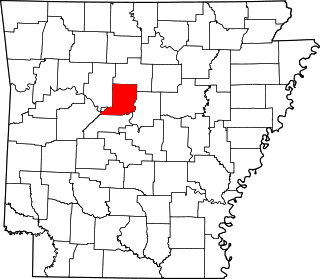
This is a list of the National Register of Historic Places listings in Pike County, Arkansas.

Contents

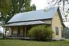
This is intended to be a complete list of the properties on the National Register of Historic Places in Pike County, Arkansas, United States. The locations of National Register properties for which the latitude and longitude coordinates are included below, may be seen in a map. [1]

National Register of Historic Places federal list of historic sites in the United States

The National Register of Historic Places (NRHP) is the United States federal government's official list of districts, sites, buildings, structures, and objects deemed worthy of preservation for their historical significance. A property listed in the National Register, or located within a National Register Historic District, may qualify for tax incentives derived from the total value of expenses incurred preserving the property.

Pike County, Arkansas County in the United States

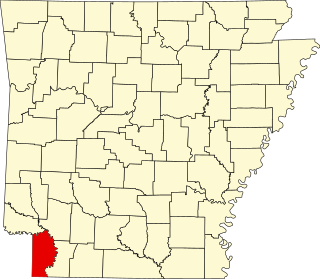
Pike County is a county located in the U.S. state of Arkansas. As of the 2010 census, the population was 11,291. The county seat is Murfreesboro. Pike County is Arkansas's 25th county, formed on November 1, 1833, and named for Lieutenant Zebulon Pike, the explorer who discovered Pikes Peak. It is an alcohol prohibition or dry county.

Arkansas State of the United States of America

Arkansas is a state in the southern region of the United States, home to over 3 million people as of 2018. Its name is of Siouan derivation from the language of the Osage denoting their related kin, the Quapaw Indians. The state's diverse geography ranges from the mountainous regions of the Ozark and the Ouachita Mountains, which make up the U.S. Interior Highlands, to the densely forested land in the south known as the Arkansas Timberlands, to the eastern lowlands along the Mississippi River and the Arkansas Delta.

There are 9 properties listed on the National Register in the county.

Contents: Counties in Arkansas
National Register of Historic Places listings in Arkansas County, Arkansas Wikimedia list article

This is a list of the National Register of Historic Places listings in Arkansas County, Arkansas.

National Register of Historic Places listings in Ashley County, Arkansas Wikimedia list article

This is a list of the National Register of Historic Places listings in Ashley County, Arkansas.

National Register of Historic Places listings in Baxter County, Arkansas Wikimedia list article

This is a list of the National Register of Historic Places listings in Baxter County, Arkansas.

This National Park Service list is complete through NPS recent listings posted April 5, 2019. [2]
Map all coordinates using: OpenStreetMap  
Download coordinates as: KML  ·  GPX

Current listings

[3] Name on the Register [4] ImageDate listed [5] Location City or townDescription
1 Conway Hotel
Conway Hotel Conway Hotel.jpg
Conway Hotel
March 6, 1986
(#86000384)
108 Courthouse Sq.
34°03′46″N93°40′33″W / 34.062778°N 93.675833°W / 34.062778; -93.675833 (Conway Hotel)
Murfreesboro
2 Crater of Diamonds State Park
Crater of Diamonds State Park Digging For Diamonds (2245556315).jpg
Crater of Diamonds State Park
June 18, 1973
(#73000386)
Southeast of Murfreesboro
34°02′03″N93°40′22″W / 34.034167°N 93.672778°W / 34.034167; -93.672778 (Crater of Diamonds State Park)
Murfreesboro
3 Glenwood Iron Mountain Railroad Depot
Glenwood Iron Mountain Railroad Depot Glenwood Iron Mountain Railroad Depot.jpg
Glenwood Iron Mountain Railroad Depot
June 28, 1996
(#96000692)
West of the junction of a Union Pacific Railroad line and U.S. Route 70
34°19′17″N93°32′45″W / 34.321389°N 93.545833°W / 34.321389; -93.545833 (Glenwood Iron Mountain Railroad Depot)
Glenwood
4 Jones General Store and Esso Station
Jones General Store and Esso Station Jones General Store and Esso Station.jpg
Jones General Store and Esso Station
June 13, 2000
(#00000609)
Highway 84, W.
34°18′42″N93°51′03″W / 34.311667°N 93.850833°W / 34.311667; -93.850833 (Jones General Store and Esso Station)
Langley
5 Murfreesboro Cities Service Station
Murfreesboro Cities Service Station Murfreesboro Cities Service Station.jpg
Murfreesboro Cities Service Station
May 19, 2003
(#03000400)
Northeastern side of the town square
34°03′45″N93°41′22″W / 34.0625°N 93.689444°W / 34.0625; -93.689444 (Murfreesboro Cities Service Station)
Murfreesboro
6 Pike County Courthouse
Pike County Courthouse Pike County Courthouse, Arkansas.jpg
Pike County Courthouse
October 16, 1986
(#86002863)
Courthouse Sq.
34°03′43″N93°41′23″W / 34.061944°N 93.689722°W / 34.061944; -93.689722 (Pike County Courthouse)
Murfreesboro
7 Rosenwald School
Rosenwald School Rosenwald School, Delight, Arkansas.jpg
Rosenwald School
September 17, 1990
(#90001381)
Highway 26
34°02′13″N93°27′17″W / 34.036944°N 93.454722°W / 34.036944; -93.454722 (Rosenwald School)
Delight
8 Self Creek Bridge
Self Creek Bridge Self Creek Bridge.jpg
Self Creek Bridge
June 9, 2000
(#00000635)
U.S. Route 70 across Self Creek and Lake Greeson
34°14′11″N93°45′24″W / 34.236389°N 93.756667°W / 34.236389; -93.756667 (Self Creek Bridge)
Daisy
9 Shelton-Lockeby House
Shelton-Lockeby House Shelton-Lockeby House.jpg
Shelton-Lockeby House
September 28, 2005
(#05001079)
Springhill Church Rd.
34°03′28″N93°44′43″W / 34.057778°N 93.745278°W / 34.057778; -93.745278 (Shelton-Lockeby House)
Murfreesboro

Former listings

[3] Name on the RegisterImageDate listedDate removedLocationCity or townSummary
1 O'Neel-Blackburn House June 18, 1973
(#76000446)
October 4, 1999W of Daisy off U.S. 70
Daisy vicinity

See also

Related Research Articles

National Register of Historic Places listings in Pike County, Pennsylvania Wikimedia list article

This is a list of the National Register of Historic Places listings in Pike County, Pennsylvania.

National Register of Historic Places listings in Pike County, Indiana Wikimedia list article

This is a list of the National Register of Historic Places listings in Pike County, Indiana.

National Register of Historic Places listings in Conway County, Arkansas Wikimedia list article

This is a list of the National Register of Historic Places listings in Conway County, Arkansas.

National Register of Historic Places listings in Carroll County, Arkansas Wikimedia list article

This is a list of the National Register of Historic Places listings in Carroll County, Arkansas.

National Register of Historic Places listings in Pike County, Ohio Wikimedia list article

This is a list of the National Register of Historic Places listings in Pike County, Ohio.

National Register of Historic Places listings in Craighead County, Arkansas Wikimedia list article

This is a list of the National Register of Historic Places listings in Craighead County, Arkansas.

National Register of Historic Places listings in Cleveland County, Arkansas Wikimedia list article

This is a list of the National Register of Historic Places listings in Cleveland County, Arkansas.

National Register of Historic Places listings in Garland County, Arkansas Wikimedia list article

This is a list of the National Register of Historic Places listings in Garland County, Arkansas.

National Register of Historic Places listings in Logan County, Arkansas Wikimedia list article

This is a list of the National Register of Historic Places listings in Logan County, Arkansas.

National Register of Historic Places listings in Ouachita County, Arkansas Wikimedia list article

This is a list of the National Register of Historic Places listings in Ouachita County, Arkansas.

National Register of Historic Places listings in Phillips County, Arkansas Wikimedia list article

This is a list of the National Register of Historic Places listings in Phillips County, Arkansas.

National Register of Historic Places listings in Monroe County, Arkansas Wikimedia list article

This is a list of the National Register of Historic Places listings in Monroe County, Arkansas.

National Register of Historic Places listings in Miller County, Arkansas Wikimedia list article

This is a list of the National Register of Historic Places listings in Miller County, Arkansas.

National Register of Historic Places listings in Scott County, Arkansas Wikimedia list article

This is a list of the National Register of Historic Places listings in Scott County, Arkansas.

National Register of Historic Places listings in Searcy County, Arkansas Wikimedia list article

This is a list of the National Register of Historic Places listings in Searcy County, Arkansas.

National Register of Historic Places listings in Union County, Arkansas Wikimedia list article

This is a list of the National Register of Historic Places listings in Union County, Arkansas.

National Register of Historic Places listings in Sebastian County, Arkansas Wikimedia list article

This is a list of the National Register of Historic Places listings in Sebastian County, Arkansas.

National Register of Historic Places listings in Stone County, Arkansas Wikimedia list article

This is a list of the National Register of Historic Places listings in Stone County, Arkansas.

National Register of Historic Places listings in Little Rock, Arkansas Wikimedia list article

This is a list of the National Register of Historic Places listings in Little Rock, Arkansas.

References

  1. The latitude and longitude information provided in this table was derived originally from the National Register Information System, which has been found to be fairly accurate for about 99% of listings. For about 1% of NRIS original coordinates, experience has shown that one or both coordinates are typos or otherwise extremely far off; some corrections may have been made. A more subtle problem causes many locations to be off by up to 150 yards, depending on location in the country: most NRIS coordinates were derived from tracing out latitude and longitudes from USGS topographical quadrant maps created under the North American Datum of 1927 , which differs from the current, highly accurate WGS84 GPS system used by most on-line maps. Chicago is about right, but NRIS longitudes in Washington are higher by about 4.5 seconds, and are lower by about 2.0 seconds in Maine. Latitudes differ by about 1.0 second in Florida. Some locations in this table may have been corrected to current GPS standards.
  2. "National Register of Historic Places: Weekly List Actions". National Park Service, United States Department of the Interior. Retrieved on April 5, 2019.
  3. 1 2 Numbers represent an ordering by significant words. Various colorings, defined here, differentiate National Historic Landmarks and historic districts from other NRHP buildings, structures, sites or objects.
  4. National Park Service (2009-03-13). "National Register Information System". National Register of Historic Places . National Park Service.
  5. The eight-digit number below each date is the number assigned to each location in the National Register Information System database, which can be viewed by clicking the number.