National Register of Historic Places listings in Hot Spring County, Arkansas

Last updated

Location of Hot Spring County in Arkansas Map of Arkansas highlighting Hot Spring County.svg
Location of Hot Spring County in Arkansas

This is a list of the National Register of Historic Places listings in Hot Spring County, Arkansas.

Contents

This is intended to be a complete list of the properties and districts on the National Register of Historic Places in Hot Spring County, Arkansas, United States. The locations of National Register properties and districts for which the latitude and longitude coordinates are included below, may be seen in a map. [1]

There are 30 properties and districts listed on the National Register in the county.

Contents: Counties in Arkansas


    This National Park Service list is complete through NPS recent listings posted November 17, 2023. [2]

Map all coordinates using: OpenStreetMap

Current listings

[3] Name on the Register [4] ImageDate listed [5] Location City or townDescription
1 Alderson-Coston House
Alderson-Coston House Alderson-Coston House.jpg
Alderson-Coston House
May 26, 1995
(#95000657)
204 Pine Bluff St.
34°21′43″N92°48′33″W / 34.361944°N 92.809167°W / 34.361944; -92.809167 (Alderson-Coston House)
Malvern
2 Bank of Malvern
Bank of Malvern Bank of Malvern.jpg
Bank of Malvern
March 13, 1987
(#87000425)
212 S. Main St.
34°21′48″N92°48′49″W / 34.363333°N 92.813611°W / 34.363333; -92.813611 (Bank of Malvern)
Malvern
3 Billings-Cole House
Billings-Cole House Billings-Cole House.JPG
Billings-Cole House
May 27, 2015
(#15000283)
725 E. Page Ave.
34°21′48″N92°48′12″W / 34.3634°N 92.8032°W / 34.3634; -92.8032 (Billings-Cole House)
Malvern
4 Blakely House
Blakely House Blakely House.JPG
Blakely House
May 3, 1976
(#76002142)
West of Social Hill on Highway 84
34°20′06″N93°01′32″W / 34.335°N 93.025556°W / 34.335; -93.025556 (Blakely House)
Social Hill
5 Cabin No. 1
Cabin No. 1 Lake Catherine State Park-Cabin No. 1.JPG
Cabin No. 1
April 20, 1995
(#95000455)
Cabin area access road at Lake Catherine State Park
34°26′15″N92°54′46″W / 34.4375°N 92.912778°W / 34.4375; -92.912778 (Cabin No. 1)
Shorewood Hills
6 Clark House
Clark House Clark House, Malvern, AR.JPG
Clark House
December 22, 1982
(#82000828)
1324 S. Main St.
34°21′24″N92°48′30″W / 34.356667°N 92.808333°W / 34.356667; -92.808333 (Clark House)
Malvern
7 Couchwood
Couchwood Couchwood.JPG
Couchwood
December 4, 1986
(#86003582)
On the grounds of the Couchwood estate, 601 Couchwood Rd. [6]
34°26′47″N92°54′50″W / 34.4465°N 92.914°W / 34.4465; -92.914 (Couchwood)
Shorewood Hills Extends into Garland County; listing encompasses artwork of Dionicio Rodriguez on the private estate of Harvey C. Couch.
8 Couchwood Historic District
Couchwood Historic District Couchwood Historic District, Remmelwood.JPG
Couchwood Historic District
May 17, 2001
(#01000487)
601 Couchwood Rd.
34°26′50″N92°54′50″W / 34.447222°N 92.913889°W / 34.447222; -92.913889 (Couchwood Historic District)
Hot Springs Extends into Garland County; listing encompasses buildings and structures of the private estate of Harvey C. Couch.
9 Garrett's Grocery Store
Garrett's Grocery Store Garrett's Grocery Store- Front.jpg
Garrett's Grocery Store
January 19, 2023
(#100008561)
2450 US 67
34°13′24″N93°00′10″W / 34.2233°N 93.0029°W / 34.2233; -93.0029 (Garrett's Grocery Store)
Friendship
10 Gatewood House
Gatewood House Gatewood House.JPG
Gatewood House
July 24, 1992
(#92000928)
235 Pine Bluff St.
34°21′41″N92°48′30″W / 34.361389°N 92.808333°W / 34.361389; -92.808333 (Gatewood House)
Malvern
11 Hodges House
Hodges House Hodges House.JPG
Hodges House
June 2, 1995
(#95000683)
Highway 7
34°16′23″N93°08′53″W / 34.273056°N 93.148056°W / 34.273056; -93.148056 (Hodges House)
Bismarck
12 Hot Spring County Courthouse
Hot Spring County Courthouse HOT SPRING COUNTY COURTHOUSE.jpg
Hot Spring County Courthouse
November 7, 1996
(#96001271)
210 Locust St.
34°21′46″N92°48′53″W / 34.362778°N 92.814722°W / 34.362778; -92.814722 (Hot Spring County Courthouse)
Malvern
13 Hot Springs Railroad Roundhouse
Hot Springs Railroad Roundhouse Hot Springs Railroad Roundhouse.JPG
Hot Springs Railroad Roundhouse
May 29, 2003
(#03000462)
132 Front St.
34°21′53″N92°48′59″W / 34.364722°N 92.816389°W / 34.364722; -92.816389 (Hot Springs Railroad Roundhouse)
Malvern
14 Jones Mill Site (3HS28) September 12, 1988
(#87001385)
Address Restricted
Jones Mill
15 Lake Catherine Quarry September 11, 1975
(#75000388)
Address Restricted
Malvern
16 Lake Catherine State Park-Bridge No. 2
Lake Catherine State Park-Bridge No. 2 Lake Catherine State Park-Bridge No. 2.JPG
Lake Catherine State Park-Bridge No. 2
May 28, 1992
(#92000528)
Highway 171 west of Slunger Creek in Lake Catherine State Park
34°25′46″N92°56′21″W / 34.429444°N 92.939167°W / 34.429444; -92.939167 (Lake Catherine State Park-Bridge No. 2)
Shorewood Hills
17 Lake Catherine State Park-Cabin No. 2
Lake Catherine State Park-Cabin No. 2 Lake Catherine State Park-Cabin No. 2.JPG
Lake Catherine State Park-Cabin No. 2
May 28, 1992
(#92000526)
Cabin area access road in Lake Catherine State Park
34°26′15″N92°54′45″W / 34.4375°N 92.9125°W / 34.4375; -92.9125 (Lake Catherine State Park-Cabin No. 2)
Shorewood Hills
18 Lake Catherine State Park-Cabin No. 3
Lake Catherine State Park-Cabin No. 3 Lake Catherine State Park-Cabin No. 3.JPG
Lake Catherine State Park-Cabin No. 3
May 28, 1992
(#92000527)
Cabin area access road in Lake Catherine State Park
34°26′15″N92°54′44″W / 34.4375°N 92.912222°W / 34.4375; -92.912222 (Lake Catherine State Park-Cabin No. 3)
Shorewood Hills
19 Lake Catherine State Park-Nature Cabin
Lake Catherine State Park-Nature Cabin Lake Catherine State Park-Nature Cabin, side view.JPG
Lake Catherine State Park-Nature Cabin
May 28, 1992
(#92000535)
Camping area access road in Lake Catherine State Park
34°26′15″N92°55′03″W / 34.4375°N 92.9175°W / 34.4375; -92.9175 (Lake Catherine State Park-Nature Cabin)
Shorewood Hills
20 Lake Catherine State Park Prisoner of War Structures
Lake Catherine State Park Prisoner of War Structures Lake Catherine State Park Prisoner of War Structures - Front.jpg
Lake Catherine State Park Prisoner of War Structures
January 24, 2017
(#100000553)
Campground, Lake Catherine State Park
34°26′15″N92°55′05″W / 34.437631°N 92.918142°W / 34.437631; -92.918142 (Lake Catherine State Park Prisoner of War Structures)
Hot Springs vicinityStone retaining wall and outdoor oven built in part by CCC and in part by German POW labor
21 Lawyers' Row Historic District
Lawyers' Row Historic District Lawyers' Row Historic District.jpg
Lawyers' Row Historic District
September 28, 2015
(#15000625)
118, 120, 130, 132 W. 2nd St.
34°21′49″N92°48′53″W / 34.3635°N 92.8146°W / 34.3635; -92.8146 (Lawyers' Row Historic District)
Malvern
22 Lono Gymnasium
Lono Gymnasium Lono Gymnasium - Front.jpg
Lono Gymnasium
January 21, 2020
(#100004896)
11702 AR 222
34°12′30″N92°42′30″W / 34.2082°N 92.7082°W / 34.2082; -92.7082 (Lono Gymnasium)
Lono
23 Malvern Commercial Historic District
Malvern Commercial Historic District Malvern Commercial Historic District, 2 of 2.jpg
Malvern Commercial Historic District
September 28, 2015
(#15000626)
Bounded by W. 1st., S. Main, W. 5th & Locust Sts.
34°21′46″N92°48′50″W / 34.3629°N 92.8138°W / 34.3629; -92.8138 (Malvern Commercial Historic District)
Malvern
24 Malvern Rosenwald School
Malvern Rosenwald School Malvern Rosenwald School.JPG
Malvern Rosenwald School
September 28, 2005
(#05001075)
836 Acme St.
34°21′45″N92°49′18″W / 34.3625°N 92.821667°W / 34.3625; -92.821667 (Malvern Rosenwald School)
Malvern
25 Missouri-Pacific Railroad Depot-Malvern
Missouri-Pacific Railroad Depot-Malvern Missouri-Pacific Railroad Depot-Malvern.JPG
Missouri-Pacific Railroad Depot-Malvern
June 11, 1992
(#92000615)
1st St.
34°21′56″N92°48′49″W / 34.365556°N 92.813611°W / 34.365556; -92.813611 (Missouri-Pacific Railroad Depot-Malvern)
Malvern
26 Morrison Plantation Smokehouse December 28, 1977
(#77000254)
Off Interstate 30
34°16′12″N92°56′50″W / 34.27°N 92.947222°W / 34.27; -92.947222 (Morrison Plantation Smokehouse)
Saginaw
27 Pine Bluff Street Historic District
Pine Bluff Street Historic District Pine Bluff Street Historic District, 1 of 5.JPG
Pine Bluff Street Historic District
February 16, 1999
(#99000154)
Pine Bluff St., roughly from Bois D'Arc to McNeal St.
34°21′42″N92°48′17″W / 34.361667°N 92.804722°W / 34.361667; -92.804722 (Pine Bluff Street Historic District)
Malvern
28 Remmel Dam
Remmel Dam Remmel Dam.JPG
Remmel Dam
September 4, 1992
(#92001084)
Remmel Dam Rd.
34°25′37″N92°53′38″W / 34.426944°N 92.893889°W / 34.426944; -92.893889 (Remmel Dam)
Jones Mill
29 Rockport Cemetery
Rockport Cemetery Rockport Cemetery.JPG
Rockport Cemetery
January 28, 2002
(#01001527)
U.S. Route 270
34°22′48″N92°49′57″W / 34.38°N 92.8325°W / 34.38; -92.8325 (Rockport Cemetery)
Rockport
30 Strauss House
Strauss House Strauss House.JPG
Strauss House
December 22, 1982
(#82000830)
528 E. Page St.
34°21′50″N92°48′26″W / 34.363889°N 92.807222°W / 34.363889; -92.807222 (Strauss House)
Malvern

Former listings

[3] Name on the RegisterImageDate listedDate removedLocationCity or townDescription
1 Bethel African Methodist Episcopal Church May 26, 2004
(#04000496)
June 12, 2013519 West Page Street
34°21′35″N92°48′58″W / 34.359722°N 92.816111°W / 34.359722; -92.816111 (Bethel African Methodist Episcopal Church)
Malvern
2 Burks Service Station June 9, 2000
(#00000630)
October 18, 2002Jct. of Page Ave. and Sullenberger
Malvern Demolished in 2001 [7]
3 Old Rockport Bridge October 7, 1982
(#82000829)
August 11, 1999W of Rockport across Ouachita River
Rockport vicinityDamaged by flooding in 1987, completely destroyed by another flood in 1990.

See also

Related Research Articles

<span class="mw-page-title-main">National Register of Historic Places listings in Pulaski County, Arkansas</span>

This is a list of the National Register of Historic Places listings in Pulaski County, Arkansas.

<span class="mw-page-title-main">National Register of Historic Places listings in Conway County, Arkansas</span>

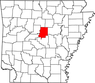
This is a list of the National Register of Historic Places listings in Conway County, Arkansas.

<span class="mw-page-title-main">National Register of Historic Places listings in Clark County, Arkansas</span>

This is a list of the National Register of Historic Places listings in Clark County, Arkansas.

<span class="mw-page-title-main">National Register of Historic Places listings in Cross County, Arkansas</span>

This is a list of the National Register of Historic Places listings in Cross County, Arkansas.

<span class="mw-page-title-main">National Register of Historic Places listings in Faulkner County, Arkansas</span>

This is a list of the National Register of Historic Places listings in Faulkner County, Arkansas.

<span class="mw-page-title-main">National Register of Historic Places listings in Cleveland County, Arkansas</span>

This is a list of the National Register of Historic Places listings in Cleveland County, Arkansas.

<span class="mw-page-title-main">National Register of Historic Places listings in Columbia County, Arkansas</span>

This is a list of the National Register of Historic Places listings in Columbia County, Arkansas.

<span class="mw-page-title-main">National Register of Historic Places listings in Garland County, Arkansas</span>

This is a list of the National Register of Historic Places listings in Garland County, Arkansas.

<span class="mw-page-title-main">National Register of Historic Places listings in Hempstead County, Arkansas</span>

This is a list of the National Register of Historic Places listings in Hempstead County, Arkansas.

<span class="mw-page-title-main">National Register of Historic Places listings in Jackson County, Arkansas</span>

This is a list of the National Register of Historic Places listings in Jackson County, Arkansas.

<span class="mw-page-title-main">National Register of Historic Places listings in Lee County, Arkansas</span>

This is a list of the National Register of Historic Places listings in Lee County, Arkansas.

<span class="mw-page-title-main">National Register of Historic Places listings in Lonoke County, Arkansas</span>

This is a list of the National Register of Historic Places listings in Lonoke County, Arkansas.

<span class="mw-page-title-main">National Register of Historic Places listings in Lawrence County, Arkansas</span>

This is a list of the National Register of Historic Places listings in Lawrence County, Arkansas.

<span class="mw-page-title-main">National Register of Historic Places listings in Ouachita County, Arkansas</span>

This is a list of the National Register of Historic Places listings in Ouachita County, Arkansas.

<span class="mw-page-title-main">National Register of Historic Places listings in Scott County, Arkansas</span>

This is a list of the National Register of Historic Places listings in Scott County, Arkansas.

<span class="mw-page-title-main">National Register of Historic Places listings in Saline County, Arkansas</span>

This is a list of the National Register of Historic Places listings in Saline County, Arkansas.

<span class="mw-page-title-main">National Register of Historic Places listings in Randolph County, Arkansas</span>

This is a list of the National Register of Historic Places listings in Randolph County, Arkansas.

<span class="mw-page-title-main">National Register of Historic Places listings in Sebastian County, Arkansas</span>

This is a list of the National Register of Historic Places listings in Sebastian County, Arkansas.

<span class="mw-page-title-main">National Register of Historic Places listings in Stone County, Arkansas</span>

This is a list of the National Register of Historic Places listings in Stone County, Arkansas.

<span class="mw-page-title-main">National Register of Historic Places listings in White County, Arkansas</span>

This is a list of the National Register of Historic Places listings in White County, Arkansas.

References

  1. The latitude and longitude information provided in this table was derived originally from the National Register Information System, which has been found to be fairly accurate for about 99% of listings. Some locations in this table may have been corrected to current GPS standards.
  2. National Park Service, United States Department of the Interior, "National Register of Historic Places: Weekly List Actions", retrieved November 17, 2023.
  3. 1 2 Numbers represent an alphabetical ordering by significant words. Various colorings, defined here, differentiate National Historic Landmarks and historic districts from other NRHP buildings, structures, sites or objects.
  4. "National Register Information System". National Register of Historic Places . National Park Service. March 13, 2009.
  5. The eight-digit number below each date is the number assigned to each location in the National Register Information System database, which can be viewed by clicking the number.
  6. Location derived from the Couchwood Historic District article of the Encyclopedia of Arkansas History and Culture; the NRIS lists the site as "Address Restricted"
  7. National Archives