Related Research Articles

Lake Hamilton and Lake Catherine are a pair of man-made lakes located in Hot Springs, Arkansas, serving as a tourist attraction for the area. Both Lakes were developed by Arkansas Power & Light.

Millstone Bluff is a natural bluff in Pope County, Illinois, United States, located near the community of Glendale. Listed on the National Register of Historic Places because of its archaeological significance, Millstone Bluff is one of three National Register sites in Pope County, along with the Golconda Historic District and part of the Kincaid Mounds State Historic Site.
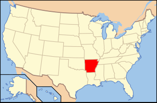
The following is an alphabetical list of articles related to the U.S. State of Arkansas.

The Sommerheim Park Archaeological District includes a group of six archaeological sites west of Erie, Pennsylvania in the United States. The sites are in Sommerheim Park, one of the few undeveloped areas of the Lake Erie shoreline, in Millcreek Township. This district has been listed on the National Register of Historic Places. This is one of the leading archaeological sites in the Erie area and along the southern shoreline of Lake Erie, due to the amount of artifacts and the lack of disturbance on the site.

Mill Creek chert is a type of chert found in Southern Illinois and heavily exploited by members of the Mississippian culture. Artifacts made from this material are found in archaeological sites throughout the American Midwest and Southeast. It is named for a village and stream near the quarries, Mill Creek, Illinois and Mill Creek, a tributary of the Cache River. The chert was used extensively for the production of utilitarian tools such as hoes and spades, and for polished ceremonial objects such as bifaces, spatulate celts and maces.

Epsilon II is a significant archaeological site on the shores of Monroe Lake in southeastern Monroe County, Indiana, United States. One of the largest preserved sites from its time period in the region, it has been designated a historic site.

Roxborough State Park Archaeological District is located in Douglas County, Colorado. Roxborough State Park, 25 miles (40 km) south of Denver, Colorado, is a Colorado State Park day park. Archaeological artifacts reflect that there were prehistoric hunter-gatherers who lived or camped, made tools from stone quarries, and farmed in the Roxborough State Park area.
The Burro Mesa Archeological District encompasses a quarry in Big Bend National Park used by Native Americans as a source of chert for chipped-stone tools. The quarry was used intermittently beginning in the paleoindian period starting about 12,000 to 13,000 years ago. The chert is found in a variety of colors and rests on top of tuff beds which themselves contain veins of kaolinite that was suitable for making claystone ornaments and beads. The quarry area is carpeted with lithic debris from the initial knapping process by which chert was rough-shaped into material of suitable size and shape for later refinement at more convenient locations.
34.5341656°N 92.9963123°WHell's Half Acre is an area of exposed rocks and boulders in a clearing near Hot Springs, Arkansas. In the 1870s there was a hotel nearby and guests would walk a trail to see the site, often referred to as a "bottomless pit". There were also many fanciful stories about a demon being trapped in a cave below. It appeared in postcards and was somewhat of a local natural wonder. It's now completely surrounded by private property.
Allendale Chert Quarries Archeological District is a set of 14 prehistoric archaeological sites located near Martin, Allendale County, South Carolina. The district includes the quarries and sites related to the processing of chert located on the bank of the Savannah River at distances of up to 1+1⁄2 miles away from the river.
Red Bluff Flint Quarries is a historic archaeological sites located near Allendale, Allendale County, South Carolina. The site consist of two outcrops of marine chert or flint, which were heavily used by Native Americans in prehistoric times as sources of tool raw materials.
The Willard Brook Quarry is a prehistoric stone quarry site in a remote portion of Piscataquis County, Maine. The quarry site is located on one of a series of outcrops near Munsungan Lake in north-central Maine, all of which have yielded stone tools found at prehistoric sites throughout northern New England. The area is known to have been frequented by Native Americans, with an extensive array of habitation sites located in the area between Munsungan and Chase Lake. The Willard Brook quarry site provides evidence that Native Americans engaged in quarrying and mining operations to recover stone suitable for conversion to tools.

The Lake Catherine State Park CCC Cabins are a collection of four rustic cabins constructed by crews of the Civilian Conservation Corps in what is now Lake Catherine State Park in Hot Spring County, Arkansas. Three of the four cabins were built for use as tourist accommodations and continue to serve in that role, while the fourth, probably built to house administrative functions, is now used in the state park as a "nature cabin", with exhibits on the history and natural environment of the park. Three of the cabins were separately listed on the National Register of Historic Places in 1992; the fourth was listed in 1995.
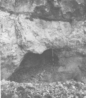
The Jones Mill Site, designated by the Smithsonian trinomial 3HS28, is a prehistoric archaeological site near Jones Mill in Hot Spring County, Arkansas. It is a deeply stratified site, with evidence of human habitation in at least three different time periods. It is one of the few documented Archaic sites in the region, with evidence of human activity dating to 3000 BCE. It is located near documented prehistoric stone quarry sites, and finds at the site include extensive stone tool construction artifacts.

The Lake Catherine State Park-Bridge No. 2 is a historic bridge, carrying Arkansas Highway 171 across an unnamed stream in the western part of Lake Catherine State Park in Hot Spring County, Arkansas. The bridge is a rustic stone structure, with stone abutments rising to low piers just above the roadway at its four corners. Built in 1935 by crews of the Civilian Conservation Corps, it is one of a number of surviving CCC-built structures in the park.
The Winooski Archeological Site, designated VT-CH-46 by state archaeologists, is a prehistoric Native American site in the city of Winooski, Vermont. First identified in 1972, it is one of the largest Native encampment sites of the Middle Woodland period in the northeastern United States. It was listed on the National Register of Historic Places in 1978, at which time it was recognized as one of just two stratified Woodland period sites in the state.
The Lake Catherine State Park Prisoner of War Structures are two structures in the campground area of Lake Catherine State Park in Hot Spring County, Arkansas. One is a stone retaining wall, about 210 feet (64 m) long and 9 feet (2.7 m) tall, built out of native stone on a concrete foundation. It is laid out in a zig-zag pattern just south of the campground's main waterfront building, and is oriented with its faces generally directed eastward to the water. The other is an outdoor cooking area, also built of stone, located a short way west of the wall. Construction of both of these structures was begun in 1942 by crews of the Civilian Conservation Corps, but was interrupted when work ceased due to World War II. Both were then later completed by German prisoners of war who were housed nearby. They are believed to be unique in the state for this construction history.
The Pi-wan-go-ning Prehistoric District is a collection of three archaeological sites located along Lake Michigan just north of Norwood, Michigan. The three sites are the Pewangoing Quarry ; Whiskey Creek ; and Fritz Trail. The district was listed on the National Register of Historic Places in 1973.
The Grand Meadow Quarry Archaeological District in Mower County, Minnesota is a 170-acre historic district which was listed on the National Register of Historic Places in 1994. The principal site within the District is The Grand Meadow Chert Quarry (21MW8). The original quarry was recorded as being 170 acres, now mostly under land plowed or developed, but a pristine 8-acre remnant of the original quarry still exists in a small woods, alongside 5 acres of restored prairie. That portion of the site, purchased by The Archaeological Conservancy as an archaeological preserve, is being developed for public access with a self-guided walking tour by the Prairie Island Indian Community and the Mower County Historical Society.
References
- 1 2 "National Register Information System". National Register of Historic Places . National Park Service. July 9, 2010.
- ↑ "Summary description of Lake Catherine Quarry Site". Arkansas Preservation. Retrieved October 23, 2015.
| Topics | |
|---|---|
| Lists by state |
|
| Lists by insular areas | |
| Lists by associated state | |
| Other areas | |
| Related | |
| | This article about a property in Hot Spring County, Arkansas on the National Register of Historic Places is a stub. You can help Wikipedia by expanding it. |