Petit Jean State Park is a 3,471-acre park in Conway County, Arkansas managed by the Arkansas Department of Parks and Tourism. It is located atop Petit Jean Mountain adjacent to the Arkansas River in the area between the Ouachita Mountains and Ozark Plateaus.

Lake Hamilton and Lake Catherine are a pair of man-made lakes around Hot Springs, Arkansas. The two lakes have greatly improved the tourism in Hot Springs. Both Lakes were created by Arkansas Power & Light.
Located near Dardanelle, Arkansas and rising 1,350 feet (410 m) above the mountain valleys of west central Arkansas, Mount Nebo has a view of 34,000 acres (140 km2) Lake Dardanelle, the Arkansas River and the surrounding mountain ridges. Atop this biblically named plateau, fringed by the Ouachita National Forest, is Mount Nebo State Park. Developed as a resort area in the late 19th century, it became a state park in 1928, its early development spearheaded by the Civilian Conservation Corps. Park activities include hiking, camping, and other outdoor pursuits.

Backbone State Park is Iowa's oldest state park, dedicated in 1919. Located in the valley of the Maquoketa River, it is approximately three miles (5 km) south of Strawberry Point in Delaware County. It is named for a narrow and steep ridge of bedrock carved by a loop of the Maquoketa River originally known as the Devil's Backbone. The initial 1,200 acres (490 ha) were donated by E.M. Carr of Lamont, Iowa. Backbone Lake Dam, a relatively low dam built by the Civilian Conservation Corps (CCC) in the 1930s, created Backbone Lake. The CCC constructed a majority of trails and buildings which make up the park.
The Death Canyon Barn is a combination barn and ranger patrol cabin in Grand Teton National Park. The barn was built in Death Canyon on the Death Canyon Trail at its junction with the Alaska Basin Trail by the Civilian Conservation Corps in 1935 in the National Park Service rustic style. Located with a clear view of Prospector Mountain, it shares a common style and purpose with the Cascade Canyon Barn to the north in the park, with minor differences attributable to available materials and the preferences of the work crews building the barns.

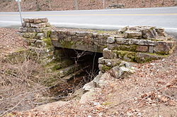
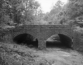
The Crowley's Ridge State Park Bridge is a historic masonry stone arch bridge in Crowley's Ridge State Park, near Walcott, Arkansas. The bridge carries the main access road to the park across a drainage ditch. It is a rusticated stone structure, about 40 feet (12 m) long, that was built c. 1935 by crews of the Civilian Conservation Corps (CCC) that were developing the park. It is one of several CCC-built structures still standing in the park, and is a well-built example of the rustic architecture popularized by the CCC.

The Sanitarium Lake Bridges Historic District encompasses a pair of stone arch bridges on Carroll County Road 317 in southern Eureka Springs, Arkansas. Built in 1891 by the Eureka Sanitarium Company to provide access to its resort, they are the only known stone arch bridges in the county, and two of a small number of known surviving stone arch bridges in the entire state. Both bridges are single-span arches fashioned out of cut stone. Marble Bridge, the northern one, has a span of 44 feet (13 m) across a ravine, while the Lake Bridge has a span of 22 feet (6.7 m) over a normally dry creek bed.

The Bard Springs Bathhouse is a historic recreational support facility in Ouachita National Forest. It is located at the Bard Springs recreation site, southeast of Mena and north of Athens in Polk County, off County Road 82 and Forest Road 106 on the banks of Blaylock Creek. It is a single story rustic stone structure, with entrances at either end into open areas for changing. The interior is lit by skylights in the roof. It was built in 1936 by a crew of the Civilian Conservation Corps, and is one of four surviving CCC structures in the immediate area.

Cold Spring is a small fresh-water spring in Ouachita National Forest, east of Waldron, Arkansas in Scott County. It is located on the south side of County Road 93, a short way south of where the road crosses Sugar Creek. The spring is protected by a stone and concrete structure erected by a crew of the Civilian Conservation Corps in c. 1936 to prevent contamination of the spring and erosion of the surrounding hillside. Near the spring are two open-air concrete water holding areas, from which a stone culvert channels the water to Sugar Creek. These CCC-built structures were listed on the National Register of Historic Places in 1993.

Shady Lake Recreation Area is a campground and public recreation area in southwestern Ouachita National Forest, southwest of Mena, Arkansas and west of Glenwood, Arkansas. The area is oriented around Shady Lake, a body of water on the South Fork Saline River impounded by a dam built c. 1940 by the Civilian Conservation Corps (CCC). The area is administered by the United States Forest Service (USFS).

The Mirror Lake Historic District encompasses Mirror Lake, a man-made lake in the Ozark-St. Francis National Forest near Fifty-Six, Arkansas. The lake was created by a crew of the Civilian Conservation Corps in 1940 by damming the creek emanating from Blanchard Spring. The district includes the lake, the dam, and two bridges, one of which was also built by the CCC, and a CCC-built observation shelter nearby. The area is now part of the Blanchard Springs Recreation Area.
The Gray Spring Recreation Area is a picnic area with scenic views in the Ozark-St. Francis National Forest of northwestern Arkansas. It is located on northern Franklin County, on Forest Road 1003, and includes a picnic shelter, comfort facilities, an outdoor barbecue pit, and picnic tables. The picnic area and Forest Road 1003 were built in 1934 by a crew from the Civilian Conservation Corps, and were listed on the National Register of Historic Places in 1995. The road, which winds precariously around Black Mountain, retains a number of surviving CCC-built features, including a bridge and many stone culverts.
The Lake Catherine Quarry is a prehistoric stone quarry in Hot Spring County, Arkansas. The site was used as a source of black novaculite, a relatively rare form of chert. Evidence of Native American quarrying activity at the site includes quarry pits, spoil piles, and a scattered talus slope of rejected materials. The site is untainted by historic quarrying, providing a potentially significant window into prehistoric quarrying methods.

The Lake No. 1 Bridge is a historic bridge, carrying Avondale Road across the northern tip of Lake Number 1 in North Little Rock, Arkansas. It is a closed-spandrel stone arch bridge with Rustic styling, built in the 1920s as part of the Lakewood development promoted by developer Justin Mathews. It has a single elliptical arch, spanning 18 feet (5.5 m), with a total structure length of 30 feet (9.1 m). It was one of eight stone arch bridges built in the state between 1923 and 1939, and one of the few that was privately built.

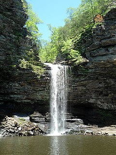
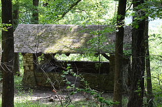
The Lake Bailey–Roosevelt Lake Historic District encompasses a landscape and buildings developed by the Civilian Conservation Corps in Petit Jean State Park, Conway County, Arkansas. The district includes both Lake Bailey and Roosevelt Lake, man-made by CCC-built dams, along with the waterfall between the two, as well as a boathouse, shelter and bathhouse, and the Cedar Creek Bridge, which crosses Roosevelt Lake at its outlet. A unique artistic feature built by the CCC are a series of what appear to be wooden stumps poking out of Roosevelt Lake, which are actually built out of concrete. These facilities were built about 1935, and form a subset of park's surviving CCC architecture.
The Spring Lake Bridge is a historic bridge in the eastern part of Ozark-St. Francis National Forest, carrying Highway 35 across an inlet of Spring Lake known as Bob Barnes Branch, in the Spring Lake Recreation Area. It is a two-span closed-spandrel stone arch bridge with a total length of 36 feet (11 m). Each arch is 10 feet (3.0 m) long and 6 feet (1.8 m) high. Built in 1936 with federal funding, it is one of the state's finest examples of a stone arch bridge.

Lacey-Keosauqua State Park is located southwest of Keosauqua, Iowa, United States. Located along the Des Moines River in Van Buren County, it was dedicated in 1921. It is the largest state park in size in Iowa. In 1990 three areas were named nationally recognized historic districts and listed on the National Register of Historic Places.

The Cove Lake Spillway Dam and Bridge are a historic structure in Ozark-St. Francis National Forest, north of Corley, Arkansas. The dam is built of earth and stone, and impounds Cove Lake, location of a recreation area in the national forest. The bridge is a five-span masonry arch structure, built across the dam spillway, where it carries Arkansas Highway 309. The dam and bridge were built in 1937 with funding from the Works Progress Administration, and is a fine example of the Rustic architecture WPA projects were known for.

The Lake Catherine State Park Prisoner of War Structures are two structures in the campground area of Lake Catherine State Park in Hot Spring County, Arkansas. One is a stone retaining wall, about 210 feet (64 m) long and 9 feet (2.7 m) tall, built out of native stone on a concrete foundation. It is laid out in a zig-zag pattern just south of the campground's main waterfront building, and is oriented with its faces generally directed eastward to the water. The other is an outdoor cooking area, also built of stone, located a short way west of the wall. Construction of both of these structures was begun in 1942 by crews of the Civilian Conservation Corps, but was interrupted when work ceased due to World War II. Both were then later completed by German prisoners of war who were housed nearby. They are believed to be unique in the state for this construction history.