
Reader is an unincorporated census-designated place in Nevada and Ouachita counties in the U.S. state of Arkansas. As of the 2010 census, its population is 66. Per the 2020 census, the population was 40.

Hensley is a census-designated place (CDP) in Pulaski County, Arkansas, United States. The population was 139 at the 2010 census. It is part of the Little Rock–North Little Rock–Conway Metropolitan Statistical Area.

Salem is a census-designated place (CDP) in Saline County, Arkansas, United States. Per the 2020 census, the population was 2,544. It is part of the Little Rock–North Little Rock–Conway Metropolitan Statistical Area.
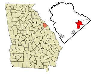
Evans is an unincorporated community and census-designated place (CDP) in Columbia County, Georgia, United States. It is a suburb of Augusta and is part of the Augusta metropolitan area. The population was 29,011 at the 2010 census, up from 17,727 at the 2000 census.

Hilltop is an unincorporated community and census-designated place (CDP) in Pike County, Georgia, United States. The population was 401 at the 2000 census.

Georgetown is a city in Quitman County, Georgia, United States. It is on the Alabama-Georgia state line next to Walter F. George Lake and across the Chattahoochee River from Eufaula, Alabama. Per the 2020 census, the population was 2,235. In 2006, Georgetown and Quitman County voted to consolidate their governments, becoming the smallest such consolidated entity in the Lower 48 states.

Helena is an unincorporated community and census-designated place (CDP) in Jackson County, Mississippi, United States. It is part of the Moss Point Metropolitan Statistical Area. Per the 2020 Census, the population was 983.
Magnet Cove is a census-designated place (CDP) and former town in Hot Spring County, Arkansas, United States. It is located in the Ouachita Mountains southeast of Hot Springs, on Arkansas Highway 51 north of U.S. Highway 270. As of the 2020 census, the town of Magnet Cove had a population of 692.
Poplar Grove is an unincorporated community and census-designated place (CDP) in Phillips County, Arkansas, United States, located on U.S. Route 49 between Marvell and West Helena. It was first listed as a CDP in the 2020 census with a population of 215.

Roland is a census-designated place in Pulaski County, Arkansas, United States. It is part of the Central Arkansas metropolitan area. Per the 2020 census, the population was 820.
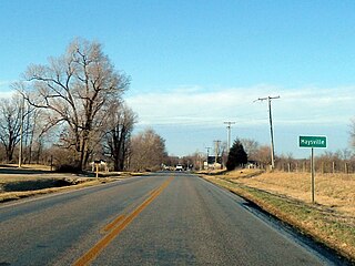
Maysville is an unincorporated community and census-designated place (CDP) in Benton County, Arkansas, United States. It is the westernmost settlement in the state of Arkansas. Per the 2020 census, the population was 117. It is located in the Northwest Arkansas region.

New Blaine is an unincorporated community and census-designated place (CDP) in Logan County, Arkansas, United States. Per the 2020 census, the population was 173.
Midway is a census-designated place in Baxter County, Arkansas, United States. Midway is 5.5 miles (8.9 km) northwest of Mountain Home. Per the 2020 census, the population was 1,036. Midway has a post office with ZIP code 72651. Long home to a rural trading post, Midway became a boomtown during the construction of the Bull Shoals Dam, and later evolved to serve tourists and retirees attracted to the lake.

Kingston is an unincorporated community and census-designated place (CDP) in northeast Madison County, Arkansas, United States. It was first listed as a CDP in the 2020 census with a population of 97.
Seville is an unincorporated community and census-designated place (CDP) in Wilcox County, Georgia, United States. Per the 2020 census, the population was 197. It lies approximately 0.5 miles (0.80 km) away from the Crisp County line, and about 4 miles (6.4 km) away from Pitts.

Lost Bridge Village is a residential subdivision near the town of Garfield in Benton County, Arkansas, United States. Per the 2020 census, the population was 397. It is located in the Northwest Arkansas region.

Rye is a census-designated place in Cleveland County, Arkansas, United States. Per the 2020 census, the population was 123.

Tumbling Shoals is a census-designated place in Cleburne County, Arkansas, United States. Per the 2020 census, the population was 902.
Woodlawn is a census-designated place in Cleveland County, Arkansas, United States. Per the 2020 census, the population was 174.

Marlboro Meadows is an unincorporated community and census-designated place (CDP) in Prince George's County, Maryland, United States. Per the 2020 census, the population was 3,655. It was newly delineated for the 2010 census prior to which the area was part of the Greater Upper Marlboro census-designated place.


